How to get there:
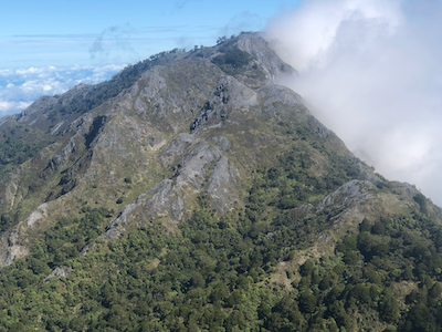
This mountain is the highest point on the Indonesian island Seram.
First, travel by air to Ambon locaated on the nearby island of XX.
There are flights from Makassar (on Sulawesi), but possibly also from a few other
Indonesian islands.
First drive from Ambon to Tulehu.
Next, take a boat from Tulehu to Masohi. From here, drive east along the south coast to location
S3.30531, E129.5560. You cross a long bridge about 6.5 kilometer before this location, then a
smaller bridge just 500 meter before the junction. A small road forks left here, this is still
paved, but single lane. Blow your horn before curves. This road serves the small village of Piliana,
location S3.270342, E129.54841, elevation about 420 meter. This is the trailhead.
Route description:
The trail starts directly from the village. The first part runs by areas
used for farming. The trail is fairly flat and quite muddy (when it rains).
Then gradually gaining elevation while crossing over to reach the upper slopes
of a hillside forming one side of a valley that must be crossed.
There is a significant loss of elevation before one reaches the small river at
the valley floor. Steeply up, then again a bit down to cross a second river.
Shortly after the second river, there is a shelter called Pos 1 (Camp 1).
The trail now gains elevation before reaching a second shelter called Pos 2.
(At S3.23952, E129.51210, elevation near 1200 meter.)
More elevation gain, then an asending traverse (going climbers left), before a
final climb to reach the top of a very distinct ridge. This is at location
S3.23016, E129.51343, elevation about 1700 meter.
The trail now ascends less steeply along the top of this ridge to Pos 3, located
at a local break in the ridge, near 2000m of elevation. More ascent follows, still on the ridge,
until the top of the ridge is reached, a very distinct, small summit up on the
left side of the trail near lcation S3.21328, E129.50485, elevation close to 2300 meter.
Finally, a descent to reach Pos 4 (Camp 4) located off on the right hand side of the
ridge, elevation about 2180 meter, location S3.20910, E129.50233. This is an ideal camp
if the climb is carried out over 3 days. It takes a reasonably strong party about 7-8
hours to get here. There are good shelters, a tent matress and a light sleeping bag should be
carried.
The next day starts with getting back up onto the ridge. This is followed as it ascends towards the
summit of a small (bonus) mountain, named Bintang.
The route crosses over only a few meter away
from its summit, the terrain is quite steep on either side. Next, a zig-zag descent to the col
that separates Bintang from higher terrain. The trail is now delightful, no more jungle, but
pretty open areas and easy footing. The route still has a few significant ups and downs crossing
smaller local hills on its way towards what has been visible as the highest summit since reaching
Bintang. Ascending a bit on the right side, the trail makes a horizontal traverse in order
to reach higher terrain that has been hidden from view, bypassing just below this summit.
A short distance onwards and the route
reaches the East summit of Binaiya.
This location is near S3.17961, E129.47356, elevation 3000 meter.
This is not the summit of the Binaiya mountain, however most climbers have appearently turned
around here. The local people (porters and guides) will claim that this is the summit. Also,
the National Park has (until recently?) said that climbers are not allowed to proceed to
the correct summit. This situation is indeed very unfortunate, the local community has
invested in building shelters and maintaining the trail. The climbing activity contributes to
their economy. However, one should clearly state where the summit is and establish as normal
practice that all climbers should have the true summit as the only reasonable goal.
From the East summit, the route descends to the col separating the two summits, you loose
about 250 meter of elevation to do so. The terrain is pretty easy, but the trail is less
clear due to minimal usage. The final ascent is steep in the lower part, then crosses several
minor "false" summit points before reaching the true summit and Seram island highpoint.
This location is near S3.173332, E129.455566, elevation about 3030 meter.
This ascent requires a full day when based at Camp 4.
The first day has about 2000 meter of ascent, summit day about 2300 meter,
while day 3 has about 200 meter of ascent for a total of 4500 meter.
Comments:
This is a pretty exclusive member of the top 100 (most) prominent mountains
of the world. In fact, when I first looked at this, perhaps 15 years ago,
I decided that the access and hike was too involved to attempt it.
However, the mountain has recently become more accessible and adequate infrastructure
(roads, trails, shelters) are now in place.
We arrived shortly before dark on July 2nd. My tent was pitched inside
a room, nice to keep mosquitos and insects in general away from us sleeping.
The next morning, Adam felt pretty
sick and decided to return to Masohi and wait for us there.
Thus, Dave and I started uphill together with Aris and local porters shortly
after 0700. We arrived at Pos 2 after a bit more than 2.5 hours and had
a long break there. Unfortunately, it started to rain. The rest of the day
it rained steadily. We arrived at Camp 4 around 1500, soaking wet. First
priority would be some dry clothes, however these were carried by the porter
that turned up last, 2 hours later. I spent the time in my sleeping bag, it
had also turned wet along the way and provided minimal, but essential warmth.
It was obvious that nothing would dry, and equally clear that the best approach
the next morning would be to get back into wet and cold clothes, keeping our
dry change in Camp 4.
July 3rd., summit day. We left after breakfast shortly after daylight aroound 0630.
Bintang was easily reached and making good progress, we made the East summit around
0900. Here Aris claimed (wrongly) that this was the true summit, we also had one
porter come along that strongly agreed. However, we knew better and flatly stated
that we were going to the next summit. The porter remained on the East summit, while
the 3 of us started descending. The true summit (about 30 meter higher) was reached
at 1030. A well deserved rest followed. We started back around 1100 and then had a new
rest with mango being served at the East summit around 1300. Still a long way back to
camp 4 including the reascent of Bintang, we arrived back in camp around 1630, a 10 hour
day.
July 4th., return to the village.
We started soon after breakfast, slightly after 0600. I first climbed to the highest
point of the ridge and took some measurements. It was not impossible that this peak
would have 100 meter of prominence, it is quite sharp and clearly higher than the maps
indicate. However, I think it is just short of 100m, most likely in the 80-90 meter
range.
After descending down the long ridge, it soon started to rain, again pretty hard.
I made a short break back down at Camp 2, then continued back to the village, arriving
there shortly after 1400 - another 8 hour effort.
We had to wait quite long for our driver to show up, but banana cakes and hot tea made
for a nice conclusion of a pretty hard 3 day climb. Thanks to Dave and Aris for good
company! We drove back to Masohi and reunited with Adam. He was fully recovered.
Our next mountain would be in East Timor, 3 days of travel to get there!