Kebnekaise (south summit)
- Kebnekaise (south summit)
- 2095 m.
- Prominence: 59 meter
- Location: In Northern Sweden
- Location: North 67:54.047, East 018:31.026 (GPS at the summit)
- Difficulty West route: YDS class 2
- Difficulty East route: YDS class 3 (with cables)
- Climbed: August 5, 2005.
- NOTE: In 2005, this summit was 2109 meter and had a prominence of 1750 meter.
- NOTE: By 2018, the summit snow cone had melted and the North Summit is now higher.
- NOTE: The North summit at 2097 meter is now the Swedish High Point,
- NOTE: This summit is an ultra with prominence 1738 meter.
|

|
Information:
How to get there:
The nearest town is the mining community of Kiruna in Northern Sweden.
Kiruna has flight connections with Stockholm as well as a good highway connection
to Narvik in Norway.
From Kiruna, drive 63 kilometer to Nikkaluokta, this is the trailhead.
There is plenty of parking, they charge SEK 15 per day to be paid in the main building.
This trailhead is at elevation 469 meter with coordinates N67:51.071, E019:01.147.
A Note on Elevation:
Until August 1. 2018, the south summit (documented here) was the highest mountain in Sweden and
an ultra prominent mountain. After this date, the North Summit became higher due to climate change
and progressive melting of the snow dome forming the south summit. The north summit is about 680
meter to the north-east as measured from the south summit. The North Summit is rock and the
elevation is 2097 meter.
Route description:
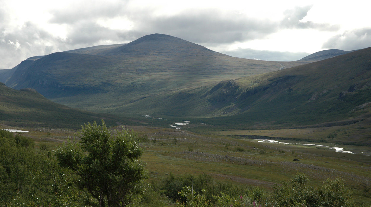
Kebnekaise is the highest mountain in Sweden and the highest point in Scandinavia
north of the Arctic Circle. The mountain is somewhat isolated from all main highways
and a standard climb normally would involve an afternoon hike into the Kebnekaise hut,
the actual climb the following day, another night at the hut, then a morning hike
back out to the trailhead on the third day.
The hut hike:
This hike is about 18 kilometer and runs on a good trail all the way. In fact, the hiker
will encounter a feature almost unique to Sweden: Long stretches of parallel planks in order
for the hiker not to step directly on a trail in Mother Nature. I have absolutely no sympathy
for this practice myself. The "bridges" are foreign to the mountain landscape, they do possibly
protect some Swedes from getting their boots wet in the meadows, but they are really ugly in an
otherwise beautiful landscape. Some people think this is all in order to protect the environment,
however, this is clearly false. On this hike the trail crosses only one or two short sections of
boulders, what do you find there? - wooden "bridges" in order to make the walk a bit easier. A million
hikers could step on these boulders and they would still look pretty much the same. In meadows, yes the
track from hikers would be visible, but so what? The worst spots could perhaps be identified and reinforced
with a natural element like rock on a very heavyily used trail like this one. This (bad) practice is not unique
to the Kebnekaise area. I have seen kilometer after kilometer of the same ugly practice in Sylane (further south),
this is an area with little traffic compared to the Kebnekaise trail.
Returning to trail description, the trail can be divided into three parts.
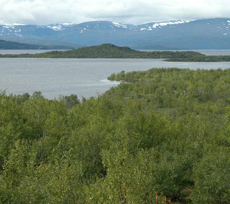
The first part starts from Nikkaluokta, you cannot miss it as it passes under a portal, then heads into the
birch forest. Initially, the trail is covered by bark, but this ends soon. This first section is about
5 kilometer long and runs to the lake Laddjujavri, elevation 511 meter. At Laddjujavri, there are some
services to hikers, you can buy food near the lake. Waffels with cloudberries can be recommended.
The second leg runs parallel with the lake, then along the river for about 4 kilometer. This section can
also be skipped by taking a regularly scheduled boat across the lake and partway up the river. This service
cost SEK 130 per person in 2005. They like to advertise that you save 6 kilometer of hiking, but the
truth is closer to 4. (At a moderate pace of hiking, this section is completed in less than one hour.)
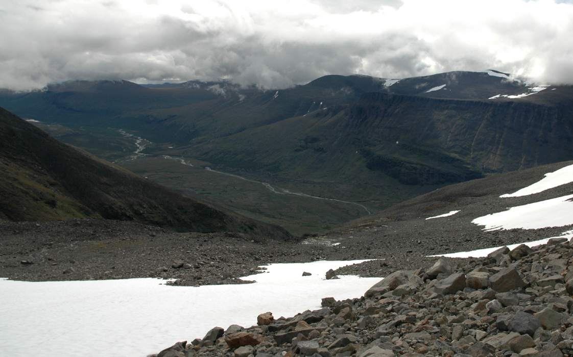
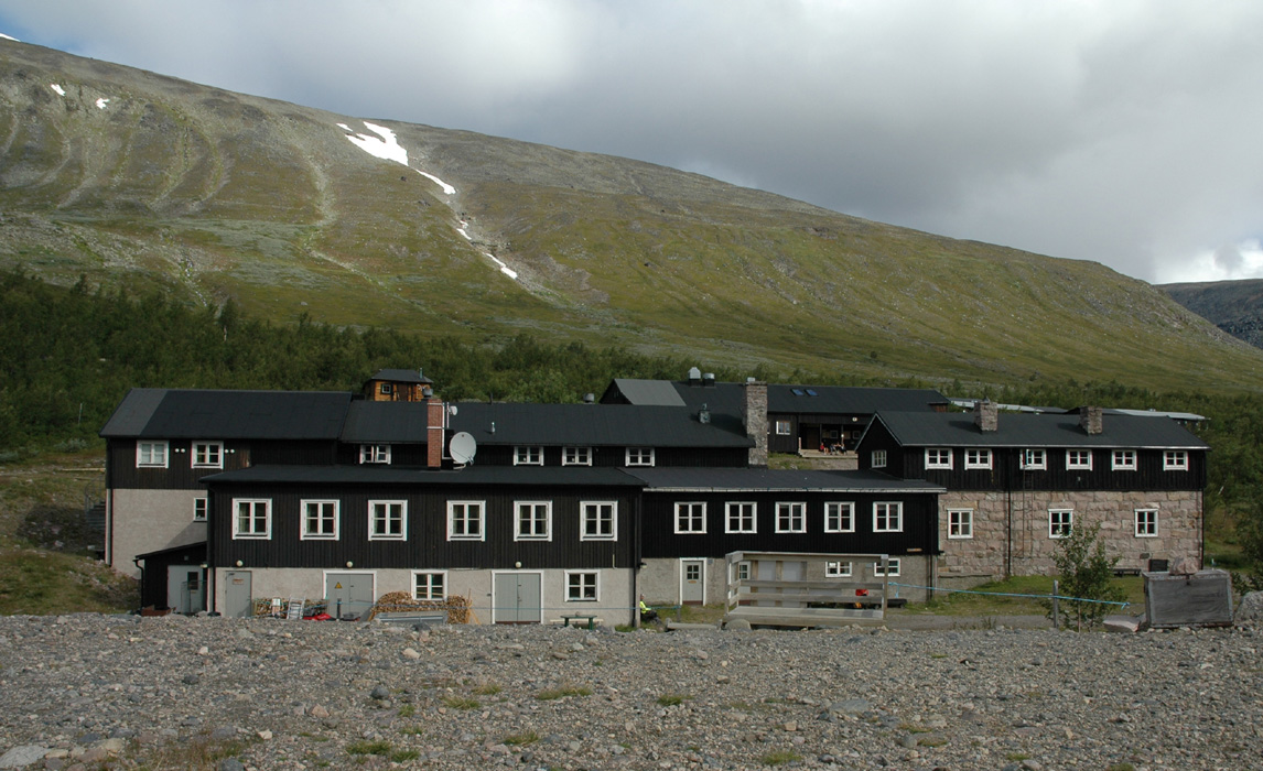
From the upper boat landing, the remaining leg to the Kebnekaise hut is about 8 kilometer. This section
is the prettiest as the landscape becomes more varied and the bigger mountains start to appear. The trail
curves a bit north towards Darfalvaggi (a valley), then crosses the river on a good bridge before the
final kilometer straight west to the Kebnekaise mountain hut. This hut sits at about 675 meter above sea level with
location N67:52.089, E018:37.218.
The Climb:
There are two routes from the hut to the summit. They start out together and finishes
together, but for the most part they split in what is called the East Route (shorter and steeper)
and the West Route, longer, but without any exposure or difficulties.
The East Route:
This route can most easily be described as having four parts:
Part 1, leaves the Kebnekaise hut together with the West route, but forks off to
the right after a short while. You can easily see the side valley up to your right that
this route will follow. The trail climbs on the right hand side of the creek, sometimes fairly
steeply. In one place where forward progress is obstructed, the trail makes a sharp right in order
to gain higher ground. This section, on rock, has been secured by a short wire, however most hikers
will see little reason to use it. Higher up, the trail crosses fairly loose rocks and gravel before
approaching a big patch of snow that fills the narrow upper valley and extends to the plateau above.
Cross this snow on an ascending traverse to the left. If the snow is hard, then crampons and an ice axe
may be useful, however, one may also circumvent this problem by crossing a bit lower and then follow the left
side of this snow field up to higher ground. Continue uphill, generally towards northwest. At elevation 1400 meter
you should be near location N67:53.112, E018:33.757. Ascend another 100 vertical meter, possibly on easy snow, to
reach 1500 meter of elevation, this concludes part 1.
Part 2, starts with a flat, small plateau, then a couple of
small morraines in order to reach the tiny Björlings Glacier. Cross it more or less going west along a local
"ridge", that is, the glacier falls off very gently to your left, but also ever so slightly to your right. This crossing
is normally completely free of crevasses, that is, you may spot a few very small ones running across your path,
but they will tend to be too small to pose any danger. One can safely attempt this route without any rope or
glacier equipment, however, one should naturally be aware of the fact that this is
a glacier (although a very small one indeed) and
that there potentially could be hazards that need special attention.
As you approach the west side of the glacier you will see that the ridge becomes much more distinct and
that it rises more steeply up towards the mountain cliffs ahead. Climb this ridge as it gets more narrow with
drops on both sides, then gets a bit wider and less exposed on its final section connecting with the
rock wall. As you reach the steep rock, part 2 comes to conclusion.
Part 3 is the climbing section of the ascent. It is secured with a continuously running (wire) cable bolted to
the rock along the route. Thus, it is an easy example of a "Via Ferrata" as it is called in Italy and the
Dolomites, or a "Klettersteigen" as such a route is named in Austria and German speaking parts of Switzerland.
Most people with limited fear for heights would be comfortable completing this route with a hand on the
cable when needed. A completely secure approach is to climb it with a harness and a "Via Ferrata Kit" as
is used in the Dolomites. If one ignores the cables, the technical difficulty of this route is YDS class 3,
except for a single "crux point" that requires a YDS class 4 move.
This section starts at elevation 1745 meter, location N67:53.465, E018:31.083.
The route first proceeds right along a ledge, initially with a short descending section. This ledge connects
to a gully that runs all the way to the top edge of this rock wall. The first part of this gully is quite
easy, shortly before the top you will encounter a short passage where the rock is much steeper (a bit "in your face"),
but there are many good foot and hand holds if you take your time to look around. This is the class 4 crux, most
people will use the cable as well as an additional fixed rope (with knots) that is provided here. Above this
point, the route is quite easy. You pass a memorial plaque for a climber and guide that fell to
his death here in 2002. This section tops out at elevation 1846 m, location N67:53.504, E018:30.987, concluding
part 3 of this route to Kebnekaise.
Part 4 starts out on a very gentle trail among boulders in order to connect with an old mountain hut.
Here, the trail also merges back together with the longer West Route. The trail continues up the slope which is
gradually more and more gentle, almost flat before you reach elevation
2065 meter at location N67:53.986, E018:30.972. Here, the final snow dome starts pretty abruptly.
The slope is steeper and it can be icy. Most of the time hikers do get up here without the use
of crampons, however, they might come handy under the most unfavorable conditions. As long as there
is some snow (often new) on the slope, the ascent is easy. The short climb to the summit is
well protected by the slope of ascent, however, the ridge becomes increasingly more narrow and near the
summit you have exposure both left and right.
The West Route:
This route is longer than the east route, and involves a bit more elevation gain since a smaller
mountain, Vierramvare, must be crossed along the way.
The route is marked with cairns and red paint the entire way from the Kebnekaise hut to
the final snow cone that forms the Kebnekaise summit.
Due to a better trail and no difficulties,
a strong hiker could still complete this route almost as fast as doing the east route.
Where the east route forks right, follow the sign for the west route straight ahead on a good trail that
ascends more as you get further into the valley.
You must cross two rivers, the second being bigger than the first.
Normally, this crossing is not a problem, just find a good spot and cross
one section at a time. You may have to step on rocks that are somewhat under water, but they
tend to be stable and not slippery. After the river, the trail climbs quite steeply on the left
side. There may be a snow field going up at the very end of the valley, but the trail climbs a better
line. Here, the route bends slightly south of west as it climbs to the saddle between
Duolbagorni (1662m) and Vierramvare (1711m). From this
saddle, the trail turns more north as it climbs Vierramvare. Actually, the trail crosses the summit about
140 meter east of the highest point, but this is just a few meter lower than the top. Hikers have built
hundreds of small cairns where the trail crosses over to the north side of the mountain. Descend almost 200
vertical meter to the 1525 meter saddle separating Vierramvare from Kebnekaise. You will notice this hill
better on your return hike. From here on, the trail will gradually climb the south slopes of
Kebnekaise. You reach the two huts high on the mountain, merge with the East Route trail and climb more gradually
towards elevation
2065 meter at location N67:53.986, E018:30.972. Here, the final snow dome starts pretty abruptly.
The slope is steeper and it can be icy. Most of the time hikers do get up here without the use
of crampons, however, they might come handy under the most unfavorable conditions. As long as there
is some snow (often new) on the slope, the ascent is easy. The short climb to the summit is
well protected by the slope of ascent, however, the ridge becomes increasingly more narrow and near the
summit you have exposure both left and right.
Comments:
On guides and level of experience:
There is a trend on many (well known) mountains around the world today to organize
commercial treks/climbs with guides. This is good to the extent that it provides
an opportunity for more people to experience the mountain with adequate measures to
ensure safety. Thus many people that otherwise might not complete the hike/climb may
be able to do so. (One should note that there is still an element of risk, less experienced
people may still run into trouble or have an accident even if a guide is supervising the
trip.)
In some locations this works well, people hike/climb with or without the guide based on
their own judgement and skill. However, at an increasingly number of sites there is
a frightening development. Partly trying to protect their business, guides, hotels and/or
even authorities try to make a guided climb THE ONLY OPTION.
In fact, I think this is a big error. I believe that even the guide business might improve if
one provided more correct information and encouraged people to make their own decisions based
on facts readily available.
I shall warn against this
development and do hope that people who enjoy mountains do work together to prevent
what would indeed be a very bad future.
There were ample signs of this trend already at Kebnekaise. Deliberately, the mountain hut does
not post factual information about the East Route. They explicitly say that the route is not
marked and that it is "dangerous". Similarly, the glacier crossing is somewhat blown out
of proportions, it could have been a completely safe, marked route across there if this is
what one wanted to encourage.
They provide no information about the fact that the climbing section
is in fact a "Via Ferrata", thus people could bring a "Via Ferrata kit" if they wanted to
climb it alone, but with full protection. The guided trip that was supposed to take place when we
hiked Kebnekaise was cancelled on short notice, this was the second day in a row and obviously,
many people were unhappy. Fortunately, Sweden's law "Allemannsretten" (Every Man's Right) guarantees
that anybody can hike/climb anywhere without asking permission.
Examples from other countries: On Sicily the guides claim that climbing without them is illegal,
they have a big sign supporting this claim, however, the authorities (only when the issue is pressed)
contradict this. In Slovakia, there are reports that guides deliberately remove cairns in order for
people to get more easily lost unless they use a guide. This is extremely unethical.
They also claim that climbing without paying
is illegal. In the USA some mountains are owned by people who charge climbers or even try to
deny access altogether. These are just a few examples, there are many more.
Brief trip report:
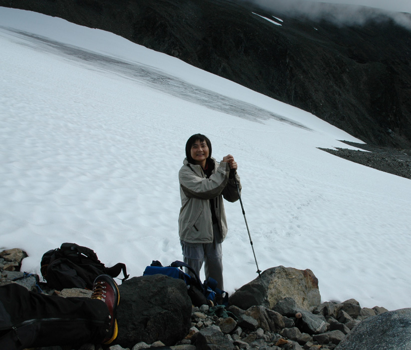
I did this hike with Edward Earl (Esquared) from San Diego and his Chinese
friend (living in Sweden), Fora Chan. We picked her up at the Kiruna airport
and we all got completely soaked in heavy rain as we hiked from the trailhead to
the lake Laddjujavri where we had a welcome break and some food while waiting about
30 minutes for the boat (as well as finding shelter from the rain).
Shortly after resuming the hike, the weather improved and the rain almost stopped.
We all arrived at the hut quite wet, but in good spirit. The hike from the trailhead to
the Kebnekaise hut had taken 4 hours including a 30 minute wait for the boat and a 30 minute boat
ride.
The next morning came with more rain and the official guided tour to Kebnekaise
was cancelled. However, the rain stopped and the day turned out to be quite OK for
walking, despite the clouds (fog higher up) and lack of sunshine. Several people decided
to hike the peak via the longer west route when the guide cancelled their scheduled trip.
We started out around 0730, having decided to hike the east route up and then return via
the west route. I was slightly concerned that the steeper section on the east route could
be problematic for Fora. After all, this climb was likely a longer and slightly more advanced
hike than what she had been doing earlier. We quickly ascended in the valley leading up to the
glacier, Fora did a good job on the somewhat steep snowfield following in the steps that I kicked
up and across. The hike across the glacier was a stroll. I wanted to show Fora a crevasse, but had
to look long and hard before finding a tiny one, just big enough to illustrate the concept and
be able to poke my axe down into it. Soon, we were at the climbing section. I was somewhat
surprised to see that the route had been turned into a "Via Ferrata", thought that there should
have been proper information about this at the Kebnekaise hut. I immediately decided that Fora should
get a chest harness and a sling in order to clip into the cable. In this way she would feel more
secure and we would know that she had an extra level of safety as well. The climb went very well
indeed. Fora came up the steep class 4 crux without any trouble. On top, we knew that the rest
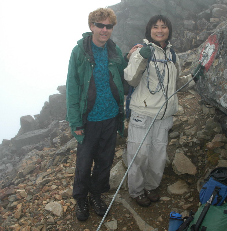
would be easy, however, she was getting tired and we did not summit until around 1400.
The summit was in dense fog with very limited views. Edward and I set out with crampons to explore
the route across to the north summit. Initially, the ridge fell vertically on the left, somewhat
more gently to the right. After descending a bit, the ridge became more horizontal, but the drop
to the right side became more severe. The only place to walk was on the very top of a very narrow
ridge. Blue ice on the steep slopes both left and right, then fog. Very limited visibility indeed.
Edward and I stopped and considered the somewhat unfriendly terrain ahead. We did agree that without
any idea of how long the ridge would stay at this quality, or possibly get worse before improving,
one should consider using the rope for added safety. However, to provide real protection on a ridge
like this is not trivial, and we did not have much time since Fora was sitting at the very top of
Kebnekaise tired and soon cold. Visibility, in order to judge the entire route would have been
very welcome. We decided to leave the north summit alone, a focus on the return hike with Fora that should have
first priority.
We were interested in the north summit because at elevation 2097 meter, it may become the highest
mountain in Sweden in the relatively near future. The map elevation of Kebnekaise is 2113 meter, my
GPS measured it to 2109 meter. Thus, if the snow dome melts another 12 meter, then the north summit
will take over as the Swedish HP. The north summit is the highest rock point in Sweden. If/when this
HP changes, it will become significantly more difficult to climb the highest (and also most prominent)
peak in Sweden.
We left the summit shortly before 1500, it soon became clear that the return hike would indeed take
a long time, as Fora moved more slowly (not faster) downhill than uphill. We had reserved a gourmet
(a la carte) dinner at 2000 to celebrate the ascent, thus it was agreed that I should go ahead in order
to possibly move the dinner to a later time. Edward and Fora would stay together, the trail was trivial,
but quite long.
I reached the Kebnekaise hut at 1800, a beer from the store and a warm sauna was just what I needed.
I was able to delay our dinner until 2100, just as I was about to (slowly) start the meal Edward
showed up and told me that he had guided Fora across the river then gone ahead to inform and catch
dinner. Poor Fora, I felt sorry for her. This turned into a marathon test, but she had a strong
will and was very brave indeed. After dinner, Edward went out to meet her and finally, at 2300 after
hiking for 15.5 hours, Fora made it back to the hut. Her dinner was saved, but needed heating before
serving.
The next day, it was pretty clear that Fora should take advantage of the helicopter shuttle to
the parking (SEK 500). Her legs and body clearly needed a longer time to recover from yesterdays all out
effort. Edward and I started at 0830, we reached the upper boat landing at 1000, had a break for about
15 minutes and let the boat go, then hiked to the other boat stop in about 45 minutes. I could not
resist a lunch break here with more waffles and cloudberries. The last leg of the hike took slightly
less than an hour and we arrived back at the trailhead exactly 4 hours after leaving the Kebnekaise hut.
We then drove back to Tromsø, Norway where we had a next morning flight to Munich in order to
continue our E5 trip with an attempt on Zugspitze, the HP of Germany.
Resources: