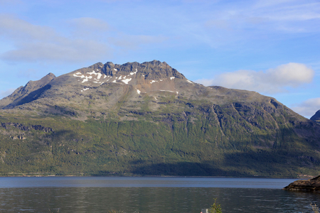
Løksetinden
- Løksetinden
- 1241 m.
- Primary factor 1066 m
- Location: North 68.93225, East 017.56007 (The summit)
- Troms, Norway.
- Climbed May 13. 2005 and August 30. 2020.
- Difficulty: YDS class 3 (winter rating)
|
|
Information:
How to get there:
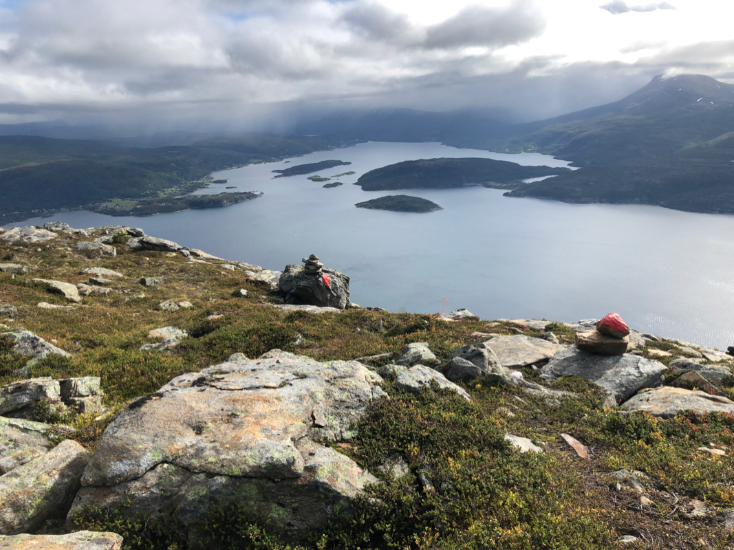
This peak is located near the Salangen fjord in South Troms. From Tromsø, drive
73 km on Hwy. E8 to Nordkjosbotn, then follow Hwy. E6 south. After 88 km, you pass the
village Setermoen. Continue another 9 km south on E6, then turn right on Hwy. 851 towards
Sjøvegan. You reach Sjøvegan 19 km after leaving E6. There is accommodation here,
call (+47)77171204. The place also has a nice pub that serves pizza. Contine 10 km north-west along
Hwy. 84 (direction Sørreisa) until the road fork where Hwy. 848 (direction Harstad) goes left
across a bridge. Drive 4.1 km along this road. Shortly before the trailhead, a road signed Løksa
goes left. The trailhead is on a hilltop where you can park the car off the road on your left side.
The precise location is north 68:55.647, east 017:38.620, elevation 51 meter.
Route description:
Note that this description is based on a ski ascent, the nature of this route
is likely very different in summer conditions.
Cross the road and walk back (to your right) about 75 meter. There is a wooden
sign here pointing uphill that reads Løksetinden. A small creek comes
down right next to the trail. The trail climbs uphill towards west, it is pretty
well marked with red paint, initially on trees, later on rocks, however many such
marks were likely hidden by snow when I did this climb. At elevation 300 meter, the
trail is more level as it enters and crosses the flat bottom of a nice bowl. The creek
Navarselva is then crossed as you approach the ridge Aksla that looms above in front of you.
This ridge is the key to access the higher part of the mountain.
Find a good line up in order to gain the lower part of the ridge, this is about
100 vertical meter to about 500 meter of elevation. This slope
is quite steep and may avalanche in winter. Once on the ridge proper, the route heads
straight up. The steepest part is towards the end, here it may be better to stay slightly
on the left side of the ridge. In May, there may be some rocks and patches that are free from
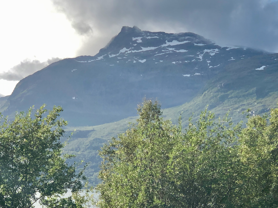
snow on this side. The ridge tops out and the slope becomes much more gentle at elevation 743 meter.
However, the ridge continues uphill and eventually forms the corner between the two main
summit ridges of Løksetinden, one running east to west, the other south to north, each about
one kilometer long. In winter, the Aksla ridge that we ascend, has a big (overhanging) cornice on its
right side (the north-east side). When reaching close to 900 meter of elevation, approach this cornice
with care and locate a point where the hillside below is less steep and where one can cross down a steep
but short slope, this point provides a safe way off the ridge. Exit the ridge here, the access point just below
the ridge has elevation 870 meter and location north 68:55.777, east 017:34.434.
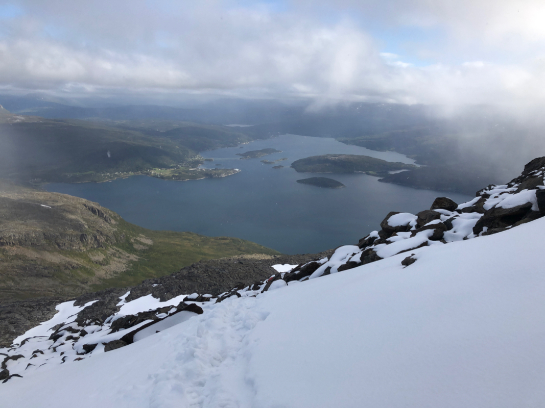
From here, observe a broad, nice slope that heads north and gently climbs towards the north end of the
south-north summit ridge. The route runs close to or slightly higher than a large, very visible rock that
is located in this area. This part is easy, gain access to the north ridge slightly above 1120 meter of elevation.
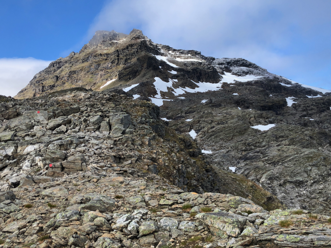
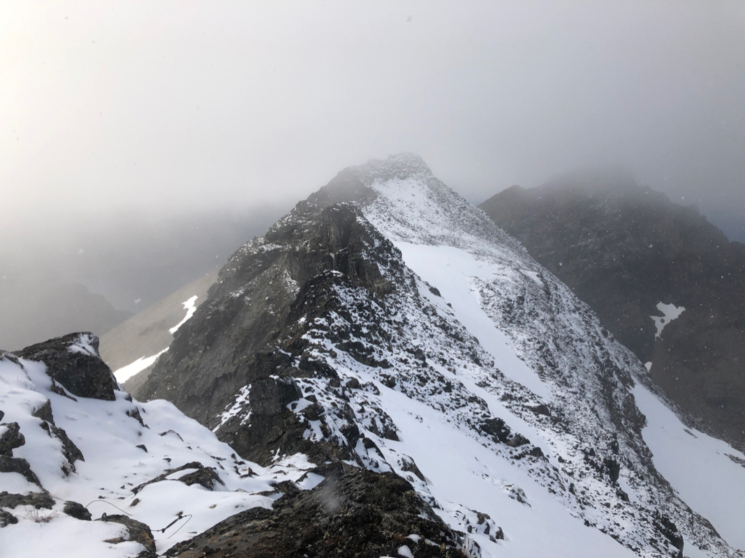
From here, turn south and climb to 1200 meter along the ridge, the slope is still wide and quite gentle.
From here, a very impressive scenery opens up. The ridge continues south, but now corniced (on the east side), considerably
sharper, with a west side that is steep enough to avalanche. You see the apex where the east-west ridge joins the
ridge you are on. The M711 map indicates a summit at 1237 meter at the far end (west) of this ridge. The traverse to
this point looks far from trivial under winter conditions. In summer, one can most likely stay a bit on the right
side of the ridge whenever needed in order to bypass difficulties. However, the good news is that the true summit
of Løksetinden at 1242 meter is
the second top, that is, considerably closer than the west summit.
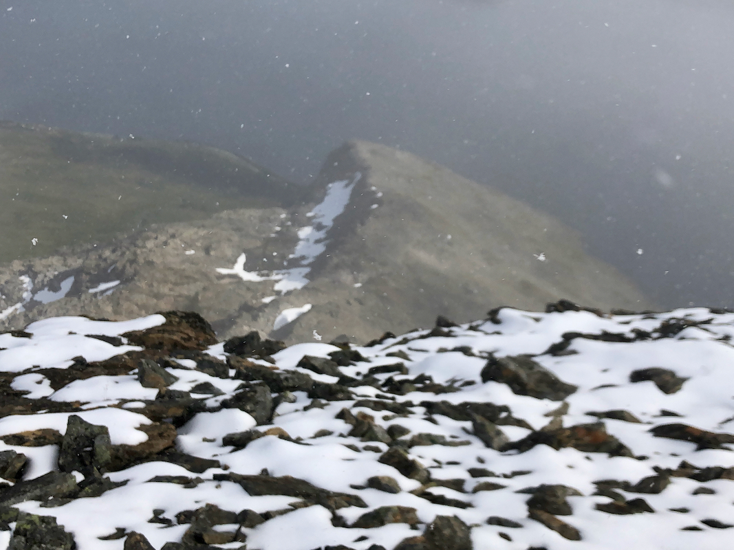
The bad news, is that even this point looks challenging in winter. Leave your skis at this point and
proceed with ice axe and crampons (depending on the snow conditions). As you get close to the summit block, further
progress looks a bit easier than the first impression from further away. Move left and climb back onto the main
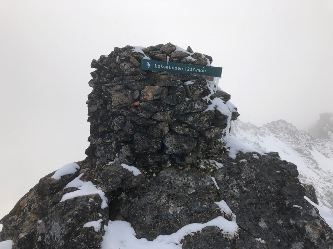
ridge higher up, then proceed to the cairn. This big cairn with
a sign proclaiming Løksetinden is
not at the true summit.
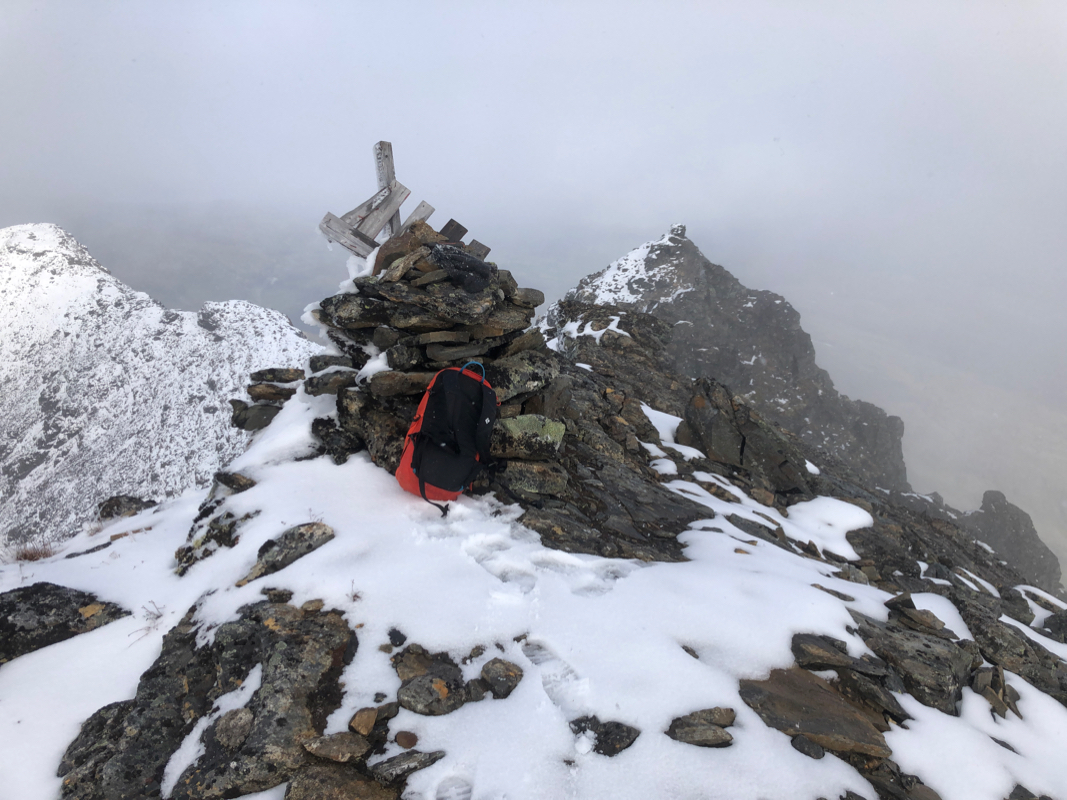
Another, narrow ridge connects this to the highest point, proceed with caution.
In fact, under winter conditions (or wet and slippery summer conditions), the best route is to
bypass the first summit on the right hand side,
then climb the true summit.
This is almost certainly a lot easier in summer. Return the same way.
Comments:
I climbed this mountain solo. The conditions were far from perfect.
The weather forecast was pretty miserable and turned out to be accurate. Rain, snow showers, hail
and clouds providing white-out conditions all combined to make this last T5 climb a challenge.
Add to this, the rotten unpredictable snow, sometimes breaking in a way that made falls unavoidable,
the general steepness of the route, the huge corniced summit ridge and the final crux climb where
both crampons and the active use of an ice axe was required. However, there were several brief breaks
in the clouds with sunshine and improved visibility throughout the day. This all combined to a lasting
memory of a spectacular finish of T5, exhausting, but worthwhile.
I started around 0800, carried the skis to about 180 meter of elevation. I then skied until gaining the
Aksla ridge at 500 meter of elevation. From here, I again carried the skis up the steep ridge to elevation
743 meter. From here, I skied up the ridge and off it at the safe spot, then continued skiing until
reaching 1200 meter of elevation on the north summit ridge. I had a mix of visibility, mainly clouds (fog),
but a few brief moments of sunshine that provided help in finding a good route. I had expected the north ridge
to be a bit broader and, in particular, its slopes much less steep than what I found. At elevation 1200 meter,
a break in the clouds revealed the entire ridge system to me and I did not like what I saw.
The ridge was narrow, it did not look safe to move off on the west side due to steep, slab snow (avalanche prone).
On the east side, continuously overhanging cornices.
Further ahead, a vertical looking tower seemingly blocking the way.
Pretty exhausted already and with little hope of success,
I still left my skis and poles and proceeded to explore the ridge on foot.
At the base of the tower (summit block), visibility became limited, but it looked possible
to climb. I needed my crampons due to an icy section, but then proceeded to climb with surprisingly
little difficulty. Another ridge and the highest point, I was quite happy when
locating the cairn on this summit and confirming the
correct elevation of 1242 meter with my GPS. I reached the summit at 1300 after 5 hours of hard work.
The descent also required attention as the snow was now even more rotten on the Aksla ridge. I was back
at the car at 1600, having a sense of finishing T5 with a peak that was harder work than expected.
This
route is normally a summer route. In winter, the steepness of the terrain and possible
avalanche conditions (I saw several smaller avalanches en route), calls for caution.
Only experienced people should consider skiing this route.
This was peak number 14, the last peak on my T5 trip.
Fourteen peaks all on the Norway 100 finest list of
high prominence (one at 996 m, 13 with more than 1000 m), climbed in 14 days.
Net vertical climbing 16913 meter, (net difference between trailheads and summits, actual
vertical substantially more). Six additional independent (primary factor exceeding 100 meter)
peaks were climbed along the way to these giants, so a total of 20 new peaks.
10 peaks climbed in good weather, 3 in clouds and fog, and the last one under very mixed
conditions.
It is a bit sad and very different from Southern Norway to observe that there are more
tracks from snow scooters than from skis. In particular, these noise and pollution generating machines
had tracks to all summits that due to gentle steepness could be attained in this motorized way.
Officially, the use of these machines is only permitted for work related activities, not for "pleasure",
however, the tracks prove that this is largely ignored. The activity was also highest in the weekends and
on a public holiday, clearly showing that the local authorities defacto accepts the near unlimited use of these
machines for recreational purposes in the general wilderness.
Many thanks to Torstein for a great trip on Jiehkkevarri and to Ståle
for good company on 6 of the peaks in the first week.
T5 was successful beyond any expectations!
Go to Previous peak Spanstinden.
or return to
First T5 peak Jiehkkevarri.
Return to Petter's mountain page.
Notes added August 30th. 2020:
I decided to make a second visit to this peak, under summer conditions to fully understand
the summit points. When I was there in May 2005, doing a ski ascent, the summit area had
dense fog and I did not really see the different summit points.
I stayed at the Fjellkysten hotel and actually overslept. However, the forecast called for
improving weather after lunch so a late start was actually ok. I started hiking at 1045 and
quickly got to the ridge Aksla. The well marked trail ascends below the ridge, the climbs onto
the ridge with a few zig-zag turns. Obviously, I did not ski up here, but came up the ridge from
a point lower down and to the left of the summer trail.
The trail was nice and easy to follow, however this part of Aksla is steep, I was quite impressed
when reflecting on my climb 15 years ago with skis. The trail is well marked as it gets off
the ridge to the right and proceeds up the slope in order to gain then main north ridge.
I arrived at the beginning of the ridge at the north summit, marked as 1201 meter on the map.
The ridge going south is pretty easy, however with 10 cm of new snow more care was needed than
dry summer rock. I ascended the first summit,
there was a huge cairn with a sign saying
Løkstinden. It is really bad practice to have such a fine red marked trail end at the
wrong summit. Many people will actually believe that this is the summit. The time was 1350.
I next descended towards the col, but came to an exposed point with snow and slippery conditions.
It looked doable, but not within the margins of safety that I want on a solo climb like this.
I therefore turned around and decided to traverse below on the west side, this looked much safer.
Getting back to the big cairn, I met a young fellow that just arrived, he told me he had walked in my
footsteps. We had a short chat, I asked if he wanted to climb the highest
peak, but he was not interested in such a project.
I descended back down from the first summit, traversed on the west side, then climbed a fairly easy
line staying on the west side of the
top ridge, gaining the summit.
A nice place with a surprisingly
flat, local area. Returning back down, I was ready to start the trip back at 1430. A delightful return
hike got me back to the car by 1635.
Note on elevations:
There are now Lidar elevation data for this area. The first summit with the
cairn, measures 1236 meter. The true summit is 1240.6, rounded to 1241 meter.
The west summit is close competing at 1239.7, rounded to 1240 meter.
Resources: