Mount Madjaas
- Mount Madjaas
- 2117 m.
- Prominence: 2117 m
- Panay island HP, Philippines.
- Location: North 11.38933, East 122.16198 (GPS)
- Difficulty: (YDS) class 3
- Climbed April 29, 2023.
Mount Madjaas
|
|
How to get there:
This is the highest mountain on the Philippine island of Panay. The nearest town is
Culasi, it can be reached quite easily from Kalibo further north. Kalibo has an airport with
several daily flights to/from Manila.
From Culasi, drive or find a motorcycle transport to the small village of Flores.
The current road descending to a large, concrete bridge (across Tibiao river) at location
N11.3743, E122.1107, elevation about 240 meter. Access to the village of Flores is directly right,
immediately before the bridge. The "mountain house" in Flores supporting treks to the peak is located
at N11.37179, E122.10870, (walk the main road, then turn right, the house is then on your left a short
distance up the road.
Route description:
The trail starts directly from the concrete bridge, follows the edge of farm property and ascends steeply
to reach a small hut at location N11.37269, E122.11881, elevation near 490 meter. The trail continues uphill from here
and reaches a nice open spot with a wooden pole near location N11.36621, E122.12447, elevation about 770 meter.
Above this, you enter the jungle, the trail remains nice without obstacles as it climbs along a broad ridge
to reach a main crest at elevation near 1230 meter. This ridge descends going south (left). Descend all the way
to the river where the main camp for this mountain is located. This descent gets a bit rougher/steeper in several
spots, compared to the initial ascending trail.
The camp is near N11.36870, E122.14354, elevation about 1020 meter. The camp is well equipped, a pretty big shelter
where guides and porters can spend the night as well as space for perhaps 20 tents.
The trail continues directly across the river from the campsite. First ascending steeply to reach a more gentle, uphill
ridge. Overall, this trail becomes considerably more complex/steep from this point to the summit. There are several
short sections where the use of hands are needed. A few places with potentially slippery rocks, mostly steepish terrain
with roots, often good handholds. The next section of the route traverses fairly horizontally, you will pass below
a small waterfall, a very good place to take water. Next, a steeper uphill segment will get you to the top
of the main ridger, elevation near 1810 meter. The trail next follows this ridge (more or less) about 2 kilometer to
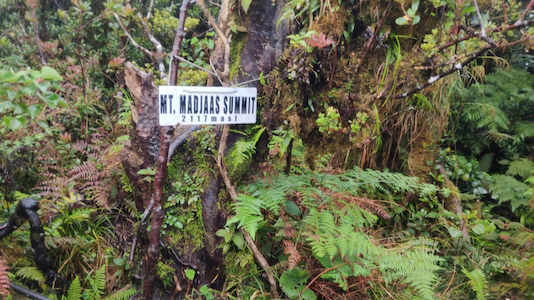
the summit. There are several smaller descending sections along the way. The highest point is about 5 meter left of
the summit sign, a small open area that most likely has a very good view.
Comments / Trip report:
Since the very early planning of this trip, the goal had been 7 peaks, however, peak number 7 was
hard to settle. Many candidate peaks were considered, but there was always something wrong. Many
Philippine peaks are closed for hiking, this seems pretty random and hardly serves any purpose.
Some peaks still have security concerns others were difficult to reach on short notice.
With the good assistance of Win Calleja, we finally had a plan that involved spending 3 nights
on the island of Panay, returning to Manila on April 30. just in time for our flights scheduled
on May 1.
We travelled from Baguio after climbing Pulag the previous day. After a brief
stop in Manila, we took an afternoon flight to Panay and stayed in a hotel in Kalibo that night. The next
morning, we travelled to Culasi, spent a few hours sorting out the climbing permit with the local office
of tourism as well as the local police station. When all this was done, we proceeded to Flores. Here, the
guide and some porters were waiting.
Starting around 1000, it was quite hot walking up the first hill, but our local support then announced
lunch already at the hut after only 30 minutes. We continued to the camp, arriving there
around 1330. The place soon filled completely with tents. Some Cristian organization had a common
trip this weekend. We relaxed and enjoyed dinner before going to sleep in our 2 tents. Deividas
had not been well and quite slow, a slight concern of our guide. We accepted that he would start at
0400 the next morning while Rob and I should start at 0530, well after the arrival of daylight.
The summit climb was quite long, the trail having quite many sections that were steep or otherwise
full of obstacles. I summited at 0940, so 4:10 to get up here. Rob and Deividas started back down while
I took a 10 minute break at the summit. It was raining and thus no view. Leaving around
0950, I walked rather carefully back down, the rain was pouring and the trail both steep and slippery.
A short break by the small waterfall to fill my bottle, then the remaining part, arriving back
at camp by 1345.
Lunch, a change of clothes that were soaking wet, then departure around 1430. First, about 200 meter
of ascent, then the easier trail back down. I took abnother rest at the nice view point with a pole.
Next, proceeding downhill, Rob caught up with me and we arrived back down at the concrete bridge
by 1700.
A cold beer at the mountain house in Flores, then 3 motorcycles would bring us back down
to our hotel in Culasi. This was just around sunset, so the day had been well used.
The next day, we flew back to Manila. A successful trip with all 7 ultras in the bag.
On May 1st. we all departed to start our somewhat different journeys home.