Mount Pulag
- Mount Pulag
- 2926 m.
- Prominence: 2926 m
- Luzon island HP, Philippines.
- Location: North 16.59775, East 120.89877 (GPS)
- Difficulty: (YDS) class 1
- Climbed April 26, 2023.
Mount Pulag
|
|
How to get there:
You need to stop at the National Park Office to obtain a proper
permit and attend a mandatory orientation. This is located on
the right hand side of the road at N16.52079, E120.83384, elevation near
1400 meter.
Next, continue uphill on a slightly more narrow road to the trailhead.
This is at N16.57205, E120.88017, elevation about 2450 meter.
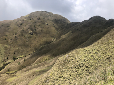
Route description:
From near the upper end of the road, there is a ranger station on your
left were you will find your guide. The route begins by following the concrete
road uphill until it changes to dirt. Continue along the dirt road as it traverses
the hillside, then descends slightly. On a fairly horizontal stretch, the trail forks
right, a 5 meter descent to the trail that then continues horizontally below the road.
This trail has a very solid metal guard-rail initially. Next, the trail crosses a small
hill before descending to a crossing saddle, then more steeply uphill, again, just a
short ascent before turning left. From here, the trail is pretty well defined
as it continues across the next hill, eventually another long and gentle descent, perhaps
50-60 meter vertical loss. You will arrive at the official campsite, located near the
edge of the jungle.
From here, the trail is set with stones as it runs pretty straight and fairly level before
turning left to begin its final ascending section. Traversing below several minor hills it
finally ascends the highest peak.
The summit has an official survey marker as well as a welcome to Pulag sign.
Comments / Trip report:
We had ascended Tapulao the day before, then driven to
Baguio City, where we booked 2 nights at the local Eurotel hotel.
Starting at 0600 in the morning, we first drove to the DENR, national park check-in office.
Win organized our permits and we had to sit in on a mandatory orientation, first a video next
some remarks from a park employee. This session was pretty meaningless for us, but we did
survive. Next, driving about 1000 meter higher, we arrived at the trailhead. Win located our
mandatory guide and we could start walking at 0930.
The trail was easy to follow and I reached the summit at 1115. The rest of our party followed
and we could enjoy a fine summit, initially pretty clear, but clouds were accumulating.
We left at 1150 and walked back to the car, arriving there at 1340, so 1:50 going down.
The first few rain drops were now in the air and within 30 minutes of leaving towards Baguio City,
the clouds opened with lightning and thunder
while the water splashed down by the buckets.
We made a brief detour just before Baguio City to visit a local hill.
Overall, a very successful trip, thanks to Wil for setting it up and Rob and Deividas
for good company.