How to get there:
The starting point for this trip was Lake City, a small town
about 55 miles from Gunnison (Hwy 149 running south from Hwy 50
at the east end of a lake which is about 9 miles west of
Gunnison along Hwy 50). In Lake City, go west on 2nd. street and
follow the road with the sign Engineer Pass (Henson Creek Road)
for about 8 km. There is a sign reading Nellie Creek Road for a
4WD road that forks to the right. This road was closed by snow. Route description:
We skied up Nellie Creek Road, climbing steadily on
the right side of the creek.
The road crosses the creek and forks after about 3 km, with a
cliff rising in the middle. Take the left fork
(the jeep-road makes an almost 180 degree left turn here).
The trail continues first on the left side of the creek,
then on its right side reaching a flat, somewhat wide
valley area before climbing gently through some more trees to
the (summer) 4WD trailhead.
From here one continues up the main valley, the tree line is
quite distinct. The summer trail makes a big bend left in order
to gain Uncompahgre's south ridge, however in winter it seems
best to ski directly to the very distinct notch just left of
the peak itself (4110 m). We left the skis in the notch and climbed the
snow slope quite close to the steep cliffs facing west. This slope
ends in a wide, flat shoulder that can be followed (a bit to the
right) back to the south ridge. The west facing slopes of Uncompahgre
are considerably less steep here and the most practical winter
route continued a traverse climbing only gently onto the west slopes
until a scree area that then could be used to regain the south ridge.
Again, the ridge is broad and quite level, then there is one more
"step", short, but fairly steep snow before reaching the summit
plateau. The summit area has a gentle slope and the highest point
is to the north, right next to the north face of the peak, a quite
steep cliff. Comments:
I did this trip with my 19 year old son Tor Erling. We drove from
Boulder to Lake City in the afternoon, April 12th (5 hours), then
started skiing at 6 AM on Friday the 13th (Easter Friday). A white
cat ran across the street, clearly a sign of good luck! The weather
turned out to be fantastic, not a single cloud anywhere all day.
The morning temperature was cold, minus 10 C (or colder?), we broke
trail all the way. On the jeep-road, this was relatively easy, but
as we got higher, the snow got deeper. Above tree line we sank into
about a foot of fresh, dry Colorado powder at its best. Due to
a minor navigational error we climbed the ridge north of the basin
and followed this ridge to the base of Uncompahgre, no loss of
altitude, but a slightly longer route. The skiing up to the notch
at 4110 m was hard work in the deep snow. It took us 2 hours to reach
the summer 4WD trailhead, another 4 hours to reach the notch and 1.5
more hours to the summit. The steep slope from the notch was loaded
with snow, every step would sink in almost one meter. Our route
avoided avalanche danger by staying close to the steep cliffs.
The summit was warm and without wind. The views unbelievably breathtaking.
South and south-west the mountains just continued endlessly. The complete
Sawatch range clearly visible towards the east. Blue sky, sunshine, only
two humans to experience it all, we spent considerable time just looking
around.
The return to the notch took about 30 minutes, the ski to the jeep
less than 1.5 hours. The whole basin from the notch to the 4WD summer
trailhead consisted of 30 centimeter fresh powder on top of a good
base of snow, it is not often you ski this kind of conditions without
anybody else, not a single track but ours! Total trip time, 9:45,
7:30 up and less than 2 hours down, rests included except for 15
minutes at the summit.
Skiing at 4110 m may be my highest skiing ever.
Resources:
Images
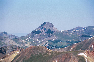
Uncompahgre
The Monarch of The San Juan, seen from Sunshine Peak on July 6., 2001.
Uncompahgre
seen from the ridge north of the basin. We skied to the
distinct notch just left of the peak.