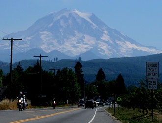
Mount Rainier
- Mount Rainier
- 4392 m
- Primary factor 4037 m
- Highest in Washington
- Climbed August 26, 2003.
Mount Rainier
|
|
Route description:
1. From Paradise to Camp Muir: From the upper Paradise parking lot (1650 meter, N 46:47.145, W 121:44.156), the best trail starts out to the left when facing the mountain. That is, to the left of the ranger station where you register for climbing. The trail is paved the first part of the way, signs pointing to Camp Muir and sometimes Panorama Point indicate the right way. The lower part of the Nisqually Glacier is visible to the left as you ascend along the very well developed trail. The trail climbs a fairly distinct ridge and splits as it nears the top, straight ahead is Panorama Point, while the trail to Camp Muir goes steeply left towards Pebble Creek. Somewhat higher, there is a good spot for a rest (Elevation 2100 meter, GPS: N 46:48.313, W 121:43.815) and shortly thereafter a final fork in the trail where you should stay left. This fork is approximately at 2130 meter. The trail continues flat, then even slightly down towards Pebble Creek. At this point there is a marked change, until now the trail has been at least one meter wide and well built. After Pebble Creek, the trail is really just what heavy use by many climbers create. The creek is easy to cross and most of the remaining route to Camp Muir is on snow, the well known Muir Snowfield. The route heads up on snow with more rocks on the sides. As you gain more elevation a very distinct triangle shaped (small) peak can be seen higher up. The route goes straight up just a bit left of this landmark (Anvil Rock). At elevation 2670 meter a distinct rock band breaks the snowfield. Hike up this in a shallow gully and exit left onto the snowfield above. The slope is now temporarily slightly steeper, but still easy to ascend. As the slope soon becomes more gentle, your course should shift somewhat more to the left. You should see a distinct rock ridge coming out with snow on either side. Camp Muir is up to the left (west) of this ridge. Be aware that what is called a snowfield up here is really a glacier. This section of the route is probabely completely safe and free from crevasses most of the season. However, when I hiked up at the end of August there was a significant crevasse crossing the field. When I hiked down about two days later, several more crevasses (all fairly narrow) had opened up. The slope increases slightly and soon Camp Muir comes into view. Camp Muir is really located on the saddle between a branch of the Nisqually Glacier and the Cowlitz Glacier. My GPS gave 3080 meter, N 46:50.132, W 121:43.941. There are a number of buildings, smell of human waste and tents typically on the Cowlitz side of the saddle. I found the place particularly unattractive. Thus my strong recommendation would be to either go on to the Ingraham Flats area or camp before Camp Muir on the snowfield.
2. From Camp Muir to Ingraham Flats:
Having arrived at Camp Muir, the next section of the route crosses the upper part
of the Cowlitz Glacier in order to reach the ridge called Cathedral Gap connecting
the route to the Ingraham Glacier. Below Camp Muir crevasses were the exception, above
they are the rule. All parties should travel roped. The precise route will change from year to
year, but typically the route will curve around gaining some elevation and work its
way west (left) of a rather large crevasse near the middle of the glacier. At the far end,
the route gets back on the ridge and zig-zags up to the ridgeline above. The last part
of this glacier crossing, before getting back to the ridge slope, seemed to be
somewhat exposed to rockfall. Be alert and move without stops. If you see a significant
number of rocks on or near your path then this is a certain sign that more may be on
its way. The ridge has elevation 3260 meter, and
location N 46:50.558, W 121:43.745.
As you look across the ridge, the route continues by a short traverse across to the edge of
the Ingraham Glacier. When I was there, this traverse was subject to frequent rockfall.
In fact, a good sized rock came down crossing my path about 50 meter behind me.
Climb (slightly steeper) up and onto the Ingraham Glacier. In order to reach the
Ingraham Flats area, the route traverses below the rocks on your left. Here, the danger
of rock fall was very significant indeed. Throughout my stay, small and large rocks came
down on this section of the trail. Move swiftly and without delay. The route
proceeds onto a section of the Ingraham glacier that is more level between
dramatic icefalls above and below, called Ingraham Flats. This is a very nice
place to camp, spectacular icefalls, big rockwalls, a view up towards the summit as well
as the impressve Cadaver Gap to the south-west. This camp site has elevation 3370 meter,
location N 46:50.711, W 121:44.048.
3. From Ingraham Flats to the summit:
The route typically climbs the Ingraham glacier on its left (south) side in order
to traverse above yet another spectacular crevasse. Then proceed horizontally
in order to reach the lower part of a large ridge that splits this glacier from the
Emmons Glacier further north.
This ridge is called Disappointment Cleaver and is the key to the route onwards.
The last part of this access across the glacier is scattered with
rocks from above, again look carefully then proceed with speed across to the ridge.
Indeed, I spent almost a full day at my Ingraham Flats base camp and noticed how
rocks at random intervals and in different quantities avalanched down in that
particular area.
Once on the cleaver, proceed cautiously across a first short section which is very
loose with poor prospects below you. Once protected (from rock fall) by a small
rock wall, put your crampons on your pack, they will not be needed for a while and
ascending the cleaver is certainly both easier and more secure without them.
The route continues as a traverse up and across the cleaver until you reach the
main ridgeline with a steep drop to the Emmons Glacier. Turn left and proceed
up along the ridge.
The route up the cleaver can sometimes be hard to follow if it is still dark, quite
soon after gaining the ridge the path comes across a distinct path that comes
up from the climbers left and continues ascending across the ridge to the right.
One should descend a short distance to the left, do not proceed
upwards at this point. Continue up the ridge, sometimes a bit on the left side. Show
extreme caution for climbers below, any small (rolling) rock could be very dangerous.
The Cleaver should be climbed to its very top, the last part is fairly narrow with
dramatic views down the Emmons Glacier. The top of the Cleaver was measured
to 3750 meter, and coordinates N 46:50.966, W 121:44.509.
From the top of the Cleaver, the route will certainly be different from year to year
and also depending on the time of year. In very late August after a warm summer, there
were huge crevasses further up blocking any direct route. The route therefore proceeded
on a long traverse above vertical ice walls onto the Emmons Glacier further north, see
picture below. This involved one crevasse crossing along a rather narrow ice ledge where
the professional guides had attached a fixed rope. After a zig-zag climb up the Emmons, the
route came to its crux at 4190 meter, location N 46:51.192, W 121:45.112.
an enormous ice cave with a very fragile and spooky snow bridge
in the middle immediately followed by a steep climb up the partly overhanging wall on
the upper side of the ice cave (see picture below).
Again, the guides (that make money getting climbers up)
must have carried out quite a bit of digging as well as fixing long ropes up the steep
section that followed the crux area. Clearly, such work makes the ascent easier also for
everybody else. It seemed likely that this route would not go for many more warm days,
I could see straight down into the enormous crevasse as I stepped onto the wall. A fall
here would be very bad indeed, hopefully the route is changed before that happens.
The rest of the route was comparatively easier as it gained the crater rim on its low side.
The crater is very shallow at the point of entry, only a little elevation is lost. Traverse
the crater and climb the ridge on the opposite side. Half way up, next to some sheltering
rocks are the summit register in a solid metal box. This place has
elevation 4370 meter, and coordinates N 46:51.211, W 121:45.558.
The route then continues further up the ridge
and gains a high point consisting of ice.
This is the highest point on Rainier, location N 46:51.174, W 121:45.624, elevation
4392 meter (My GPS showed 4400 meter). One can
continue along the ridge by first descending a little, then climb the highest rock point
a bit further onwards, location N 46:51.105, W 121:45.624. My GPS gave the same elevation
as on the snow summit.
Looking back it is pretty clear that the snow summit is indeed the
highest point.
Comments:
This climb came about in a somewhat unusual way. I was on vacation with my
family in Outback Australia (also climbing some mountains), when I got email
from The Colorado Mountain Club granting me a slot on their annual Culebra climb.
This was the only Colorado Fourteener that I had not climbed due to the silly
access restrictions. I had entered their lottery last year when I still had a few
remaining peaks to climb in the same area, but failed to get picked. Since then,
I had just decided to be content with "the ABC" (All But Culebra), as travelling to
Colorado from Norway just for this peak seemed unjustified.
However, for the first time CMC also had permission to climb Red Mountain, one of
Colorado's 100 highest on the same day. I figured that two summits was (slightly) better
than only one, what if I could combine this with another substantial peak and make it
at least three peaks in a short week?
Mount Rainier had been on my list of interesting peaks ever since I hiked the lower
parts of it with my wife Heidi and son Tor Erling (age 2) on my shoulders back in 1984.
I had heard it was pretty buraucratic, one needed permits, most people climb it using
professional guides etc. I sent some email out hoping to get some advice.
Andy Martin informed me via email that one could apply to get a solo climb permit.
I sent off such a request with reference to my mountain page and received (on the next
Outback Internet access point) a very friendly and positive reply from Drew Hardesty,
Climbing Ranger. He subsequently followed up with more help in order for me to start
the climb directly upon arrival at Paradise even though this would be after their
closing hours.
I spoke with two other (both female and good looking) climbing rangers on the mountain, they all
were very friendly and positive. I like to thank Drew and all the rangers for
a very professional and service oriented approach. They certainly do an important
job in the national park.
In 2003, entry to the park was 10 dollars, a climbing permit that I purchased
via the Internet in advance was 30 dollars. Additionally, one need to fill out
a climber registration form, one part is kept at the ranger station, the other
part is carried on the mountain and returned as you leave from Paradise.
I had a flight from Denver to Seattle on Sunday, August 24, rented a car and arrived at
Paradise around 1700. On my way up the mountain around 1730. One big disadvantage of
a solo climb is the heavy backpack. I carried what I considered important only, supplies
for a 3 day climb, but still
the pack was slightly more than 25 kg.
I climbed about as high as most tourists go (Panorama Point area) in about one hour, then
continued for 1.5 more hours up the Muir Snowfield. Pitched my tent right next to the
route on the snowfield just around sunset after 2.5 hours of walking from Paradise.
I had reached 2550 meter and camped at location North 46:49.220, West 121:43.544.
The weather
looked fine. After dinner I slept well and woke up around sunrise on August 25.
Started hiking at 0730, arrived at Camp Muir around 0845 and continued towards the Ingraham Flats
area at 0900, arriving there around 1000. I met several different parties coming down,
somewhat to my concern, except for a party of two climbers, they all said they had
been unsuccessful. Obviously, the rate of success was rather low just now, but I heard no
particular reason, perhaps general exhaustion was most frequently quoted.
I relaxed at my base camp for the rest of the day. It was tempting to set out and make it an
afternoon climb, that would eliminate all dangers from other climbers kicking rocks down
the Cleaver, however, the snow would be soft and both natural rock fall as well as seracs
and snow bridges would be more hazardous. I had been adviced in Colorado to make it essentially
a night climb, in order to avoid deep slushy snow. This seemed unwarranted as almost all
snow was melted away, what was left was ice and pretty hard snow. Unless absolutely
needed I do prefer to climb in daylight, after all one should see and enjoy the mountain
if at all possible. I got to know that the parties starting from Camp Muir tended to
start around midnight and pass my camp between 2 and 3. I made up my mind to start around 5 AM
the next morning.
The initial climb up the Ingraham Glacier went fine, I crossed the area with frequent
rock fall in a hurry, I had heard the regular sounds of rocks falling there throughout
the previous day. Once on the cleaver, I took off my crampons and adviced a party of
two climbers that came behind me to do the same. I ascended the cleaver without much trouble,
one dead end trail in the steep side facing the Emmons Glacier being the single mistake,
see the route description above. The two climbers behind avoided this as I returned,
however, there were climbers ahead of me on this wrong trail, they seemed to fail
the entire climb as I never saw them again.
An incredibly nice sunrise just after arrival on top of Disappointment Cleaver. The sun
was dark red as it climbed above the horizon to the east. Looking ahead on the
jumble of ice and crevasses, it seemed like a good idea to travel roped in teams of
minimum three climbers. The two behind me had arrived and I suggested that we join
on their long rope, our skills and speed of ascent seemed pretty compatible, we had climbed
independently, but more or less together for more than one hour.
Their names were Ben and James, thus we continued together from here to the summit,
hopefully with some level of improved security for both parties. (After having
climbed the route, due to the trail made by the guided parties, going roped did only
provide added security in a couple of places, in case one of the relatively few
snow bridges should decide on a sudden collapse.) In any case, they were good company
and we successfully climbed to the summit as the last party of the day, arriving on top
around 0930. We spent about 30 minutes on the top, the wind was very strong, storm force
in the gusts. One needed to bend down, and focus on balance in order to not fall when the
wind violently did its best to blow us off the mountain.
We descended down to the Cleaver, thanked for good company and split up. I returned to
my tent around 1200 noon. Had lunch and relaxed in the sun before heading down at 1400,
making Camp Muir at 1445, leaving at 1500 and hitting the parking lot (very tired) at 1700.
I travelled to Seattle, received a very warm welcome in the house of my friends Loyce and Randy
(and their 11 year old son Ben), before flying back to Scandinavia the next day, August 27.