How to get there:
Take Maroon Road (marked by sign) from the main
traffic circle just outside (north) of Aspen (On the main road, US 82, in
the direction of Glenwood Springs). The upper part of
this road is often (all summer)
closed to private vehicles in the period 0800 to 1700,
but any serious climber should be there much earlier so
this has little practical consequence.
If you intend to stay overnight in the Maroon Valley you may
drive up any time of day, a fee of US dollar 10 may then be charged at
the entrance station.
The road ends at
a clearly marked parking lot. We arrived when it was still
dark, had breakfeast in the car and started hiking at 0540, just
as the trail became visible. Route description:
The trail leaves the parking lot, runs along the flat valley floor,
then starts a gentle climb on the right side of the valley. There
are signs saying Crater Lake that should be followed. The slope eases
and the trail continues first flat, then gently down towards Crater
Lake. Before the lake one arrives at a fork in the trail and a big
sign with various information. The trail straight ahead goes to Crater
Lake and further onwards to the slopes of South Maroon. The trail to
the right has a sign saying Snowmass. This is the trail to follow, it
climbs gently for about one kilometer, then levels out and crosses a
small meadow. There is a cairn here indicating a (smaller) trail that
goes off to the left and quickly descends to the creek and crosses to
the other side. On the other side of the creek, the trail climbs
more steeply, but it is well marked by cairns. The trail continues
uphill, partly in the forest, partly on grassy slopes and partly in
an area of (smaller) rocks, making small zig-zags. North Maroon is
clearly visible and its north-east ridge is sharply seen as the
horizon.
The trail reaches a plateau and heads directly towards the steep ridge.
In order to get there one first crosses an area of boulders,
(Norwegian: "ur") that originates much further to the right and continues
at least partway down the slope to the left. On the other side, one
is on the mountain proper, the trail runs horizontally south along an easy,
grassy ledge. Right next to some small trees the trail abruptly turns
uphill, there is a large cairn marking this point. The trail climbs a
rather small gully that is blocked (nearby) uphill by cliff bands.
The trail bends further south (left) below these cliffs and enter what
looks like a rather large gully leading uphill. The trail crosses over
to the left (south) side of this gully and zig-zags uphill. The trail
is quite good and there is limited danger of loose rocks. It looks like
heavy use has cleared most of the dangerous rocks near the trail away.
Obviously, care is needed, one should keep an eye on any party higher up
and make sure that loose rocks will roll into the center of the gully
and thereby reduce any risks to hikers down below. Higher up, one can
clearly see the rock band described in the book by Gerry Roach. One can
further see the "crack" that provide a path through somewhat to the right.
However, after a traverse somewhat to the right (center of the gully),
the trail bends sharply left and contours below the cliff band, turns
around a corner (south) and descends slightly into a new, very distinct
gully. This route is not described by Roach, neither by Lamport, still it
seems to be the "de facto" route today.
Once in this new gully, the route again climbs up on the left (south)
side, the trail running in such a way as to minimize the danger of loose
rocks hitting parties below. Higher up, there are two choices. One can
continue up along what looks like a dry creek, there is a couple of
short, steeper parts where one need to use hands, however nothing
beyond class three climbing. This route will reach a more rocky
area with ledges and small cliffs in the very upper part of the gully.
Alternatively, one can traverse back
across the main gully to a small, distinct ridge that marks the
division between this gully and the top of the first, large gully
that the route followed further down. This ridge is mentioned in the
route description by Gerry Roach. His description assumes that one
stays in the first gully, climbs through the rock band there
and thus reaches this
ridge from the opposite side. In any event, from this small ridge, there
is a distinct ledge that further climbs into the very upper
part of our second (main) gully reaching the same area of rock
cliffs and ledges.
The route continues up, very well marked by cairns showing the
easier climbing, mainly class 2+ with some class three moves. The
route traverses quite far to the left before turning and reaching the
main crest of the north-east ridgeline. From here, the route continues
in a few switch-backs on the north side, now among looser rocks, but on
terrain that is less steep. The path leads quite directly into a V-shaped,
more vertical rock formation. A closer inspection reveals a very
distinct chimney, this can be climbed in essentially two moves,
first up and into the chimney, then a few easier steps and one should
locate a very good handhold about 35 centimeter in on the flat top
of the rock to the climbers right. Thus, this final move is indeed quite
easy. This short chimney is still the technical crux of the route.
Further up, one arrives back on the main ridge, this time on a very
flat, section with a considerable drop on the climbers left. One is
now in the very final section of the ascent. The next rocky outcrop
has cairns indicating routes on either side, however, the easier
route is on the right (north) side. From here, the trail is quite easy
leading up to a very nice summit plateau of quite reasonable size.
Unless one continues the traverse across to South Maroon, one should
carefully follow the same trail back down. It is easy to make a wrong turn
and find more difficult, dangerous terrain. Comments:
I did this climb with Jan-Frode Myklebust. We started
at 0540, I made the summit around 1045, we left the summit at 1135
and were back at the car at 1500. On the way up, we met a female
climber just before crossing the rocks to get onto the mountain proper.
She had spent the night there with a sprained ancle. A rather large
rescue party came up while we were on the mountain and got her
down. It was told that this was her last fourteener, what a way to
finish climbing 54 peaks.
Resources:
Images
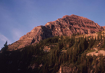
North Maroon, the route runs in two gullies just behind
the ridge, gaining the ridge higher up.
South Maroon, as seen from the lower part of North Maroon.
In the second (last) gully, people can be spotted in two different
locations. It is steep, loose rocks are abundant, the cliff bands
higher up look hard...