How to get there:
A good starting point is the village Chamonix, not too
far from Geneva. Route description:
Day 0, we established
Base Camp in a park in Chamonix.
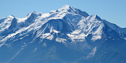
Day 1, We started from Les Houches, a bit west of Chamonix. The first leg
was a hike on a nice trail up to a place called Bellevue at
approximately 1800 meter. Soon therafter one can see
Aigue du Gouter, the goal of the
first day, as the highest point on the horizon.
The next place along the route is called Nid d'Aigle (eagles nest)
at 2372 meter. One can take a
cable car to this point, however,
we climbed the mountain from the valley floor.
Above Nid d'Aigle
the view is getting ever more
impressive.
The trail is good as we climb to
the next mountain hut, named Refuge de la Tete Rousse at 3167 meter.
The first ice and spectacular
scenery around Tete Rousse. Shortly after this hut, one arrives
at
Le plus dangereux de la route !!,
a gully (Le Grand Couloir, 3270m)
with constant danger from rock fall. Look left, listen
carefully, then cross without unneccesary delay.
Refuge de l'Aig du Gouter,
3817 meter is now straight up. This is a crowded, but very good
place from which to climb Mt. Blanc, starting out quite
early in the morning. One should call the hut and make an advance
reservation. The scramble up here is fun with solid rock and
good ledges, however some people are scared by
the height.
Day 2, We started
dead last
(the first parties left around 0200) as we
had no lights! (in Norway, mountains are climbed in the day, very
seldom at night.) An early start is essential since the weather
tends to be better in the morning and since one should be off
the mountain well ahead of possible (and frequent) lightning
in the afternoon. The route is on snow all
the way.
Rope for normal glacial travel, crampons and ice axe, there
is no climbing along the route.
The route first climbs
Dome du Gouter, 4304m, then there is a
small loss of elevation (about 50 meter), before the route climbs
to
refuge Vallot, 4362m and more
steeply along the top of a ridge to
Les Bosses, 4547m.
The route continues
uphill,
one may feel the thin air, but the summit is now quite close.
The last
ridge and
the summit is ours, Italy
is in the background.
On
top of the world, as
we descend carefully. The 4052 meter Aigue de Bionessay is
in front of us below.
Mount Blanc, as
seen from the top of Dome du Gouter, refuge Vallot below
in the foreground.
I look at a more difficult peak,
Aigue de Bionessay, 4052 meter.
Returning from a perfect day,
Chamonix below and
Refuge de l'Aig du Gouter straight
ahead. We returned all the way to
Chamonix the same day. From here
one can see most of the route. Comments:
I did this climb with my friends Jostein and Sverre. Despite
starting dead last sometime after 0400, we hit the summit at 0730
after a bit more than 3 hours. We overtook almost everybody else
on the way up, so the normal time up must be substantially more.
Mt. Blanc is a fantastic mountain in good weather.
As the sun rises one has a scenery of exceptional
quality, large glacial icefalls and sharp ridges to
secondary summits.