Barre des Écrins
- Barre des Écrins
- 4102 m
- Primary factor 2045 m
- Location: North 44:55.328, East 006:21.574
- Location: South-East of Grenoble, France
- Attempted July 13, 2009.
- Climbed May 23, 2010.
- Difficulty: YDS class 4, French Alpine PD+ (icy conditions)
- Photo credit: Helge Larsen (photos starting with "2xx".)
|
|
Information:
How to get there:
The nearest big cities are Grenoble, Torino and Geneve, the latter two having international
airports. The closest city of some size is Briancon, near the Italian border. The distance from Geneve
to Briancon is about 250 kilometer and about 3 hours of driving.
From Briancon, drive south on Hwy. N94, and fork right onto Hwy. D4 (signs for Pelvoux/Vallouise) after approximately
7 kilometer. After 11 kilometer, you should go more west and north-west, leave D4 and follow signs for Vallouise.
Continue up the valley, drive past Vallouise and to the very tiny place called Ailefroide. From here, a paved, but
narrow road continues up the valley to a large parking area named Pré de Madame Carle (about 5 km beyond
Ailefroide). Park here, this is the trailhead. Location N44:55.010, E006:24.912, elevation about 1880 meter.
There are a couple of hotels in Vallouise, and perhaps more modern lodging up at the ski area called Puy-Saint-Vincent.
We stayed at this place, the road there forks left just before entering Vallouise from the south.
Route description:
To the huts:
This is a very popular area, expect a lot of people at the height of summer and on most weekends. The trail heads north
from the parking, crossing a river on a nice
bridge. This trail is wide and
well developed pretty much all the
way to the first main hut, the Refuge du Glacier Blanc. After a few switchbacks, you arrive at a trailfork. The left
fork leads up along the top of a moraine to Glacier Noir, our route forks right and continues with zig-zags climbing
the face in order to reach a shoulder further up.
From here, turn the corner and descend slightly to the river that can be crossed on a sturdy bridge. Next, the trail
becomes slightly steeper as it gains the shelf above before heading more directly towards Refuge du Glacier Blanc.
This refuge is located on top of a nice cliff, obviously commanding an excellent view back down the valley. The trail climbs
the lower slope, then ascends up and left of the cliff before a final, short (steep) uphill to the hut.
This location is N44:56.242, E006:24.698, elevation 2560 meter. The refuge phone is +33-(0)492235024.
It is possible to stay at Refuge du Glacier Blanc, however, this makes for a long summit day. Most people try
to get reservations at the highest refuge on the route, the Refuge des Ecrins about 600 meter higher.
From Refuge du Glacier Blanc, head uphill along a fairly well marked trail (there are some variations). Higher up,
the trail traverses high above the glacier in such a way that the route connects with the permanent snow along the
edge of the glacier, as soon as the glacier has a more gentle slope. Continue on snow along the right hand side of
the glacier, then gain the main glacier which is now pretty flat, and proceed until more or less below the refuge.
You will then be at location N44:56.716, E006:22.884, elevation about 3080 meter.
The refuge is situated high above the glacier
on a cliff (the picture is taken in the opposite direction).
Thus the final ascent is somewhat steeper and one will need to
descend this section before proceeding to climb Barre des Ecrins.
The refuge phone is +33-(0)492234666.
To the summit:
The route continues along the almost flat glacier in an obvious way.
Just a bit beyond the Refuge des Ecrins, the glacier has a gentle uphill section and
already here you may find some pretty serious crevasses. One should travel in teams and use a rope
for safety.
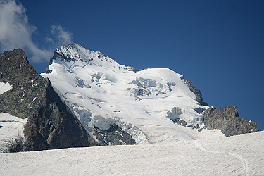
Further in, the big and pretty impressive
icefall from Barre des Ecrins comes into view.
The normal route used to swing right towards a distinct col,
then do an initial ascending traverse towards left
(when viewing uphill), however, the danger of
serac fall has led to an alternate route
that climbs the lower section more directly head on. With this route, the lowest section
of the big slope also becomes the steepest part.
Follow the well established track as it zig-zags up the icefall. There are quite a few
crevasses, but they tend to be pretty easy to
detect. Higher up, the route will reach
a somewhat more level slope that
can be traversed (going right) until one arrives below the
col named Brèche Lory. This last pitch can be steep, one may also have some trouble with the crossing
of a bergschrund that runs pretty much at the same level.
From here, one either continues up and across Pic Lory, this
is the normal route to the main summit.
The access to this ridge may cross an icy section. This first
part is the crux of the climb. If the
conditions are a bit unfavorable, this pitch requires ice screws and proper belays, ie. proper
climbing.
If one turns
right, it is an easy matter to climb the subsidiary peak
called Dome de Neige des Ecrins at 4015 meter.
Comments / Trip Report:
1st. Attempt, July 13th 2009:
We arrived in the Vallouise valley on July 11th. and
quickly decided to establish (family) base camp in the ski area Puy-St-Vincent.
On July 12th, we first made a family hike to
Tète de Orlac, 2093 meter. A very nice viewpoint, a beautiful mountain
towards the west, and the eyecatcher, Mont Pelvaux, 3943m, due north.
Perhaps even better, a very good view of the Vallouise village, and
the general landscape at the base of the Ecrins National Park.
We continued down to the local saddle and established
that our local mountain had a prominence of approximately 89 meter.
We were unable to get any reservations on Refuge des Ecrins and settled for the next best, a reservation
at Refuge du Glacier Blanc. We started out from the trailhead at 1530 and made the hut by 1710.
We immediately were faced with several unfavorable conditions. Upon arrival, Pål Jørgen and I
noticed an attack of a stomach bug.
I needed a toilet, while Pål did not feel like eating anything.
The result was pretty much the same, little or no energy reserves for the next day climb. We talked it
over and agreed to still make an attempt the next day. The other issue was our starting point almost 2 hours
below the ones that started at Refuge des Ecrins. We ordered a pre-arranged breakfast by 0130, aiming for
a departure at 0200.
Waking up on schedule, we went downstairs only to discover that the breakfast had not been prepared.
Not good, but we did carry some bread and salami that could be used as an emergency substitute.
We left at 0205 and made good progress up the slopes and onwards on the glacier. Ascending in the dark,
we noticed that we were the only party trying to climb Barre des Ecrins with a start from Refuge du Glacier Blanc.
We arrived below the Refuge des Ecrins around 0330, noticing that a few teams had already started, while the
majority were still desending from the refuge to the glacier.
We roped up and continued towards the steeper part of the glacier further ahead. The route stayed left and
climbed the steeper slope head on. This is not the normal route, but as the alternative seems increasingly
more dangerous due to the seracs above, the
route had been changed. It felt steep and I wondered how it would
be to descend. Higher up, the
slope eases somewhat, but there was a pretty frequent pattern of new crevasses that
had to be crossed. As we ascended the upper part of the glacier, the sun started to show in the east. We reached
Brèche Lory well
before 0700 with only one team ahead and a second team right behind us.
Big surprise! In order to access the ridge, one needed to traverse a pretty steep and completely icy slope.
The entire approach looked pretty nasty. I had read that this route should be no more than UIAA II, a friend
had also told me that the climb was not much more than a pretty straightforward scramble. Hmm. what we observed
did definitely not look straightforward. The team ahead decided that belayed climbing was needed, the team behind
us came to the same conclusion. They went ahead to establish
a secure belay stance by the use of good
ice screws.
Trouble was that we only carried a short randoneé rope, no ice screws and really no gear (biners etc)
for a pitch of real climbing. We considered the situation for about 15 minutes while watching the difficulties
of the first two teams. Pål Jørgen and I were in full agreement, this was not a pitch that
we could tackle with the required safety given our equipment. Too bad, after such a good effort, we being the
only team that started from Refuge du Glacier Blanc. Having overcome our
stomach problems, lack of breakfast, having climbed the
steep glacier among the first teams etc. The weather was cold and windy with dark clouds, quite different from
what one ideally should have around 0700 in the morning. We both needed our jackets and gloves. The decision
was easy, we took a long
look at the summit cross, close but out of reach, then
turned and climbed Dome du Neige des Ecrins without any further problems. Clouds were drifting around,
but the views were still nice. The nearby, somewhat lower terrain is quite
rugged with sharp peaks scattered around.
We had reached Col Breche Lory around 0645, left about 0700 and arrived at the subsidiary snow dome summit by 0715.
We enjoyed the views and landscape until 0730 before heading back to Breche Lory in order to start our descent.
More teams were arriving, but most teams went directly for Dome du Neige without even considering the route leading
towards the main summit.
The descent went quite smoothly without incidents and the weather also improved greatly. The sun started warming, blue
sky appeared and the clouds vanished. We made a long break at
the flat area below the glacier and in a safe distance
from possible ice falls. The scenery was dramatic and Pål Jørgen expressed his approval repeatedly. This
was a true alpine place, the glacier was a real, substantial glacier, the peaks around were all good peaks etc.
We continued our hike around 1000, and
arrived back at Refuge du Glacier Blanc by 1145. Another long rest here, the
weather was now perfect and the place was pretty crowded by day tourists from the parking area below.
This is indeed a nice destination
overlooking the valley below and with a good view to the receeding
end of Glacier du Blanc.
Perhaps even more impressive, the Mont Pelvoux, 3943 meter,
right across the valley.
We left at
1245 and hiked down to the car, arriving at 1405.
Including ample rests, we had been on the move for 12 hours. Great
to take the boots off and drive back to Heidi where a late lunch by the swimming pool carried our near future.
We had learned a lot about this mountain and the route. Next time, when we return, we shall carry a climbing
rope and enough gear to take the time required to access the ridge of Pic Lory.
2nd. Attempt, May 23rd 2010:
A three day weekend (with Monday being a holiday), called for some action in the Alps.
My friend Helge wanted to come along and my son Pål Jørgen completed our
group of three.
We flew to Geneve in the afternoon on Friday. With several hours of connect time in
Amsterdam, we decided to travel to the city center and have dinner there. After getting
round trip tickets from a machine, I asked a lady in an information boot about trains and she
said: "The first train leaves in less than 2 minutes from track 3", we scrambled across and
downstairs and jumped on the train as it was about to leave. In doing so, Helge mentioned
that he had seen a sign saying that the train did not stop in Amsterdam? Well, too late to worry,
the train looked promising as it stopped on a couple of stations in the outskirts of Amsterdam, but then continued
directly to the city of Utrecht! We got off at Utrecht and quickly located a train that took
us back to Amsterdam. Nice dinner at an Argentinian restaurant. The journey continued without
further incidents and we stayed at a small, inexpensive hotel just south of the border
to France. The next morning, we started driving around 0815 and then discovered that the mountain
pass Galibier was still closed by snow. We quickly decided too drive through the tunnel on E-70 leading
into Italy. Euro 40 in toll for a return ticket, this road was quite ok and we got back into
France across a smaller mountain pass and then to the city of Briancon. We passed the small place of
Ailefroide and got up most of the hills before
the road was closed by snow perhaps one kilometer
before the parking at Madame Carle. We parked along the road in an area full of parked cars around
1145. The location was N44:54.658, E006:25.838, elevation about 1829m.
Leaving at 1215, we carried the skis up the
first hill and found permanent snow just as the trail
reached the shoulder that leads into the basin below the first Refuge du Glacier Blanc.
From here, we skied directly up a somewhat steep gully that tops out just behind the refuge.
From here, we had a good view further uphill to the glacier that
is accessed via a climbing traverse on its right hand side.
Leaving the valley behind,
we now get onto more gentle terrain and
as we gain elevation, the final part comes into view with
Barre des Ecrins as the final stop.
From Refuge du Glacier Blanc, the route is similar to
the summer route.
We arrived at the Refuge des Ecrins around 1700 after a very nice climb on skis.
Getting up at 0400, we were down at the glacier and ready to ski by 0520. We skied the same route
as we had walked previously, rather
steeply up
the middle in order to avoid the serac danger that
exists if one follows the "normal route" that traverses right to left up a somewhat more gentle slope.
The sky had scattered clouds, but also sunshine and no wind. We (at least I!) skied rather slowly and
it took time to reach the traverse just
below the summit rocks and the big crevasse that runs parallel
just at the upper end of the glacier. There was only one crevasse further down with a solid snow bridge
in the middle. We located a snow bridge crossing the crevasse just below Pic Lory, thus providing access
to the (steep) slope that leads up to the small col between Pic Lory and the main ridge of Barre des Ecrins.
In this variation, one avoids the first section of climbing that starts from the col Brèche Lory.
However, this slope was icy under a thin layer of snow and required 45 meter of belayed climbing in order to reach
the main ridge. We similarly used the rope and a rappel on our return when descending.
We proceeded to climb using running belays along the ridge. This ridge first leads to a false summit, then slightly
down before ascending gently to the cross at the main
summit. The section just before the false summit is
very narrow and
has great exposure. For about five meter, the ridge is only about one centimeter wide, providing
good handholds as you climb along its left side. We stayed exactly at the top of the ridge all the way to
the summit with mixed conditions. Snow and ice in combination with rock pretty much all the way.
It is possible that this route looks a bit simpler under dry summer conditions. No big difficulties,
but a long and sharp ridge (photo from summit) that
required our full attention. I would rate the climb as a pretty hard
(YDS) class 4 route, corresponding to a PD+ rating on the Alpine scale.
The ridge climb required a couple of hours and we arrived at the summit at 1145. Another team had climbed the
face directly to the summit. They were busy setting up the first return rappel from a big rock at the very
ridge, this resulted in some minor traffic jam in an area with limited real estate. Unfortunately, we had a local
cloud descending on the summit just as we were there.
The views to the north and east were still fine.
Since a lot of time had already been used, we started our descent around 1200.
Carefully retracing our steps
we got back down to the skis and a rather long and steep downhill slope.
We returned to the refuge at 1645, a long day, we were all
pretty exhausted and needed a rest before dinner at 1830.
We stayed a second night, got up at 0600 on Monday and started
our descent on skis around 0700.
The day was perhaps even better than yesterday, Ecrins is glowing in the morning light.
This return trip
was pretty uneventful, the weather was absolutely brilliant and
we all had a good time before reaching the car
around 0930. We started driving by 1000 and stopped for a nice lunch in Aix-les-Bains before hitting the
airport in Geneva around 1600, about
two hours before our flight at 1800. No more to report, we landed in
Bergen around 2230 all with memories of a very successful weekend trip to the Alps.
Resources:
- Images, 2009:
- Images, 2010: