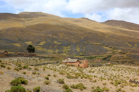
Cerro Wila Chanca

  • Cerro Wila Chanca
  • 4701 m
  • Primary factor 771 m
  • Location: Poopo, Bolivia
  • Location: South :18:25.213, West 066:56.375 (GPS on the summit)
  • Saddle: (3920-3940), 5 km SE of summit, La Pampita.
  • Climbed: December 28, 2010.
  • Difficulty: YDS class 2.

Information:

How to get there: From La Paz, travel south on Hwy. 1 to Oruro and continue further south along Hwy. 1. Between Lago Uru Uru and Lago Poopo, locate the exit east to the small village of Poopo. Drive through town and find the road that runs near the river in the bottom of the gorge that cuts through the mountains going east. drive to the east side and keep right, ie. fork south as the road follows the river Poopo. Continue south and look for a few small, local farms near the base of the mountain on your right (west) side. There is a small access road that will take you to a suitable trailhead at location S18:25.286 W066:54.678, elevation about 3980 meter. Park here, exchange a few friendly words with the local farmer, then set out uphill.
Route description:
Head uphill and pay attention to various deep gullies and or ravines that cut into the hill as they run down slope. Cross these where convenient while maintaining a line of ascent that bears right (north) as you traverse steadily uphill. A suitable waypoint partway up this slope may be S18:25.413 W066:55.860, elevation approximately 4490 meter.
As you get higher, gain the crest of the mountain just south of the south summit, then follow this easy ridge to the south and highest summit.
The summit has a trig. point marker and provides a good view all around. Note that it appears from the map that the north summit should be higher. This is, obviously, incorrect.
From the south summit one can descend directly into the saddle S18:25.104 W066:56.380, elevation about 4613 meter, before climbing the north summit at S18:24.965 W066:56.508, elevation about 4690 meter. This summit has a good view of the village Poopo, as well as west and back towards the slightly higher south summit. There is a trig. marker on this summit as well.
Return to the saddle and traverse back down to the trailhead.

Comments / Trip Report: I made this climb with Rob Woodall and Adam Helman. We started out around 1045 and made the south (main) summit about 2 hours later, at 1245. We rested and looked around before traversing to the north summit around 1330. Looking south to the first summit, it was pretty obvious that this was indeed the highest. Later, on descent, we "lost" Rob behind and spent about one hour looking for him before we continued downhill. Not surprisingly, but very welcome indeed, we reconnected with Rob back down at the cars. He had deviated from our route, then reconnected with our line of ascent. A lesson learned about the importance of not getting separated without a clear understanding of where people are going. Adam and I returned to the trailhead around 1600.
We continued our drive to the village of Challapata, where we found a nice and charming hostel for the night.
A summary of peaks climbed are available. A full trip report can also be consulted for more pictures and additional details.

Resources: