Mount Boising
- Mount Boising
- 4150 m
- Primary factor 3709 m
- Location: South 5.95373, East 146.37526 (GPS on the summit)
- Location: Highest in the Finisterre Range, Papua, New Guinea.
- Climbed June 25. and again on June 26., 2014.
- First and second ascent.
- Difficulty: YDS class 3.
|
|
Information:
A more detailed and exstensive
trip report will be written. (Please check later.)
The local people do hope that a small scale ECO-tourism may be established
in order for more people to experience the unique nature and culture of this
region, as well as being able to climb this fine peak in a somewhat more
structured manner. Our ascent established a trail that now connects the mountain
with the local village trails. The local people discussed creating a second trail
in order to offer two alternative approaches to gain the main ridge in the future.
More information about this will follow later.
A short summary of our 2014 climb
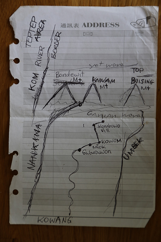
The peak name:
One of the three heads of the "Clans" that are "Landowners" of
this mountain, drew small map by hand
where this name (Mount Boising) appeared. The other two "landowner" clans are in
full agreement. It became clear from my visit over 2 weeks that
this name is "widely" used and accepted to mean this peak among
about a local population of perhaps 2000 people. In this context, It is
interesting to note that the peak itself is actually visible from the
village of Gwarawon, the by far largest village in the Nankina
tribe area. Thus, the need for a name is pretty obvious.
The name is supposed to mean "stop the fight". The legend tells that the (lower)
mountains on either side started "a fight". There were earthquakes and landslides,
finally Boising decided to stop it all - and everything became again quiet.
The peak location:
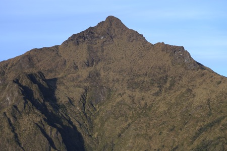
The summit area consists of a pretty sharp (short) ridge with
considerable drops. We built cairns at each end. There is a
small hump along this ridge that may be about the same height
(as the high end). The other end is clearly lower.
The main cairn was built on what appears to be the natural
high point of this short ridge. This location is:
SOUTH: 05.95373
EAST: 146.37526
My best estimate based on measurements on 2 different days,
is (conservatively) that
the elevation is 4150 meter. (GPS readings of 4151 and 4155)
I would be highly surprised if this is more than 5 meter off.
The Garmin itself typically said its accuracy was in the
range +/- 3 meter. One should double this to get vertical
uncertainty. The Google Map contours are not accurate, they
show a rounded summit area.
The first ascent:
The first ascent was made on June 25th at 1410 (local time)
by a party of 5 with my son Pål Jørgen
leading the route-finding up the (north) ridge. We all held hands
and stepped onto the summit together:
Petter E. Bjørstad, age 63 from Norway
Pål Jørgen Bjørstad, age 25 from Norway
Wionare Mitimu, age 45 from Gwarawon
Nathan Hone, age 38 from Sawan
Roinu Roipo, age 38 from Kwombwu
We started at 0820 and we returned to Sapsap around 1700. This trip included
a significant amount of time to clear a path through very dense vegatation.
On June 26. the climb was repeated, this time by
Petter E. Bjørstad, age 63 from Norway
Pål Jørgen Bjørstad, age 25 from Norway
Barbara Hodgkinson, age 54 from Australia
Borisinu Oriro, age 24 from Kwombwu
We started at 0745, summit at 1245 and reached camp at Sapsap at 1645, a 9 hour effort.
This climb was significant, as it broke a TABOO among the
natives, that NO woman should even approach this mountain area.
The belief was that this would (certainly) lead to her death. The chiefs in
two different villages debated this for many hours and finally
approved, under several rules that we followed. Barbara has
lived in a Papua village as the only white for more than 20 years,
she walks around barefoot and is quite well known back down in
Gwarawon etc. Thus, it was very appropriate that
she became the first woman to climb the highest peak in the Finisterre Range.
Here is a GPX track from my GPS, showing our exact route from the village of Gwarawon:
(Note that the map is a bit cluttered by tracks that are just straight lines, however, the navigation
menu allows to examine individual tracks as well as hiding tracks that are of less interest. Please contact
me if you have questions related to this.)
How to get there:
The Finisterre Range is located in Papua, New Guinea. The range
separates the coast known as the Rai coast from the Ramu valley.
The best point of departure for this mountain is the town of
Madang, located across from the Rai coast.
International flights from Australia and Singapore serve Port Moresby,
the capital of Papua New Guinea (short is PNG), this is the only city
with international flights. There are scheduled domestic flights connecting
Madang and Port Moresby.
Madang has several options for lodging. The high end is Madang Resort, but
there are also a few smaller hotels and guesthouses that will provide
accommodation. Madang has a supermarket and several banks with ATMs that
accept international bank and credit cards.
Route description:
Here is an outline of a 2 week trip. Clearly, some variations are
possible and even likely to happen. However, after our initial trip where
a substantial effort was breaking/establishing a trail, this trip can now
be planned as a two week effort. This schedule assumes that all participants
are in good shape and able to walk on difficult trails for full days.
Day 1. - Take a dinghy from Madang to Saidor.
Day 2. - Walk from Saidor to Yongem.
Day 3. - Walk from Yongem to Gwarawon.
Day 4. - Walk from Gwarawon to Kwombwu.
Day 5. - Walk from Kwombwu to Ganzewit, on the main ridge.
Day 6. - Walk from Ganzewit to high camp at Sapsap.
Day 7. - Climb Mount Boising, return to Sapsap.
Day 8. - Return to hut (Kuruka garden) above Kwombwu.
Day 9. - Short day to Kwombwu.
Day 10. - Walk from Kwombwu to Gwarawon.
Day 11. - Rest day (or reserve day) in Gwarawon.
Day 12. - Walk from Gwarawon to Yongem.
Day 13. - Walk from Yongem to Saidor.
Day 14. - Take dinghy from Saidor to Madang.
This schedule has one full reserve day (day 11) that may be used to handle
unforseen complications. Rough sea may delay the crossing of the bay with
the dinghy, really bad weather could postpone the summit day etc. In addition,
the schedule as outlined contains a bit more flexibility. If one arrives by
noon in Saidor, one may walk up to the village Wesan that day and possibly (strong
party) reach Gwarawon the next day. Similarly, one may descend all the way from
Sapsap to Kwombwu in one long day.
A one week trip is also possible, provided that one is able to charter a dependable
flight (small airplane) round-trip from Madang to Gwarawon. My experience with two
such airlines, MAF (Missonary Aviation Fellows) and SIL (Summer Institute of Linguistics),
is rather negative. They
are not (as of 2014) professional. They do not stand by agreements and may fail
to honor definite plans on short notice. (Read about this in my trip report.)
The price for a charter flight
is also at least twice
as expensive as a similar bush charter in for example Alaska.
This situation may possibly improve in the future.
Still, it should be noted that there is a lot of quality in actually hiking from the
very coast with coconut palms and a sandy beach, all the way across the different
vegatation zones to a 4000 meter peak. This way, one gets to experience the trails that the
native population has walked for centuries, one sees and sleeps in the small local
villages and learns a lot about both nature and people, highly recommended!
Comments / Trip Report:
This peak was known to be the only unclimbed peak on the list of the 50 most
prominent mountains in the world. Very little information existed, the name was not
known outside the Nankina tribe. The peak was just known as the highest point in the
Finisterre Range.
My son Pål Jørgen and I first tried to climb this peak in June 2012.
We failed to reach our goal for a number of different reasons, but gained a lot of
valuable experience.
Trip reports describing
our 2012 journey
as well as the
successful expedition in 2014 will be available towards the end of 2014..
Resources:
- Images
- Summit picture,
Left to right: Roinu Roipo, Wionare Mitimu, Nathan Hone, Pål Jørgen Bjørstad (in front).
- Summit picture,
Pål Jørgen Bjørstad and Petter Erling Bjørstad.
- Barbara Hodgkinson, on the summit. This picture also shows the top summit
ridge rather well. We built the small cairn that can be seen at the very end.
- Mount Boising, as seen from Gwarawon.
- Mount Boising, as seen on our trip in 2012.