Location: South 03.04881, East 035.82071 (GPS at the summit)
Difficulty: YDS class 2
Climbed January 11. 2019.
Information:
How to get there:
First, drive the nice and paved road that connects Arusha with Ngorogoro.
After entering the park (possibly one of the most expensive in the world?),
drive to the crater rim, where there is an official viewpoint. At this location,
turn right onto the crater rim road. Continue to location
S03.02668, E035.68519, elevation about 2660 meter, where one may camp.
To get to the trailhead, continue to drive on this road as it enters a large basin.
There are many Msai huts along the lower slope of the mountain. We drove to
location S02.98672, E035.80247, elevation about 2560 meter.
The crossing to the mountain side of the drainage was not attempted due to
recent rain. One may, however, turn right shortly after entering the huge basin,
then drive around fairly close to the distinct slopes and arrive at the
Masai huts on the lower mountain slope in this way.
Route description:
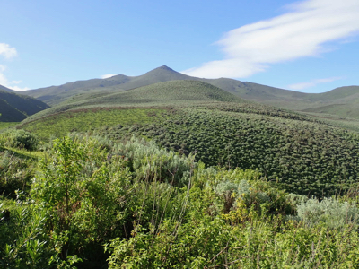
The shortest route proceeds up the slope towards the very pronounced
peak that is at the end of the summit ridge facing the basin. In the beginning,
one should follow trails made by the local people looking after their cattle.
Higher up, there seem to be no clear trail, but many animal tracks that
may be followed while keeping the overall direction. As the slope steepens,
one should follow a line on the left (when looking uphill) side of the
peak. This will easily lead to the main summit ridge that can be followed
to the highest point, located at the far end.
Comments:
We drove from Gelai Bomba around 0800. With some stops along the way, including
a flat tire, we arrived at the National Park Entrance around 1400.
Before then, we made a stop at an official center selling all sorts of Tanzania/Masai
crafts to tourists. I bought a small bowl with lions, mostly because I think the
colors will match our redwood table. Soon thereafter, you come to another similar
(but slightly less fancy) tourist shop. This one has no preset pricing (unlike the first
one). I asked the price for an item that looked identical, and the quote was about twice
as expensive. However, in this place one may bargain and most likely end up with
a pretty similar price.
In order to
get to our campground, we still had a pretty long drive along the crater rim.
A nice campground with a masai watching for lions, estabished around 1600.
The climate here is very agreeable,
just like a Norwegian summer day.
We had a good chat with our local Masai guardian, then the head ranger
William, showed up and we continued the good conversation.
We next had an excellent dinner (as always!) prepared by our cook Geoff.
After dinner I briefly met with ranger Steve, he would do the climb
with me the next morning. We agreed on breakfast at 0630, then leaving
at 0700. Early to bed with some light drizzle.
Breakfast at 0630, we left around 0715. A big group today, a masai guide with his
spear, a park ranger with an automatic (big) gun. Then Geoff also wanted to join us,
he had never climbed this peak before, it is number 3 in Tanzania and he had been
numerous times on the two highest. Perhaps typical that this turned out to be my first
peak not seeing any dangerous animal, while I encountered buffalos on my first two
ascents, but then with no spear nor gun.
We started hiking at 0750, about one kilometer short of where Rob started, since we could not
drive across the gully to the masai villages on the mountain side of the terrain.
Our guide decided to take a route that ascends a very distinct valley that separates the main
summit from a lower summit on the east side. However, it soon became clear that this
valley was a poor choice due to dense vegetation. He informed me that after more dry periods
this valley route is indeed very easy.
We climbed steeply out of the valley to the east!, wrong side of the valley if we intended
to climb our target mountain anytime soon. The bonus was more wildlife, we spotted several
groups, as well as a few large ones, more isolated.
We proceeded up the slope ascending parallel to the vally on our right. There were some
trails, but also bushwack mostly among burned branches. Finally, as we approached the
pass where the valley would end, we came onto what looked like an old, frequently travelled
path, clearly improved by people. Following this to the main saddle, located at
S03.04334, E035.83374, elevation very close to 3400 meter, it seemed that we could ascend a broad
ridge that would connect with the summit ridge. However, my masai guide now suggested that
we should descend into the valley on the opposite side, not far below, this valley
had a rather larger, flat section covered by grass. I politely resisted this suggestion,
saying that my purpose was indeed to climb the mountain. The masai then went on trying to
explain that this flat area below was a place of special significance to the masai people
and that it indeed had given the name to the mountain. Very well, but I still asked that
we skip even more detours (even loosing elevation) and proceed to climb the mountain.
We had already made a route far longer than neccessary as far as I could judge.
The masai, somewhat reluctantly, accepted my wish and we proceeded uphill, gaining the summit
about one hour after getting to the saddle. The time was 1150, the ascent had taken us
4 hours. We stayed at the summit 20 minutes, then descended using what seemed to be
the most natural route. We were back at 1400, so less than 2 hours. Ascending this way
would have been much easier than the route we had followed.
The previous peak on this trip was Kitumbeine,
the next peak is Hanang.