Grosser Geiger
- Grosser Geiger
- 3360 m
- Primary factor 295 m
- Hoher Tauern, Austria
- Location: North 47.09315, East 012.30867 (GPS on the summit)
- Difficulty: YDS class 2
- Climbed April 21. 2018
Grosser Geiger
|
|
How to get there:
The starting location is the small village named Neukirchen am Grossvenediger. This town
is located along Hwy. 165 going west from Mittersill. You get to Mittersill by travelling west on
Hwy. 168 from Zell am See. Zell am See, in turn, is reach via Hwy. 311 going south then west from
Bischofshofen. Bischofshofen is near A10 south of Salzburg.
As you travel west from Neukirchen am Grossvenediger, turn left only a few hundred meter after
leaving town, on a smaller road serving Sulzau. Pass through this tiny farm community, heading for
the valley that exits towards this plain. Turn right and cross a bridge (the river), then head
left (south) as this forest road climbs into the valley.
In April, the road was closed already at location
N47.22382, E012.24481, elevation about 940 meter, where there is limited parking on the left side.
This is just opposite the location of a small quarry.
Note that later in the season, there are more transport options, see below.
Route description:
Hut climb:
First, follow the road to the border of the national park. There is a good sized
parking lot here. Thus, later in th season (mid May?), one may drive to, and park
here. This location is N47.19330, E012.26182, elevation about 1300 meter.
Later in the season when the road is ok further up and into the valley, there is
a taxi service that have permission to drive people a lot closer to the
Kürsinger hut.
In winter (spring), the route follows the road and there are two distinct
uphill sections in this valley. After the first uphill where the road
climbs in zig-zags, a more level section follows and one arrives at the
Postalm hut. This is a good starting point for a climb of Grosser Geiger.
Next, the valley has another step before you enter the last, more level
section that runs below the Kürsinger hut. One follows the valley
to its very end where a steeper section climbs to reach a very distinct
(glacier) lake. The glacier used to be here, but after retracting a lake has formed.
One must cross this lake, then turn left there is a slighly shorter route that
ascends a gully or one may ski a somewhat larger arc and have a more
gradual climb. The route continues to find its way uphill while tending left
until it reaches its highest point at location
N47.12280, E012.30517, elevation about 2620 meter. From here, follows a descent (down left)
in order to reach the Kürsinger hut, located
at N47.12257, E012.29986, elevation about 2550 meter.
Summit climb:
Comments:
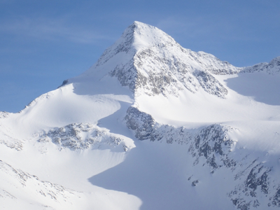
This was our last day of skiing and Grosser Geiger was the obvious target.
Since the route to this peak starts from the lake quite a bit below the hut,
it made sense to return back down the valley rather than to the hut
at the end of this climb.
We left at 0700 and skied down (on very hard morning crust) to the lake where
we made a cache, leaving all our gear that we did not want to take on the summit
climb. Thus, it was almost 0800 when we left the cache and skied up the big
gully that steepens considerably near its top. Reaching the glacier at 0845, we now
had easy skiing that would lead us
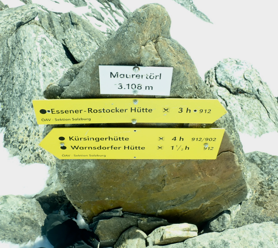
to the key col at 3108 meter called
Maurertörl.
We left the col after a short break around 1100. Traversing high below the
cliffs, we crossed an area where (small) avalanches kept coming from
patches of snow on the rocks higher up. We slowed down due to heat and general
fatigue, perhaps more correct, why hurry on such a beautiful day? Still, it did
not take long before we were at the final snow slope leading up to the
summit of Grosser Geiger. I left my skis and walked up the slope, reaching
the summit around 1250. Somehow, Eric had fallen behind. I enjoyed the good scenery
and the fine summit until 1320. Wondering what Eric was up to, much to my surprise
he now arrived with his full backpack loaded with skis! He clearly put in a
considerable effort walking in the steep, deep snow with such an extra load.
Skiing from the summit, I had to hurry as he would otherwise get way ahead.
The return ski to Maurertörl went quicker than expected, after there a long
ski descent awaited. Still, we had a long way back down to our car near
Neukirchen. Retrieving our cache increased the load in our backpacks and the
day was still hot.