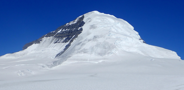
Mount Columbia
- Mount Columbia
- 3741 m
- Primary factor 2361 m
- Alberta, Canada.
- Location: North 52.14768, West 117.44170 (GPS at the summit)
- Difficulty: YDS class 3
- Attempted August 8. 2018
- Climbed May 18. 2019
Mount Columbia
|
|
How to get there:
Drive Hwy. 93 between Lake Louise and Jasper. To be precise,
go a few kilometer (west) on Hwy. 1 from Lake Louise, then fork
right onto Hwy. 93. This is called the Icefields Parkway. Drive more than 100 kilometer.
Locate
the Icefields information center (big building and parking lot) on
your right. Make a left off the highway and drive down to a smaller
parking located close to the end of the glacier that comes
down the valley. This location is at N52.21252, W117.23291, elevation
about 1930 meter.
Route description:
This climb is best on skis in the spring before the snow has melted
too much off the glacier.
However, the best route up the icefall is essentially the same in spring as well
as in late summer.
Access the lower part of the glacier directly from the tourist path/road. The lower
part of the glacier is pretty flat and largely without crevasses, at least they do
not pose any problems. Looking ahead, the glacier has three steps. First, the lower
icefall, very crevassed. Behind and hard to see from below, there is a flat zone
where the ice is compressed, this area is also essentially crevasse free. Next comes
a very rough second ice fall, however this has a somewhat smoother area on the left
side when viewed from below. Finally, there is the upper part that has a large
snow slope coming down the middle.
The best route therefore proceeds up the lower part, then turns the lower ice on its
far right. In this area there are rocks and ice mixed, proceed carefully uphill quite
close to the (steeper) slope coming down far right. Next, turn left and cross the
flat area between the two broken up ice falls. Locate a smoother looking "minor ridge"
that climbs on the left side, but not far left. This area may be more
difficult in summer, but one should normally find a way. Once higher, almost to the
level of the base of the central snow slope, cross over there following long
sections of ice with crevasses on either side. There are several parallel routes
that may work. You should now be back at a flat section in the middle of the
glacier with a snow slope extending uphill.
In spring, this slope connects nicely with the higher part of the glacier. In the summer,
one may need to shift right and continue on a second snow slope that extends higher
up. There are crevasses in this area and also higher up where the glacier breaks from
more gentle to a steeper slope. These crevasses are largely hidden and utmost care is
required to cross higher and finally reach pretty stable snow.
Ski across the main glacier that covers the large platau in order to reach a
very well defined col (almost a small valley) that separates the glacier you are on from the
glacier supporting Columbia.you are on from the
glacier supporting Columbia. One should cross this col near location
N52.13659, W117.35364, elevation about 2675 meter. There are some huge ice caves near where
the slope down to the col steepens, thus care is needed if you have limited visibility.
Ascend on the far side and pick a course heading directly for Mount Columbia. Ascend a broad
snow ridge leading up to the steep part of the mountain.
One should be able to ski at least to near location
N52.14344, W117.43261, elevation about 3230 meter.
From here, ascend uphill, slightly left, then ascend the snow slope having some visible
rocks on your immediate left hand side. The slope is pretty consistent almost to the top.
The average slope between 3400 meter and 3600 meter is about 41 degrees.
When you enter the summit plateau turning right, there is a high point pretty immediately, then another
high point connected (left) by a shallow col, the summit area is overall pretty flat, but one should
be aware of possible cornices near the edge.
Comments:
August 2018:
I did this trip with my son Pål Jørgen and my friend
Åke. We had just picked up Åke at the Calgary airport, then
driven to Canmore where we stayed in a local motel.
Early up and start driving before daylight at 0500.
We arrived at the Icefields around 0730. It had been recommended
to check the conditions on the mountain by calling "Public Safety" in
Jasper. I spoke to a friendly guy named Jonas. He did not think we could
find a safe route up the glacier, but asked to be informed after the
trip about the conditions.
We got going at 0830, a short walk to the lower left end of the glacier.
Roping up, we crossed the small creek on a narrow bridge (single plank),
then headed uphill. The glacier was slightly bumpy, but completely crevasse free
in this area. Shortly, I noticed some engine noise on my left and somewhat
surprised, I observed a bus crawling up the glacier on my left hand side.
First time I have been overtaken by a bus when ascending a glacier!
The bus drove (very slowly) up to an area fenced in by "do not cross" ribbons.
Here the tourists could take pictures and later claim that they had been on a real
glacier.
We walked up to the tourist area, crossed the first line and then the second one.
Clearly, an extra attraction, real climbers walking with a rope and crossing the
barriers that were in place to safeguard agains dangerous crevasses. Higher up,
we ran into bigger challenges. The ice-fsll up front was really quite bad, no
obvious route. We first tried a pretty direct line, but soon ran into more
trouble than we could easily handle. We retreated and tried a line up along the
right hand side. At first, this went well, but after climbing a snow slope we ran into a monster
crevasse that blocked this route. However, from here we had a better view
and could plan a third route. first descend back to the more level area, next cross
all the way to the left side taking advantage of terrain that certainly looked like
a compression zone. From there, perhaps a traverse to the big snow slope going up
the middle that we had spotted already from the trailhead. This plan worked, the
traverse back into the middle ran parallel to lots of crevasses but they all seemed
to run parallel with no bad break across. Making good progress, we soon ascended onto
more permanent snow and nav igated across the upper area with crevasses covered by
a shallow layer of snow.
It was unbelievably warm as we walked across the main glacier and descended into
the trench, a distinct valley/col that separates the Columbia glacier from the big
glacier extending from the mountain Snowdome.
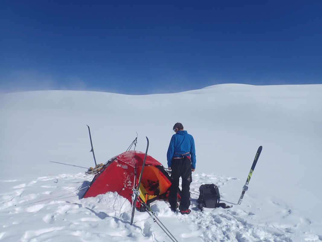
We established camp here, certainly within striking distance of our goal.
The next morning, the same nice and very warm weather. We started out after securing the tent
with an ice screw, the sun was so hot that all tent pegs would melt out in a couple of hours.
It still took a few hours to walk up to the broad ridge that led directly to steeper
terrain. We traversed left and climbed a distinct step (with crevasses) in order to access a
pretty wide and open slope stretching uphill. The unpleasant surprise was that this
surface was plain ice with very little snow. Rather, there were some patches of thin snow,
but these were indeed part of the problem. The crampons would not get through to the ice and
the patch itself seemed to detach from the ice and slide (with man on top). Not good. We ascended
while traversing towards a rock rib further left. Our main trouble was the lack of a larger
supply of ice screws. One had been left by the tent. We stopped at the rock rib and discussed
the situation. We were near 3500 meter, so 250 vertical meter remained. Pål tried to climb up
on the rocks, but this was bad, since virtually all rocks that he touched, would start flying downhill.
I came to the somewhat unfortunate, but likely good conclusion that we should turn around. The conditions
were just not safe when matching up our team and (missing) equipment.
We descended back down rather carefully, then walked back to camp. It had been a full day,
no summit, but a very nice time in a very scenic landscape.
The next day, we broke camp and walked across the main glacier. Before getting to the steeper
snow slope, we crossed a revassed area with mostly hidden crevasses. Many snow bridges that
could be used. Suddenly, Pål stepped into a crevasse that had been completely hidden.
The rope was tight and we immediately pulled him back. Still, a good reminder that it is
essential to use a rope under this conditions. Pål led the way down, we did not find
exactly the same route, but close enough to avoid serious difficulties. We again crossed
the tourist area, then concluded our trip at the very end of the glacier.
Thanks to Pål and Åke for three very nice days in the Icefields.
May 2019:
I certainly noted (in August) that this peak would be very well suited for
a spring ascent using skis. I planned a trip and asked if anybody would like
to come along during a Thursday meet in the local mountaineering club. To my
great delight, Helge pretty immediately said that he would join me.
We bought tickets for a flight on May 1st. However all the SAS airline pilots
went on strike and the trip was postponed 2 weeks. We flew to Calgary on
May 15th. staying at Days Inn Northwest from Wednesday to Thursday. driving
north the weather was misty with rain. We stopped in Lake Louise to
buy fuel for our stove. Last year, we had brought our Primus burners only to
discover that the gas canisters were incompatible - thus we needed to buy
two Canadian burners for our camping needs. This time, I brought one of
these with me in order to buy the local fuel. To our great surprise and
amusement the store had changed to Primus - thus we needed again to buy
a new burner, just identical to the ones we did not bring with us.
We parked at the Icefields parking shortly before 1500, then started skiing.
The terrain was easy and there were no issues with crevasses. We reached the
col near the base of Snow Dome after 5 hours.
A good place to put the tent.
The next morning, we still had white-out conditions with a bit of fresh, new
snow. We decided to do a local trip, hoping that the weather would improve
on Saturday. Thus we skied up to the summit of Snow Dome, then onwards to
the connecting col before ascending Kirchener. Returning, we bypassed the
Snow Dome summit on the left, arriving back in camp after 6 hours - all
in a complete white-out with almost no visibility.
Unfortunately, the same weather persisted on Saturday morning and we decided that
it would indeed be risky to wait another day and do both the climb, the descent and
the travel back to Calgary in a single day. We started out at 0845 with zero
visibility - skiing across the main glacier and across the col to the base of
Columbia. Starting the ascent around 1215, we summited in 3 hours and spent
about 20 minutes on top without seeing much at all.
Descending in about 1:30, we skied back to camp, arriving there nearly 12
hours after leaving. The lack of visibility required careful route finding
which slowed us down. Also, the new snow meant breaking trail all the way - both
ways as the ski tracks were completely gone when returning.
The next morning was sunny and we got a great view of the landscape. Helge certainly
appreciated seeing where he had been the last couple of days! We had a relaxed morning,
cleared and packed camp, then started skiing downhill. The next couple of days promised
good weather and several teams were on their way up the glacier. We had a good trip back down,
the landscape and icefall are certainly very impressive.
After a scenic drive down the Icefields Parkway, we first took a tourist walk at
Lake Louise, followed by a very nice dinner at the Lake Louise Station Restaurant.
I was quite surprised that the hostess immediately recognized me from my visit there
last August. This was a good way to celebrate a very successful trip, many thanks
to Helge for good company!