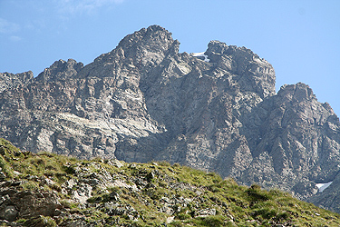
Pizzo Coca
- Pizzo Coca
- 3050 m.
- Primary factor: 1878 m
- Near Bergamo, Northen Italy.
- Location: North 46:04.291, East 010:00.690 (GPS at the summit)
- Difficulty: YDS class 3 - French Alpine: PD-
- Climbed July 21, 2009.
Pizzo Coca
|
|
The summit route leaves the trail exactly at this saddle. Head left (north) and locate an obvious
gully that climbs higher slightly to your left as you face uphill. The route is further marked by
red paint and several cairns. Climb this gully
and continue a bit right where you locate a second
gully, considerably wider. The climbing is easy scramble, quite prototype YDS class 3.
In this area there is a route fork, white painting with an arrow pointing left says "Facile" (easy),
while an arrow pointing more right says "Difficile" (difficult).
The (easy) route is well marked and most of the way easily followed on a climbers trail. A bit higher,
there are again two choices, the
easiest runs up a gully slightly left, while the alternative, perhaps
with the better view, turns a corner and swings around in an arc to hook up with the first alternative
a bit higher up. This variant has a single step that is slightly steeper, but still within a YDS class 3
level.
Next, follows the steepest part of the route, however, on very large, flat steps, more or less like
a steepish staircase. This section is absolutely
straightforward, but with more "air" as you climb
higher. After this, the route regains the main ridge on a shoulder, then continues uphill across
a south face where numerous ledges provide good zig-zag alternatives. Look carefully for the red
markers in order to follow the easiest route, there are several variants that stay within a
YDS class 3 (scrambling) level. Before long, you will see the cross above you and with a few more
steps you arrive at the summit.
Comments:
I did this climb with my son Pål Jørgen, age 20.
We arrived in the small village of Lizzola
on July 20th. and established our
"family BC" there. There were nice trails starting out from this area where Heidi
would make her next day hike.
We drove back down to Valbondione, made a right turn and located a small parking area
near the trailhead without any problems. After a short review of gear, we were on our
way by 1415. The trail was nice and easy, but a very steady uphill on a rather warm day.
We were quite happy to finally cross the creek at elevation 1600 meter, a break for
water had been in high demand for some time as we started out without water in our
bottles.
We arrived at the rifugio by 1615, and found only a few people there. Just as on the Fridolin hut
(on the Tödi climb) everyone were doing hut to hut walks and nobody planned to climb Pizzo Coca.
We asked for a "self serve" breakfast by 0400 and got our private room upstairs. There were several
men at the rifugio doing repair and/or remodelling work while we were there. After a nice dinner
we went to bed early in order to catch sleep before our next day ascent.
We left according to plan at 0515 the next morning. No need for light, it was a very clear and nice morning.
Proceeding uphill along the trail, we soon arrived at the frozen lake, Lago Coca, and noticed that the
trail climbed on the left side. Well, perhaps the trail needed to bypass some steeper cliffs, we expected
to find our trailfork at the opposite end of the lake. However, our trail obviously climbed left and we
scrambled down to the flat area beyond the lake. No trail to be seen. Concluding that we had missed the
trailfork before getting to the lake made us walk back, this time on the opposite side. Eventually, we spotted
a rather marginal trail crossing upwards among many rocks. This detour had certainly been a significant
delay.
Back on the trail, we ascended steeply. In fact, the trail has a short section of easy scrambling in a small
gully in order to gain the better terrain higher up. From here the trail was very clear and easy to follow.
Gaining the ridge, this trail climbs in such a way that you actually can look down back to the Rifugio Coca
almost all the time. We spotted several nice ibex with impressive horns out for early breakfast grass, unfortunately,
the early morning light was not ideal for my camera.
Higher up, we arrived at the emergency communication pole,
a system that could be used to alert of difficulties.
From here, we could see the Bocchetta dei Camoscio col on the
opposite side of a snowfield. We decicded to turn this on the left side since we were still walking in light
jogging shoes only. This choice was wrong as we entered very loose and unstable talus. Much better to go on the
right side as we learned when descending. Arriving in Bocchetta dei Camoscio at
0725, we made a stop in order to prepare for the climbing section of the route. We decided to leave all heavy gear
(crampons and ice axe as well as mountaineering boots), since the rock looked dry and since we had only seen very
isolated patches of snow.
The route was well marked and the first scramble up a gully
was clearly within a (YDS) class 3 category.
Higher up, we turned the corner instead of going directly up a gully. Fun scrambling without any hard sections.
We then arrived at the steepest part of
the climb, beautiful "steps to heaven".
Very easy, but now going up at
an angle that would be uncomfortable for people not used to "airy conditions". Obviously, a fall here would be
dangerous, but the climb was like climbing a steep staircase - very easy.
Higher up, we ran into one small snowfield, but it was easy to bypass on the left side.
The rock was nice and solid, but seemed pretty eroded in places, even to the extent that
we spotted a hole in the rock.
The terrain was mostly dry rock and we were both happy that we finally climbed a peak where crampons,
heavy boots and ice axe were needed. Incredibly, we spotted
small groups of alpine flowers coming
out of cracks that seemed essentally free of any soil to grow in.
The climbing continued
at (easy) YDS class 3 as we entered slope with ledges going across. The easiest route made a wide left turn
that we both missed, but going more directly uphill
did not get us into any difficulties either.
We arrived at the summit by 0825
and felt that we were doing quite fine with respect to time,
including our return to meet with Heidi.
The weather was fine and the view fascinating. We could look back down on the rifugio,
across (still down) to Lizzola and even
directly back down
to the village of Valbondione.
The Bernina group
dominate the view to the north. A pretty big lake,
Lago del Barbellino, 1862m,
created by a dam further
up the valley from Valbondione, did also catch our attention.
A fairly level summit ridge continued out to
the north-west, otherwise we had immediate drops to
all sides.
We had lunch and decided to start back down
after spending a bit more than 30 minutes on the top.
Descending was an equally fun scramble as going up, soon we were back in the main col where we had left
the heavy gear. Descending further, this time taking the correct side of the snow patch, brought us
back to the Rifugio Coca by 1115. We rested and paid our dues, then continued down by 1230.
It took us 1:20 to hike back down to the car, arriving there by 1350.
This completed our family summer trip in 2009. We travelled onwards to Como lake where we have a
favortite hotel in Varenna. After two nights there, we drove to the airport in Milan and returned
back home to Bergen, Norway on July 23rd.