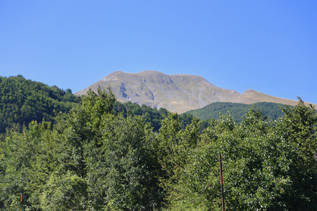
Monte Sirino (Monte Del Papa)
- Monte Sirino (Monte Del Papa)
- 2005 m
- Primary factor 1167 m
- Italy
- Location: North 40.13212, East 015.83166 (GPS at the summit)
- Difficulty: YDS class 2
- Climbed August 1. 2017.

Monte Sirino (Monte Del Papa)
|

|
How to get there:
From the autostrada A3, the easiest route is from the north exit in Lagonegro. From there,
follow Hwy. SP26 east, then turn right onto a smaller road that serves the ski area.
There are signs for the ski area all the way from the A3 exit.
Park near the beginning of a skilift at location N40.14413, E015.83836, elevation about 1560 meter.
Route description:
Follow the ski area service road as it climbs parallel to the ski lift.
This leadsall the way up to the col east of the mountain
at elevation 1870 meter. from here,
just ascend the slope on your right, there
is no clear trail, but the terrain is easy to walk almost everywhere.
Once you have gained almost all the elevation you will notice that there are
three competing humps for the highest point. Furthest
along is a summit with
a cross, closer and somewhat to your right
is a small summit of very
similar height. More to the left is the third hump, this is slightly lower.
It is easy to just visit all three.
Comments:
I started walking at 1005 and arrived at the summit with the cross 50
minutes later. This is the summit that has been defined in the heading above.
The neighbor hump at location N40.13232, E015.83315, seems to be very close
in elevation, while the third hump at location
N40.13117, E015.83313, most likely is slightly lower.
I enjoyed the view, noting that a nearby summit has a road all the way to
a house on its very top.
I visited all three summit contenders, they are
very close so this cannot be considered any detour.
After about 15 minutes, I descended back down in 30 minutes.