Pukeashun Mountain
- Pukeashun Mountain
- 2301 m
- Primary factor 1696 m
- British Columbia, Canada.
- Location: North 51.20480, West 119.23523 (GPS on the summit.)
- Difficulty: YDS class 2
- Climbed August 3. 2018
Pukeashun Mountain
|
|
How to get there:
First, locate the town of Sorrento at the north-west branch of Shuswap lake.
Drive around the west end of this part of the lake to the north side. Follow
the main road there as it leaves the lake and heads inland. Shortly after
crossing a small bridge near location N50.9296, W119.4749, a dirt road named
Scoth Creek Forest Road, forks left. What remains is 48 kilometer mostly on
pretty good dirt road. The road has kilometer mileposts, you should follow
this road to near kilometer 35. Fork right and continue about 10 more
kilometer to Grizzly Lodge. Just before the lodge (you will see the building),
fork left on a somewhat rougher road. Go right at the next fork and drive up
a hill to a distinct hilltop. Park on the side of the road here. This location
is N51.17974, W119.29321, elevation about 1540 meter.
Route description:
Once you are parked (or have walked) to the trailhead
described above, you are already on the correct ridge. The short
version is: Just follow this ridge all the way to the summit.
However, this is perhaps easier said than done. There is no trail and the
first part of this route is 5 star bushwack. You need to get to about 1900 meter
of elevation before the hike gets pleasant. From there on, the ridge is quite
well defined until a small descent. Thereafter, the ridge turns into a pretty
wide plateau. Just follow the highest ridgeline and you will locate the
summit with a cairn.
Comments:
After our climb of Dunn Peak, we stayed in Barriere. The next day forecast
was not good and called for an easy hike. We left Barrier shortly after
0500 and drove the good road directly across to Adams lake, then the (also good)
dirt road to Shuswap lake.
Going up Scoth Creek Forest Road, we made the mistake to try a smaller forest road
that forked right, since it was marked on our map as a possible shortcut.
However, this road is a dead end (the map was in error), loosing perhaps 30 minutes.
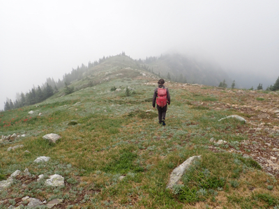
We parked on the hilltop and started hiking at 0905. Quite a fight to get through
the pretty dense vegetation, it was certainly high time when the terrain finally became
nice. We had fog and limited visibility, arriving at the summit at 1205. A nice cairn, the sun
was not far away and we had some intermittent views. Leaving at 1230, hiking downhill is
certainly easier even in the bush, arriving back at our car in two hours at 1430.