Schneeberg
|
This mountain is located south-west of Vienna in Austria. Locate Hwy. 21 running
east-west between freeway A2 and Hwy. 20 further west. The access road runs south from
Hwy. 21 approximately 4 kilometer east of the village Pernitz. Drive south about 14.5
kilometer following signs for Puchberg. Just as you enter Puchberg, turn right into the
main street (follow signs for Bahnhof). From Puchberg one can take the rack railroad to
elevation 1795 meter on Schneeberg.
There are many trailheads, the rest of this description will lead you to the point of
departure that I found.
At the other end of main street, you will cross the rack railroad (drive slowly!), measure
from this crossing. Continue 2.2 kilometer where you turn left and enter Knipflitz at
kilometer 2.4. Subsequently, you enter the small place called
Schneebergdörfl, pass through and keep right at kilometer 4.4. Continue up the small
road and look for parking off the road, I parked at kilometer 5.1 on the right side of the
road. Do not drive all the way to the house at the end of the road. This is the trailhead,
location N47:46.515, E015:51.366, elevation 787 meter.
Route description:
There are obviously many routes on this mountain, the description below
is a roundtrip made by me, arriving from Vienna with no prior information about
Schneeberg.
From the trailhead, continue up the road and straight ahead. (Do not go left).
Follow blue/white markers as the trail leaves the road and heads directly up
the slope in the big, broad gully coming down from above. The trail heads uphill in
zig-zag turns, partly on the left side of the rocky area. Higher up, there is a trail
that crosses this route horizontally.
(Variant: At this point, one may take this trail a short distance left, then follow a scrambling
route uphill. I became aware of this possibility afterwards.)
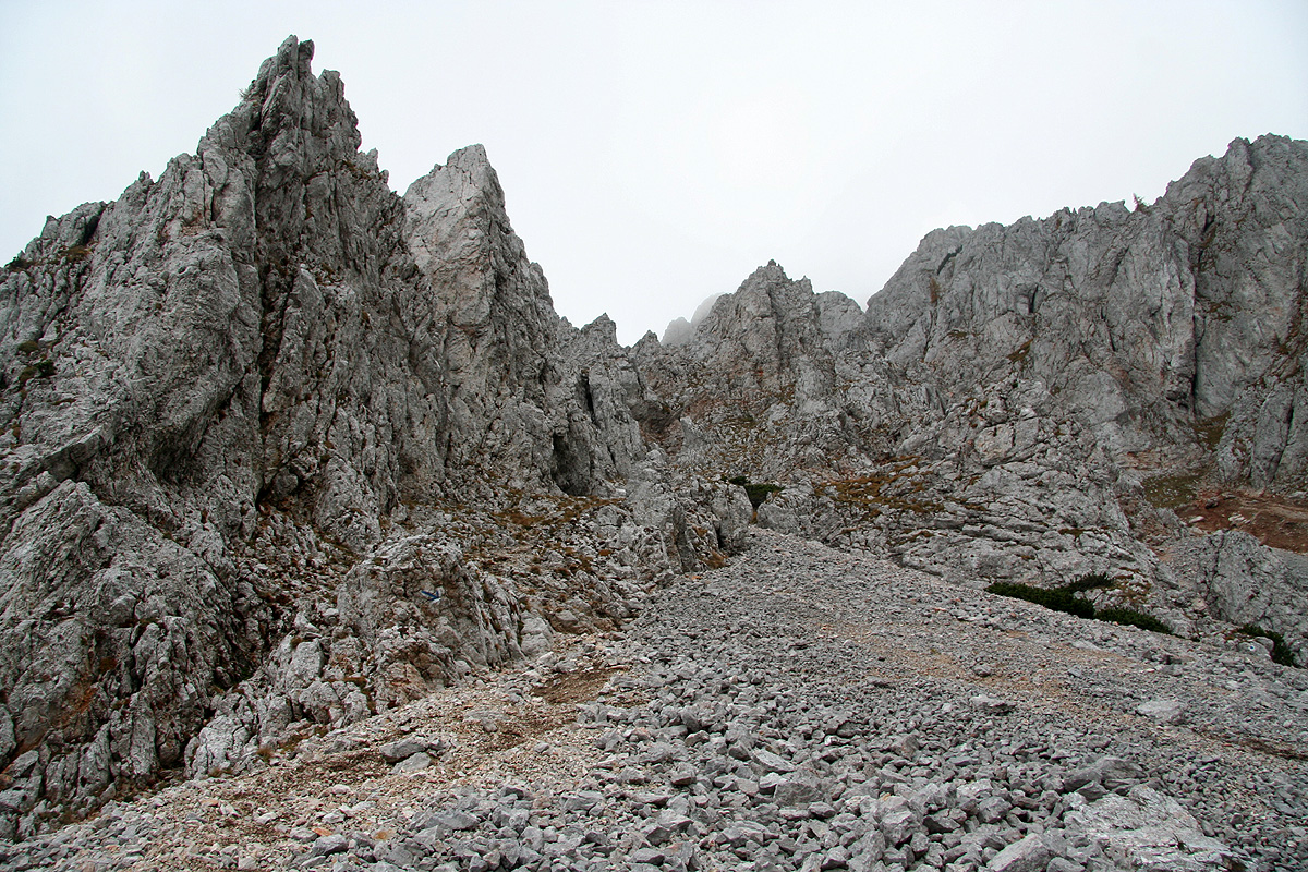
The blue marked trail continues straight
uphill, partly on loose rocks. The path
climbs left of these rocks most of the time, but then crosses right. Be aware of this and
avoid getting too high and off the route. The climb tops out on almost flat terrain with
small pine trees, just below 1800 meter of elevation. Continue straight ahead. You will
soon hit a very broad path and you should see a mountain hut a bit further left. Turn right
on this path and follow it until it forks. Take the left branch, this leads to the
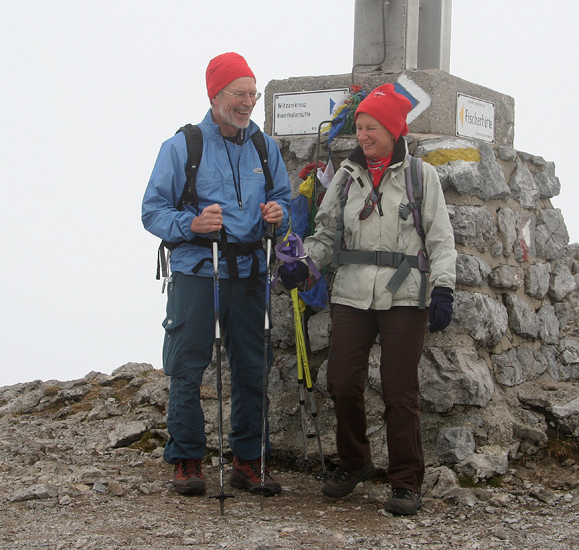
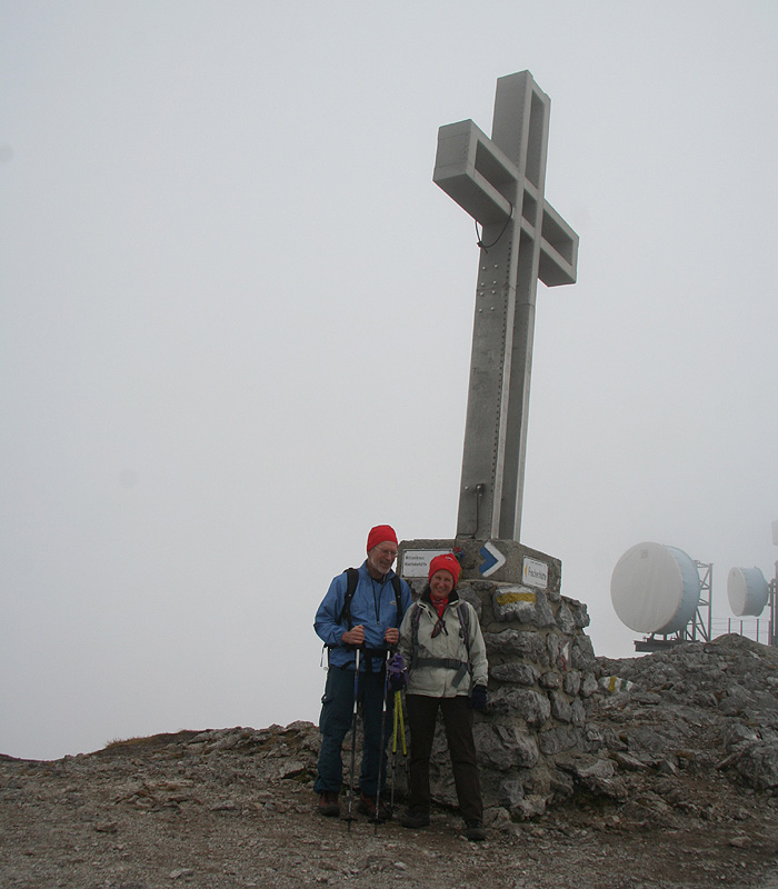
summit of Schneeberg. The summit point is called Klosterwappen. The summit has some antennas
as well as a large summit cross.
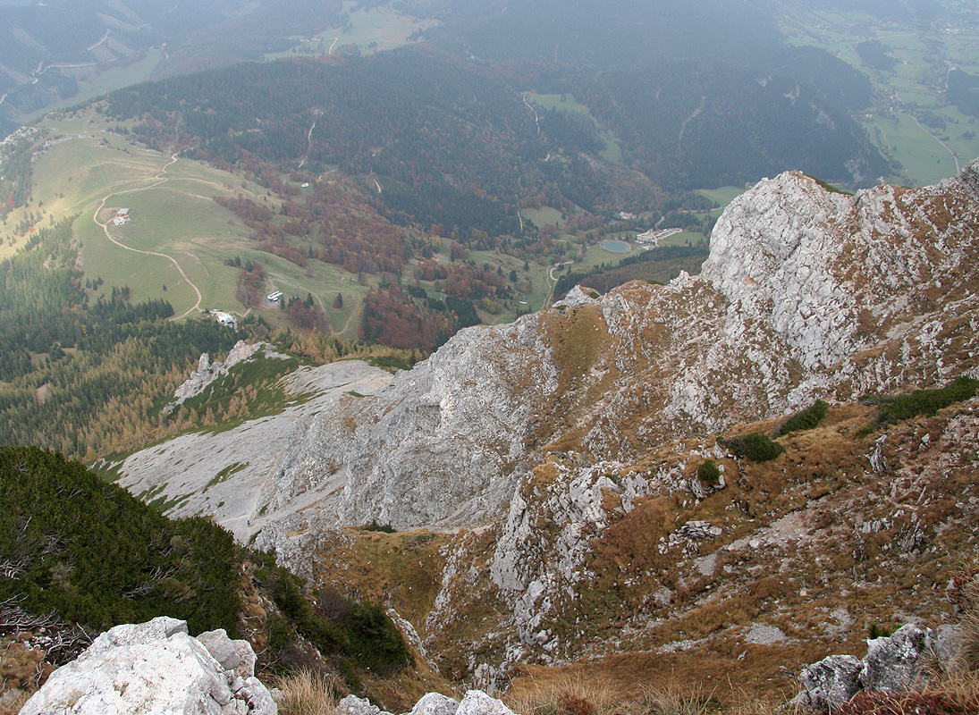
In order to make a loop route, continue along the summit ridge and descend slightly to
another hut, the Fischer hut. When reaching this hut, turn left, then take the rightmost
trail towards the Sparbacher hut. (There is another trail here that immediately starts descending,
the correct route starts out as a traverse and runs further to your right.) After a short
descent, this route emerges on top of a distinct ridge, then descends more steeply off this
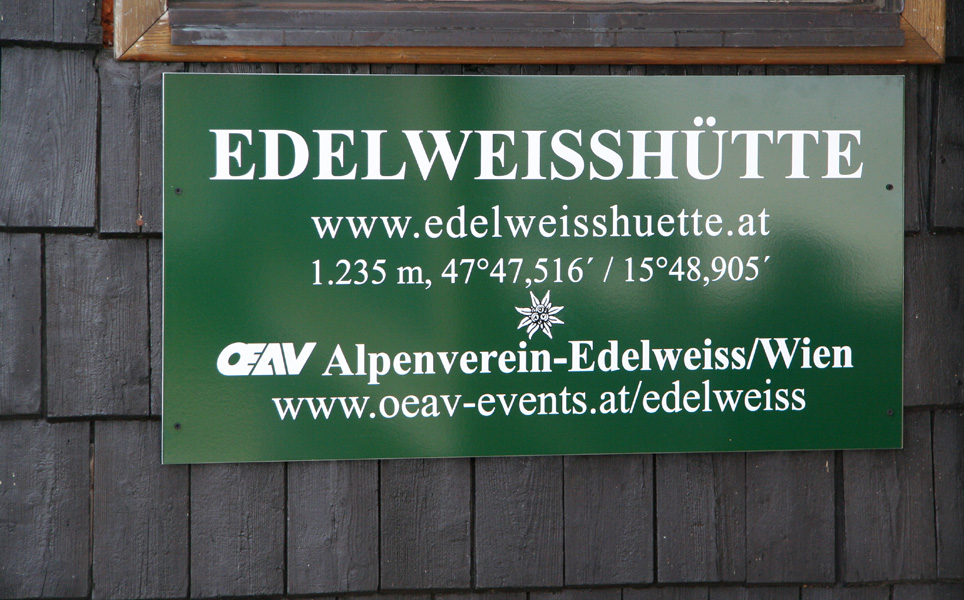
ridge (to your right) in order to reach the Edelweiss hut (N47:47.509, E015:48.905, 1235m)
that is located directly below.
In order to walk back to the trailhead, there are again several possibilities. I descended towards
the top of the skilift just below the Edelweiss hut, then descended a bit further to the right
in order to reach the forest road that one can see below. Follow this road as it traverses
right while descending (ignore the road that heads uphill). Eventually, this road makes a hairpin
curve (left), leave the road here and continue on a slightly smaller road that continues the traverse.
Follow this path (now gently uphill) until it makes a sharp right turn.
At this point, a trail will take you further on
your hillside traverse. Follow this trail (seemingly not much used), until it connects with a new
forest road. Make a left at this forest road and follow it downhill. Whenever you have a choice, take
paths that go right. Eventually, this road will get you back to a point just behind the last farm that
you walked by in the very beginning of this route. A few hundred meter along the road will bring you
back to where you parked.
Trip Report / Comments:
October 7. Summit day in Austria.
I had just said goodbye to my son Pål Jørgen in Vienna after
our very successful and interesting trip to Albania.
He headed back to Norway and school on Monday, while I should drive back to Linz.
Taking a brief look at my Austrian road map,
I decided to visit the closest (to Vienna) mountain
higher than 2000 meter.
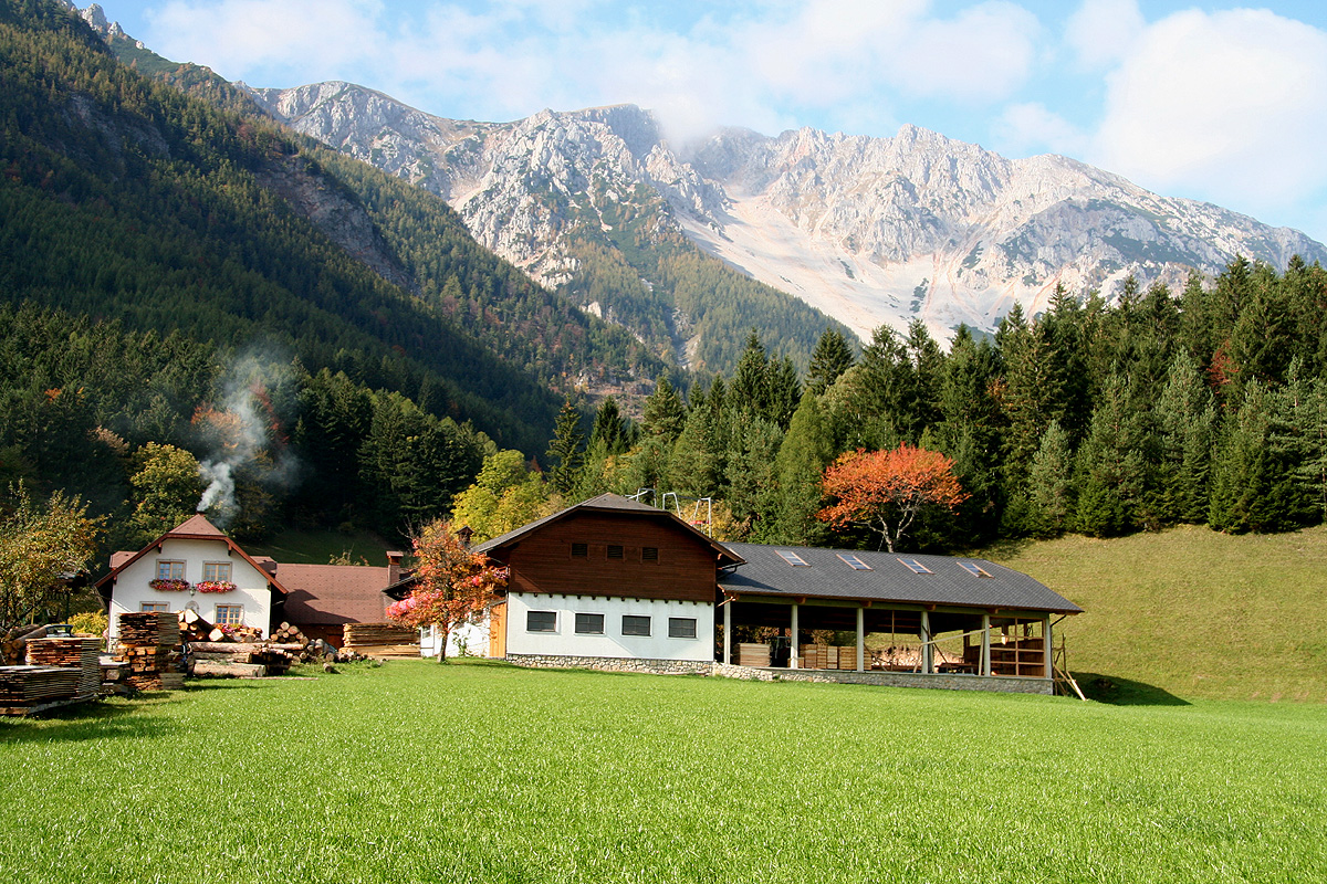
This mountain is called Schneeberg, its highest point called Klosterwappen. This mountain is
the easternmost peak exceeding 2000 meter in the Alps. It is also recognized as the highest
mounten of "Niederösterreich" (Lower Austria). There is a 110 year old rack railroad climbing
high (to 1795 meter) on the mountain from the village of Puchberg.
I parked and got organized, then started out at 1110, just about the same time as Pål's flight
would depart from Vienna. There were a few cars, but I saw nobody, most likely because people
start their Sunday hike a bit earlier. It was pretty obvious where to go and soon I was hiking uphill
on a trail that sometimes suffered from many loose rocks. I caught up with another hiker just as
I arrived at the trail that crosses horizontally. He showed me a trailmap and continued towards
the Edelweiss hut while I continued directly uphill. The terrain looked steeper higher up, however,
the trail was well marked and traversed more right in order to avoid the cliffs I had observed.
I topped out at almost 1800 meter about 2 hours after starting out, what a contrast! The area was
green and flat with small pine trees. Unfortunately, the sun was all gone, I had climbed directly
into a cloud and worried slightly that it could be hard to find the summit, dense fog and I had
no map. These worries were premature as I soon came across a wide path and lots of people. Clearly,
this is a popular mountain and most people do not arrive here by my 1000 meter vertical route, they
rather take the railroad.
I continued along and shortly after branching left onto the summit trail, I caught up
with a couple ahead of me. We exchanged a couple of polite words, then quickly realized
that they were friends/relatives
of Helwig Hauser, recently appointed professor in Bergen, small world.
Thus, we continued together and reached the summit at 1345. There, our ways parted,
it was still foggy and quite cold, so no reason for a long summit stay. I continued
along the summit ridge and descended to the Fischer hut, from there further down
to the Edelweiss hut that I reached around 1500. I decided to have dinner and a good
beer before returning to my car. Leaving after a good meal around 1540, I traversed the
hillside back on a mix of forest roads and a short trail, reaching my car at 1640.
A very nice hike and a good way to finish our Albanian adventure, the drive back to
Linz went smoothly as I arrived in the early evening.