Location: North 47.41133, East 011.43755 (GPS on the summit)
Difficulty: YDS class 3
Climbed: June 29, 2013
Information:
How to get there:
First locate Scharnitz, a small village on the road between Innsbruck and Garmisch, just
north of Seefeld.
The starting point for this climb is the nice mountain hut Karwendelhaus.
There is a (dirt) road from Scharnitz to Karwendelhaus, however, it is closed for
general access. To hike this road both ways adds a significant effort/time, since
it is about 18 kilometer long and gains about 800 meter of elevation.
A popular option is to rent a mountain bike, but this is still a significant effort.
One is now supposed to be able to rent bikes from the camping ground in Scharnitz, ask about
it in the tourist information located in the centre. (This campground was closed at the end of June 2013.)
Another option is to rent a bike in the German village of Mittenwald, located about 6.4 kilometer further north.
Route description: To Karwendelhaus:
The road runs left from the main Hwy. in Sharnitz. Pay attention as you get to a small parking area with
a large information sign on the left hnd side of the road. The road forks here and the correct route is going
left, uphill as you again turn right. The road turns to a gravel road here. From here, just follow the main
road staying in the valley, often just left of the river. The road does climb gently for long stretches. At the end
of the valley, the road climbs in zig-zags in order to reach Karwendelhaus. This nice hut is easily spotted at its
high location far right near the saddle. The distance from Scharnitz is about 18 kilometer and the vertical
gain is about 800 meter. Karwendelhaus is located at about 1765 meter of elevation with coordinates
N47.42734, E011.42184.
In high sesaon, one may be able to rent bikes at the campground in Scharnitz. This place was closed at the very
end of June. A bigger and possibly more reliable place to rent bikes are in Mittenwald. This location is at the
railroad station. Mittenwald is about 6.5 kilometer from Scharnitz. This place opened at 0900 every morning and allows
you to return the bike after hours by locking them outside their building. The cost for an electrical assisted mountain bike
was Euro 35 / day in 2013. Traditional bikes are less expensive.
To Birkkarspitze:
The trail starts about 50 meter from Karwendelhaus and runs directly uphill behind the hut. The first section is
steep as it runs near some avalanche protection. This part of the trail is protected by cables. Next, the trail
contours around the corner and runs horizontally on the left side of the valley. Stay right at the first
trail fork, then left at the next fork which follows very shortly. The trail now ascends a large hillside slope
before it enter the lower part of a huge bowl. From here, at least with winter conditions, the route basically
climbs this bowl, staying a bit left in the lower section, then traversing more right higher up, in order to
finally reach the ridge connecting Birkkarspitze with some subsidiary peaks further west.
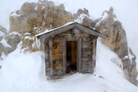
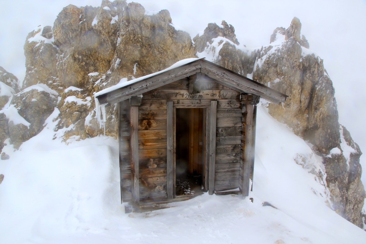
A small emergency shelter
is located behind a rock pillar on this ridge. This shelter is at the very beginning of the final route up
the west ridge.
From just in front of the shelter, the west route starts
up the first few cliffs. There is
a cable here. The remaining part of the route is likely quite easy with summer conditions and there are
more cables protecting passages (view from descent) that
may have exposure. The route basically stays on the right hand side
of the ridge crest. It traverses to and crosses a distinct gully that comes down from the climbers left
side, then reaches easier terrain for the final stretch to the summit cross. Comments:
I did this climb with my son Pål Jørgen.
We arrived from Leogang in the early evening and ended up at the Post hotel
in Mittenwald. The next morning, we learned that the bike rental office did not
open until 0900. Too bad, as we wanted an early start.
Since our primary purpose was to climb Birkkarspitze and since we knew this would
be a big effort with about 700 meter of vertical ascent in snow, the idea of getting to
Karwendelhaus without too much effort was important. I was therefore happy to learn that
the bike rental offered mountain bikes with battery powered electrical assist. (The kind of
idea that I first observed in China.) We rented two such bikes and, finally, by 0930 we were
moving towards Scharnitz and Karwendelhaus. We soon realized that it was a long time since either of
us had done much bicycling. The seat was very hard and we soon felt the pain while sitting.
The electrical assist worked flawlessly and we caught up with several ordinary mountain bikers
along the way. Arriving at Karwendelhaus at 1130, a distance of 25.5 kilometer
with 840 meter of vertical in two hours from Mittenwald - quite good.
The next task was lunch, a big portion of Tyrol soup with meat and a large glass of beer.
We met a young couple that told us they had made it as far as to the bivu-hut (emergency shelter),
located at the base of the final summit ridge. Good news, since this meant some tracks in the
deep snow.
We left at 1215 and soon ran into the snow. We had pretty dense fog and some rain that gradually
changed to wet snow. The snow slope extending uphill, seemed to last forever. The tracks from the two
previous hikers were indeed quite helpful. Only at the upper part of the slope, their tracks had been
filled with drift and also partially been covered by small (surface) avalanches that seemed to
form on this slope. We reached the shelter at 1445, 2.5 hours, mostly in pretty deep snow. By now, the
weather had gotten significantly worse. We had wind and a mix of rain and snow. Add to this that
Pål Jørgen had run completely empty on energy while going up this pretty endless slope
of deep snow. The lunch had not given him enough fuel, we should have carried some extra chocholate bars,
but did not.
Since Pål Jørgen needed a rest, we agreed that he should remain in the shelter while I would
attempt the final, icy summit ridge. I put on crampons and took a couple of slings along, then set out at
1500. There were some route finding problems, the ridge was partially covered in deep snow and many of
the cables that protect this route in summer, were completely hidden. I advanced carefully uphill and got
to a point where a traverse on the right side of the ridge seemed to be the only option. Making a careful
traverse in deep snow with exposure on my right side, it took some time before I reached a big rock near
a gully. I was quite happy to discover part of a cable here, showing that I was on the correct route.
Crossing the gully, then ascending to a shelf, carried me onto easier and safer ground. I could see the
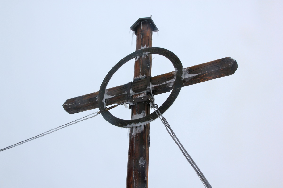
summit cross uphill and the rest of the climb was straightforward.
I arrived at the summit at 1545, the climb
had taken 45 minutes. The weather was still bad, but despite this, I looked around and celebrated my
ascent until 1600, time to descend back to Pål Jørgen. Knowing the route and following my tracks,
the descent took only 15 minutes.
We continued our descent back to Karwendelhaus. It was facinating to see how much of this surface avalanching
that now covered quite a bit of our uphill tracks. Small snowballs roll downhill and pick up (wet) snow along
the way, growing in size to about one meter, then stopping or disintegrating. We were back by 1730, looking forward
to a nice dinner. Dinner was served, unfortunately, we were soaking wet and had no dry clothing to change.
Thus, we decided to take the bikes and return to our car in Mittenwald, Germany.
The rain was pouring as we left
at 1900. It was amazing to see how much downhill we really had. Clearly, the electrical assist had
made bicycling uphill "feel" more as horizontal travel for large parts of the road. Still, this took time,
loose gravel and a lot of water called for caution. We came back to the railroad station in Mittenwald shortly
before 2030, locked the bikes and walked back over to the large parking area reserved for tourists that would
go further on bikes. Finally, changing into dry clothing, w
proceeded to drive to Achensee in order to
set up a short morning hike before heading home from Munich.