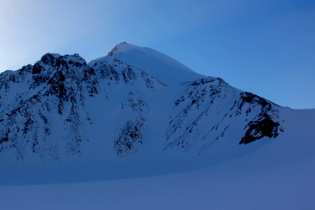
Perriertoppen
- Perriertoppen
- 1712 m
- Primary factor 587 m
- Location: North 79:09.229, East 016:46.754 (GPS on the summit)
- Spitsbergen, Norway
- Climbed April 27, 2013
- Difficulty: (YDS) class 3.

Perriertoppen
|

|
From Trebrepasset, ski north on the huge glacier called Veteranen in order to reach the glacier Gallerbreen.
Turn left here and ski west uphill on the Gallerbreen glacier. Gallerbreen has two cols, the right one is the
one in its north-west corner. From this col, location N79:06.452 E016:55.428, elevation about 1128 meter, there is
a pretty steep, but skiable slope (under normal conditions), that connects with the Trygvebreen glacier about
200 vertical meter below.
One cannot really save much elevation on this route, so the best route is to descend below 850 meter staying
pretty much in center of the glacier. Locate the branch of the glacier that heads north and climbs to the col
directly east of the Perriertoppen summit. Gain this col at location
N79:09.323 E016:49.818, elevation about 1218 meter.
Ascent route:
From the col, head uphill on the broad snow slope, possibly ascending a bit towards the
left side, heading towards, but not all the way to what looks like a ridge line. Gradually,
turn more directly uphill. The slope gets steeper as you get closer to the top. Depending on the
snow conditions, parties may decide to protect the upper part with a rope. We protected the
upper three pitches using a 60 meter rope. Two deadmans (snow anchors) and two ice screws were
used (in different locations) to anchor the rope.
The summit area is pretty large and quite flat, but it is not difficult to locate the highest point.
Trip Report / Comments:
Please see my more extensive trip report.