Jiehkkevarri
- Jiehkkevarri
- 1834 m
- Primary factor 1741 m
- Location: North 69:28.140, East 019:52.716 (GPS on the summit)
- Lyngen in Troms, Norway
- Climbed April 30. 2005.
- Difficulty: YDS class 3.
Jiehkkevarri
|
|
How to get there:
The most convenient way to reach Troms, is by a two hour flight
to the city of Tromsø from Oslo, Norway.
Jiehkkevarri is the highest in Lyngen as well as in all of Troms.
From Tromsø, drive 51 kilometer south along Hwy. E8 (direction
Nordkjosbotn), to Laksvatnbukta. Make a left turn there and continue 17 kilometer
to the small community Lakselvbukt.
From Lakselvbukt, two roads fork south ignore these and continue
approximately 7 kilometers north along Sørfjorden.
You should be in Indre Holmbukta, the road crosses a main river, Storelva on a bridge
at this location. We parked on the left side of the road immediately before this
bridge, location north 69:28.162, east 019:41.806, just a few meter from the fjord.
There is further parking on the right a few hundred meter ahead where a small farm road
forks right. Additionally, there is parking even a bit further near the hill Brentberget.
It takes about one hour to drive from Tromsø to this trailhead.
Lakselvbukt has a small restaurant (on your left after you pass
the church) and a very
ideal place to stay for any party that is headed for Jiehkkevarri.
Contact Birger Elvevoll,
phone (+47)77690433,
I stayed in his nice cabin for two nights, it is only 5-6 kilometer from the trailhead.
His house is red, at the second turnoff (right hand side) after you cross into the 50 kilometer speed zone
in Lakselvbukt.
A more detailed, illustrated Trip Report is also available. This
report provides complementary information mainly via many photos, to the Route description below.
Route description:
From the trailhead, head east, but south of Brentberget, then up along (in winter/spring) on top of
Tverrelva. At elevation approximately 350m, start heading up the very
narrow, distinct valley that comes down on your left, this valley goes off (and up)
to the north-east. The steepest part of this valley is just where some big rocks
can be seen in the spring. Consider possible avalanche hazards, avalanches do happen in
this area both from the left as well as from the right. Higher up, the slope eases and
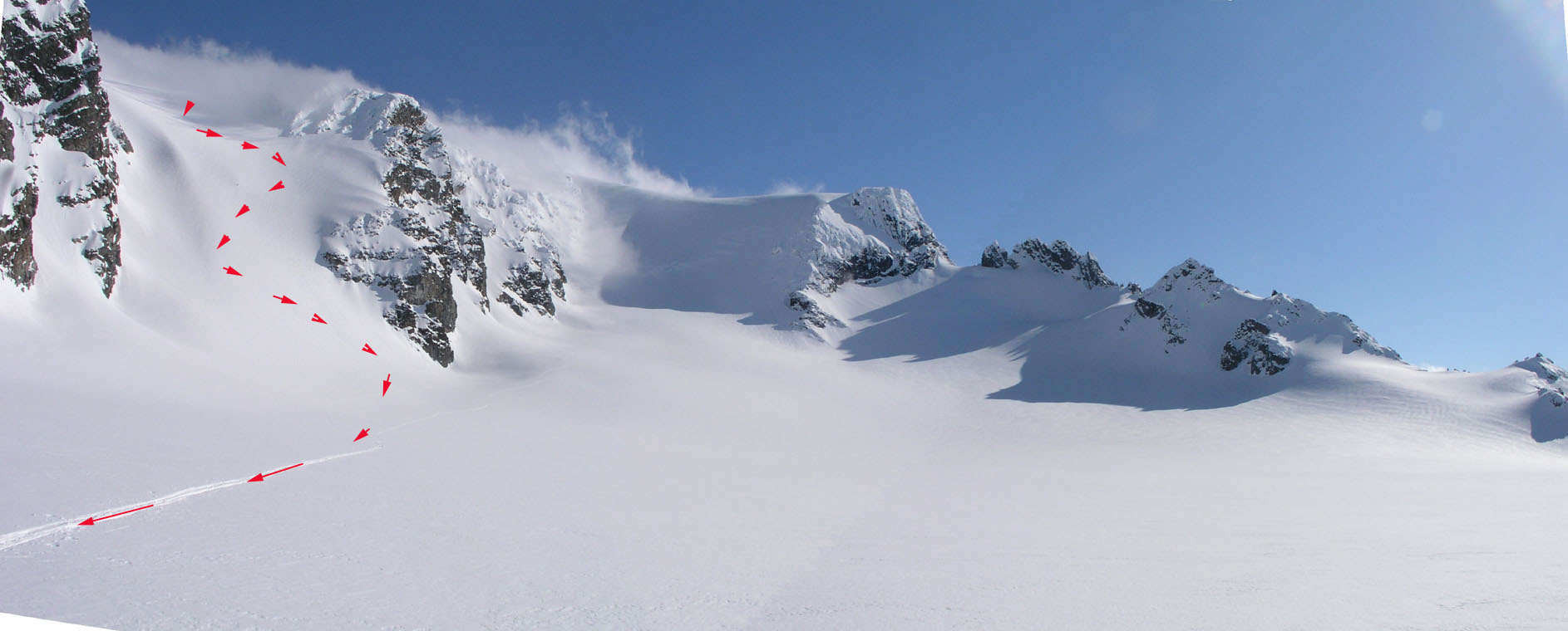
you enter an area where the valley makes a turn to the right. Notice the distinct, lowest point in the
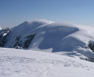
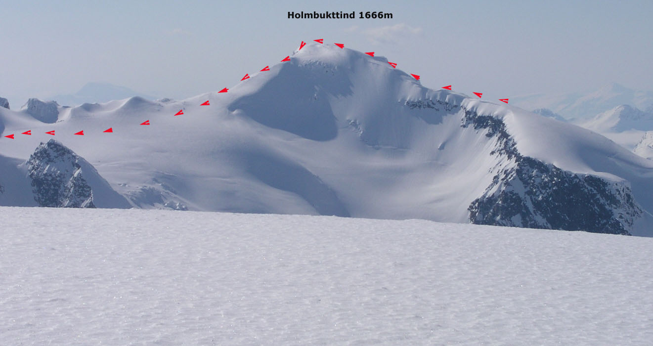
north ridge of Holmbukttind. Continue the climb towards
a point slightly right for this saddle.
The hill gets steeper as you climb and we rested at about elevation 1220 meter where you meet
some cliffs. From here (loc: N69:28.573, E019:47.445), we continued on foot with the skis on the pack, starting
out uphill on the right hand side of the cliffs.
The slope is about 45 degrees in the beginning, less higher up. Altogether, you gain 300 meter in
about 400 horisontal meter.
(Note that variations here may be possible, one can possibly gain the ridge
further north (lower down) by traversing left and then climb to the saddle already described. However, we never
checked this out.)
On the ridge (loc: N69:28.567, E019:48.028), continue to ski uphill directly south to the summit
of Holmbukttind, 1666 meter. Note that
this peak is not
named on the M711 map. From the very summit, locate a ridge that heads down slightly south of east.
First, by a short descent to a somewhat lower summit shoulder, then down the ridge.
This ridge starts out quite narrow, ski with care, soon is broadens and
allows for nice and easy skiing down to about 1500 meter on the glacier that is located 2 kilometer west of
the Jiehkkevarri summit. The route crosses from M711 map 1533-I, Lavangsdalen to map 1633-IV, Storfjord at
this point. This glacier is steeper as it climbs east, ascend it by first gaining elevation going east,
then turn and continue to climb south gaining the flat shoulder about 600 meter west of point 1738.
This ascent is about 80 vertical meter as you enter more
gentle terrain around the 1600 meter contour level.
The hard work is now done, continue east while skiing south of point 1738, then contour into the saddle
east of this point and head along the broad, gentle ridge to the north-east the last kilometer to the
summit of Jiehkkevarri.
One may return the same way, however a much nicer alternative which really consitutes a traverse of
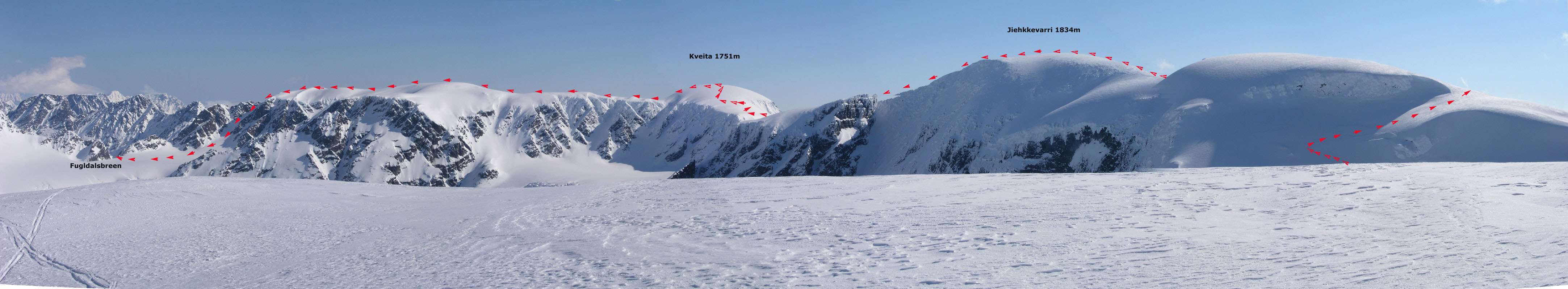
the Jiehkkevarri mountain, is to continue to the white dome Kveita, 1751m,
located about 3 kilometer to the north-east of the Jiehkkevarri summit. Enjoy the nice skiing as you
descend about 400 vertical meter towards the
Jiehkkevarri-Kveita saddle. Pay attention to the terrain as you
approach this saddle, there are some cliffs above the saddle, circumvent these by skiing right (east), then
complete the descent on a descending traverse into the saddle heading north. Be aware that the glacier drops
steeply on your right side in this final section.
The slope up to Kveita appears steep when viewed straight on, however, it is quite reasonable to ski.
Make a few switchbacks as you climb this hill, the slope is a bit more gentle higher up. Take time to enjoy
this third summit of the day, from here on the route is mainly downhill.
The next few kilometers offer very
scenic skiing along the ridge that heads slightly west of north. The marked (elevation) points 1652 and 1666 are
along this ridge. Make sure you do not descend the steep glacier north of Kveita. Ski slightly west of point 1652
and continue to a point slightly west of point 1666. This section of the route has cornices off to your right, there is
no need to ski anywhere close to this side.
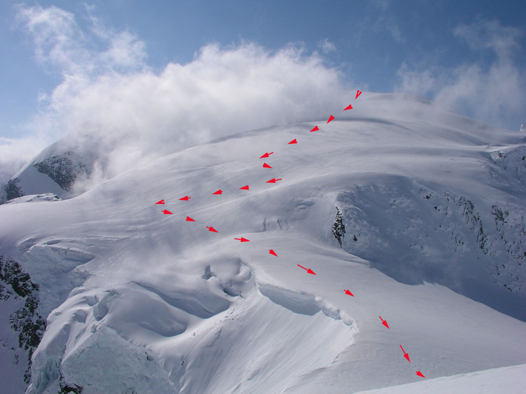
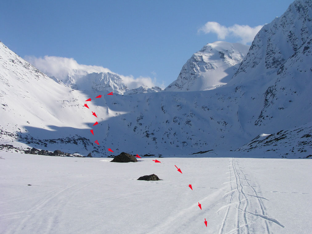
From near point 1666, the next objective is to descend down to Fugldalsbreen 400 vertical meter below.
There are two possible routes, both are steep glaciers. To make things slightly more involved, this is
where we again cross from M711 map 1633-IV, Storfjord to map 1634-III, Lyngen. I had no information about
which glacier to prefer, so we descended the one that starts out west of point 1666. The best route
here is to first descend a bit directly north-west of point 1666, then traverse downward and into the
glacier itself (going west). This traverse is above some steeper rocks, but gets you onto the glacier
in a distinct valley shaped area. The slope is steepest at the top, then gradually becomes more gentle
as you descend down to
Fugldalsbreen. The bottom of this slope is at
elevation 1268 meter, location north 69:30.126, east 019:53.873.
(Note:
It may be quite possible that the alternative
glacier furher east is at least as good if not
a better alternative. Viewed from below,
this glacier appears to be steepest near its middle section
with more gentle slopes below and above. To reach it, continue a descent north from point 1666 until
you reach the 1600 meter level, then continue descending towards north-west. The slope is easy down
to 1500 meter, then gradually steeper to about 1300 meter before a more gentle finishing section the
last 100 vertical meter.
I have learned after returning from this trip that this alternative
glacier is, in fact, the "recommended" route.
The steep slope here is sometimes nicknamed "the skijump hill". )
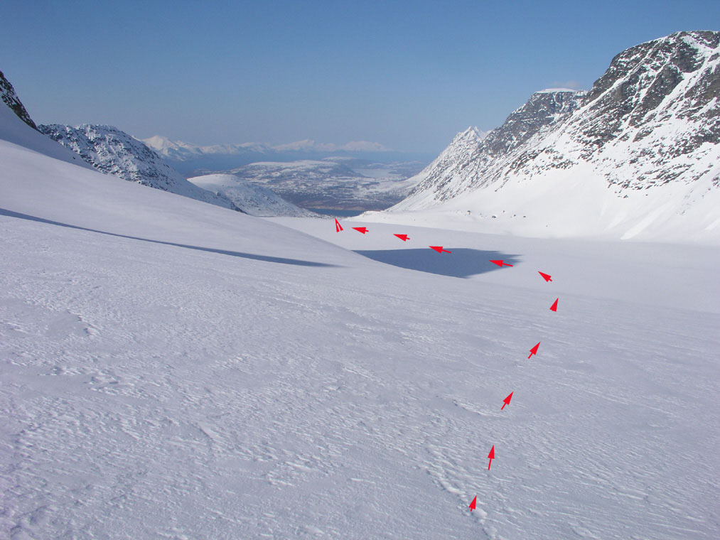
Fugldalsbreen is a nice place to be, enjoy it before proceeding to the distinct pass, Fugledalsskardet on
the north-west side. When we skied here, a big cornice had formed just before the pass. One could
ski a steep traverse near the pass or just downclimb this steep snow before gaining the last few vertical
meter to the pass itself.
The next 3 kilometer descends the Fornesbreen glacier,
first very gently then virtually flat heading north.
At the end of this glacier, the terrain drops more steeply another 300 vertical meter to
Fornesbotn,
the inner part of the Fornesdalen valley.
However, this slope is not difficult and can be skied almost anywhere.
What remains is now 4 kilometer with pretty flat valley, then a final kilometer down to Furumo, the last house
on the road from Lakselvbukt.
Unless you have made advance plans (recommended), the last challenge is to secure transport
back to the trailhead below Holmbukttind. The distance is about 20 kilometer and after such a very
nice Jiehkkevarri traverse nobody deserves to walk back along the road. Hopefully, you will locate somebody
from whom you can purchase return transport.
Note: This route can clearly also be done in the reverse direction, however, I do think the best route
is as described in this report.
This route is not very difficult, but involves extended glacier crossings, steep terrain and
mountains where alternative routes are limited.
Any party should be familiar with glacier travel and be equipped to safely travel in an area where there
could be dangerous crevasses.
One should reserve this trip for a day with stable weather.
Additional Information:
After my return and the posting of this report, I received very useful
information from Harald Bohne. He has climbed Jiehkkevarri 41 times ! (this may be a record.)
Instead of going left up across Holmbukttind, one may continue straight ahead up
the main valley and then continue up the glacier called Blåisen (Blue Ice).
This glacier is known for serious crevasses in the upper steep part between 1200 and
1500 meter of elevation. This is a quicker route than the route traversing Holmbukttind.
Yet another approach is to climb the South-West glacier just opposite from the
impressive Lakselvtindene. In this case, you need to head in the valley Andersdalen (along
the Storelva river), then ascend up into the bowl below the glacier. This route also
requires a roped team up the glacier. Harald thinks this is the most spectacular route.
On the route down to the saddle connecting Jiehkkevarri with Kveita, there is a very nice
viewpoint called Balkongen (The Balcony), this is before (south) of the saddle at elevation
1460 meter above the steep east wall of Jiehkkevarri at this location. This is more or less straight
south of the connecting saddle. A great place to make a break and have lunch while enjoying a
fantastic scenery.
Harald further confirms that one should take the second glacier, that is the one further
north-east, in order to connect down to the Fugldalsbreen glacier (we took the "wrong" one).
An alternative exit from here, instead of skiing north to Fornes, is to make a big U-turn on the
Fugldalsbreen glacier and follow it down. One should then follow the right hand side (west side)
and cross the side moraine (move west) before the very lowest part of the glacier. This exit route
will take you by the lake Fugldalvatnet (357m) and back to the road at Ytre Holmbukt. You are then
within walking distance of your point of departure (your parked car).
Finally, if you complete the traverse all the way to Fornes (as we did), but need transportation
back to your starting point, one can call Mr. Stakkenes (taxi-service)
on phone number 77690222 or 91885582.
Tell the size of your party and he will pick you up with a taxi, a van or a bus.
Comments:
This was the first peak on my T5-trip (Toppturer i Troms 2005).
Here is a complete summary of
all peaks climbed on this trip.
I did this climb with my friend Torstein Skage. We started from the fjord at 0720, arrived
at the summit after 5 hours at 1320. My GPS showed 1841 meter, 7 meter too high. However,
being a glacier top the snow depth clearly varies, it is not unlikely that the
summit may have 5 meter of snow in late April. We spent 30 minutes at the summit, then decided to do
"Le Grand Traverse" by a continued
traverse across to the peak Kveita, then along the ridge north and steeply
down to Fugldalsbreen, through the pass Fugledalsskardet and down Fornesbreen and
the Fornesdalen valley, ending at the fjord on the far
north side of the mountain. Including several nice breaks in the exceptionally nice weather, we completed
this traverse of Jiehkkevarri at 1720, exactly 10 hours after the start. We ended the trip at the last house along
the road and fortunately, a car with a ski rack parked outside. I knocked on the door and asked if the owner would
be able to drive us back to our point of departure, a distance of approximately 20 kilometer. Obviously, we wanted to
pay for such service, and he accepted half of what I offered for the help. Shortly, we were back were we started,
a very memorable and successful trip had come to an end.
I arrived in Lakselvbukt late Friday and was caught by surprise that there was no place (like a gas station) to
buy breakfast/lunch for the following day. However, when having dinner at the small local restaurant, I asked about
this and the friendly, helpful locals immediately came to my rescue. The lady arranged for me to pick up
a fresh bread at her nearby house, while another guest offered me a kilogram of fresh shrimp from his catch of today.
Thus, after spending some time Friday night peeling the shrimp, I carried a half bread and a half kilo of fresh shrimps
to the Jiehkkevarri summit. Quite unusual mountain food, but very tasty and a hearty welcome to the Artic (friendly) folks and
(spectacular) peaks of Troms.
This was the first climb in my T5-trip (ToppTurer i Troms 2005).
This was a planned trip to climb high prominence peaks in Troms, Norway in the fourteen days from
April 30th. to May 13th. 2005. An ambitious goal of 10 peaks had been set, however, this
would depend on near perfect weather conditions.
T5 could not possibly have started any better, a great classic traverse in impressive formations with perfect weather!
T5 continued the next day with Rasmustind.