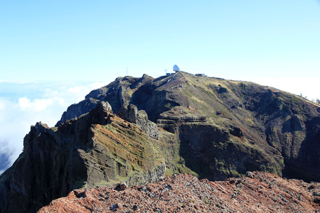
Pico Arieiro
- Pico Arieiro
- 1818 m
- Primary factor 275 m
- Location: North 32:44.140, West 016:55.723 (GPS at the summit)
- Madeira, Portugal
- Difficulty: YDS class 1
- Climbed: December 11, 2011.

Pico Arieiro
|
 |
Summary information about all hikes and climbs in Madeira.
How to get there:
The starting point is the main road in Funchal running parallel to the
waterfront promenade. Locate the plaza where two rivers merge and the traffic
can turn in a somewhat rectangular traffic "circle". Head uphill on the right hand
side (east) of the west river (ie. the river that is most left when viewed from
the sea side.) In just a little less than 1 kilometer from the start, locate an
orange Galp gas station on your left. Turn right exactly as you have this
gas station on your left side. Continue driving this road uphill. Whenever there
is some fork, just continue on the (main) road that heads uphill. You will eventually
get to a small place called Monte. After 8.7 kilometer, keep left (uphill), at kilometer
14.6, you are at Poiso, 1412 meter, turn left here and continue to kilometer 21.0.
Keep left (uphill) and park on your left side. This is the trailhead at Arieiro, elevation
about 1800 meter and the highest road on Madeira.
Route description:
Exit your car and walk directly to the summit marker, located slightly higher than,
and on the left side of the radar dome.
There is a world famous and very
interesting trail from here to the summit
of the highest peak in Madeira, Pico Ruivo.
Read the full description of this trip under the entry
for the peak Cidrao.
Comments:
This hike is completely trivial. I visited here after hiking Pico Ruivo
earlier in the day.