Location N38:08.404, E020:39.464 (GPS at the summit)
Kefalonia island HP, Greece
Climbed December 2, 2006.
Difficulty: YDS class 1
Information:
How to get there:
Kefalonia is the largest Ionian island on the west coast of Greece.
There is a daily flight from Athens to the local airport located just south
of the largest city, Argostoli.
From Argostoli, take a taxi (or drive if you rent a car) around the local bay, then
east along the Hwy. that connects to the village of Sami on the east side of the
island. Follow this road for approximately 11.8 kilometer until it reaches the main
crest of the mountain. Do not descend, but take a right (there may be a sign for Mount Enos)
and continue along a paved road for about 6.7 kilometer. At this point, a fairly wide dirt
road forks left while the paved road turns right. Stop here, this is the trailhead.
There is a small sign saying that you cannot continue on the paved road, it serves some
radar installations nearby. This trailhead is located at N38:10.059, E020:37.109, elevation
976 meter.
We stayed in hotel Mirabel in Argostoli,
it is one of the relatively few hotels that are
open year round. The taxi from our hotel to the trailhead was 30 Euro (2006), a very
convenient way to start the hike. Route description:
The dirtroad that starts out at the trailhead can be followed all the way to
the summit. One may actually drive all the way, but then you only "visit" the
summit. In order to qualify as a European Ultra climb, one must walk from
the trailhead described above, or from the south side starting from the village of Arginia. Comments:
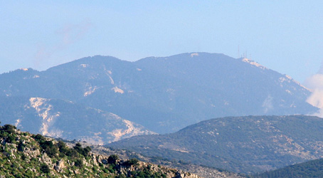
Mount Enos is located in a small national park (established in 1962),
due to the very special fir tree forest
growing near its top. The dark green color of these trees earned Mount Enos its Venetian
name Monte Nero, meaning black mountain. The black Kefalonia fir tree, Abies Cephallonica,
is endemic to Mount Enos, and it is found nowhere else in such profusion and purity,
unaffected by hybrids.
I did this climb with my wife Heidi, very nice company
to an easy, but nice
European ultra prominent mountain. We started out at 0920 and walked at a
good pace in order to reach the summit after 1.5 hours at 1050.
We had a short rest, took some pictures and generally looked around the various
antennas. The summit area
is a bit cluttered by too many antennas.
However, as we proceeded in order to traverse the mountain, shortly after leaving
the antennas behind, leave the road and climb the obvious rocky ridge on your
right hand side. This route will get you onto a short and nice summit ridge that
is almost as high as the antennas. The high point here is located at
N38:08.189, E020:40.049, and measured 1619 meter. We were there at 1125.
Heidi started to descend the short distance back down to the road while I took
some pictures and waypoints. However, when I descended, she was nowhere to be
seen and did not answer my shouting. Hmm, I assumed she had started down the
road, but as I did not catch up with her, I started to wonder if she still somehow
was back up near the ridge. Hard to say, I decided to hike down to the first
road fork, under the assumption that she would definitely not hike any further than that
before waiting. She was not there and after leaving a sign that I had headed back
uphill, I set out going back. Fortunately, I met her after about 2 kilometer. It turned
out that she must have started looking for me, making a loop back up to the ridge as I
descended and we missed each other. An example of how easily one may get separated even
in a somewhat trivial area.
We took the right fork back down where I had turned,
then continued down passing the
Kastelaki monastry on our right before getting down to the small village of Arginia.
This tiny village is well known for a temple of Our Lady, where every year, from
August 6th. until the evening of of August 15th. there appears small (harmless) snakes
called Our Lady's Serpents. (August 15th. is the feast of Our Lady's Assumption.)
From Arginia, we continued on a paved road as it zig-zag'ed down to the village
of Atsoupades. We arrived at the local gas station at 1540, a total of 6 hours
and 20 minutes, a walk of about 26 kilometer. This gas station is located at
N38:05.262, E020:42.298, elevation 190 meter.
From here, we called a taxi in
Argostoli. As it turned out, our driver was the son of the man that had taken
us to the trailhead in the morning. The fare back was also 30 Euro and a very
nice December hike had been concluded.
We tried our "step counters" on this trip (courtesy Intel at Supercomputer 06),
mine showed a total of about 37000 steps, while Heidi's showed close to 39000, fairly consistent
with my stride being a bit longer than hers.