Location: North 59:20.859, East 008:25.103 (GPS at the summit)
Telemark, Norway
Difficulty: YDS class 1
Climbed: October 3, 2009
Information:
How to get there:
This mountain is located in Telemark. The main Hwy. running between Drammen and
Haugesund is E-134.
Locate the intersection at Brunkeberg where Hwy. 41 forks south to Kristiansand.
Drive south approximately 18 kilometer on Hwy. 41 to the small village of
Vrådal where Hwy. forks right (west). Measure from this intersection.
At kilometer 3.9, exit right up a small dirt road and continue to the next
road fork at kilometer 4.2. Park off the road on the right hand side.
This is the trailhead, location N59:20.073, E008:23.088, elevation 310 meter.
There is an alternate trailhead just 100 meter before you get to the
Vrådal church. This is only 2.7 kilometer along Hwy. 38 from the intersection
in Vrådal. Park at the church and hike about 100 meter back along the
main highway. You will then find a small road and a sign saying Roholtfjellet.
Route description:
From the (primary) trailhead described above, hike along the forest road that forks
right. There is a gate (and sign) closing this road to general traffic after only
50 meter (visible from the trailhead). Follow this forest road as it climbs the hillside
making several curves. At approxiately 580 meter of elevation, the road makes a left curve
and another road forks right, there is a wooden sign at this intersection. The alternate
trail coming from the Vrådal church trailhead joins our route here. Continue up the
road (ie. stay left in this road fork), about 200 meter where another sign says that
the Roholtfjellet trail goes right. This location is at 600 meter with coordinates
N59:20.496, E008:23.448. Follow this sign, that is leave the big forest road and continue
right on a much smaller road that soon turns into a trail. This trail is marked with
small, red triangles hanging from branches. It gains a small meadow, then climbs into the
saddle between Høydalskulten (792m, west) and Roholtfjellet (east). The trail continues
north and gains a pretty distinct ridge extending west from Roholtfjellet. From here, the trail
runs eastward as it climbs more steeply until about 900 meter, then more gently along the
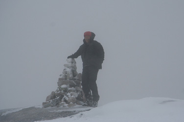
rock ridge onwards to the summit marker and the cairn a few meter beyond at the end of the
ridge.
Comments:
I did this hike with my son Tor Erling. We had driven from Bergen after
lunch on Friday and stayed at the hotel in Morgedal. After breakfast, we drove
to the trailhead. It had snowed during the night and my new studded tyres where
absolutely needed.
We left the car at 0925 and hiked up the road, then the trail. However, up in the
area between Høydalskulten and Roholtfjellet we lost the trail, being misled
by one marker than hung a bit off to our right. We continued pretty much straight
uphill and found the trail again at approximately 900 meter elevation. From here,
we had about 10 centimeter of new snow as we followed the rocky and somewhat slippery
ridge to the summit, arriving at 1120.
It was windy and the visibility was limited, we turned around at 1130 and headed back
down, this time following the trail more closely. We were back at the car, somewhat
soaking wet, by 1300.
We drove back down to Kviteseid and had lunch as well as gas for the car, before
we continued to Seljord. Checking in at the old Seljord hotel, we spent the rest
of the afternoon drying clothes
for a morning climb on Sunday before heading
north to my cabin in Lillehammer.