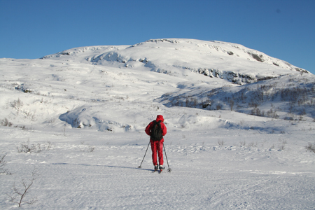
Hamlagrøhornet
- Hamlagrøhornet
- 1080 m
- Primary factor 210 m
- Location: North 60:33.637, East 006:06.019 (GPS on the summit)
- Location: Hordaland, Norway
- Climbed February 11, 2007 and October 9, 2011.

Hamlagrøhornet
|
 |
Trip on October 9. 2011:
I had given a talk on mountaineering for the group of volunter guides of the Bergen Turlag
after a nice hike to Storliknausen, on October 8th. Today, it was
rather windy with rain. I decided to hike Hamlagrøhornet before returning to Bergen.
Actually, I did not remember that we skied it on the way home almost 5 years ago.
I set out at 0830 and made good progress up a wet and muddy T-marked trail. Arriving at the
Kvanngjelet col, I decided to take a waypoint in order to safeguard my return hike. It was windy and
snowing, additionally pretty dense fog/clouds made my visibility very poor. Horror! My goretex jacket
had developed a hole in the chest pocket and my GPS had obviously fallen out. Now what to do?
I decided to continue to the summit, the wind from the south seemed quite steady and I figured that
it would be enough to facilitate my navigation. I climbed rather steeply, bypassing some cliffs, then
into denser fog. It turned out that every little high point seemed to have a cairn. I hiked by several
before finally hitting what I believe must be the summit around 0945. Complete white-out. I turned around and tried to
backtrack by following my footprints in the snow. They soon vanished and I continued with the wind
hitting the left side of my face. A bit interesting without compass and without GPS in pretty nasty
conditions. I believed that I was going slightly more left (south) than on my climb, this turned out to
be accurate. I discovered the steep west facing cliffs and had to follow the top going north until
I intersected my footsteps.
How likely to find my GPS on this return hike? I made a guess that I had about a 10 percent chance
to see it again. Fortunately, about half way between the Kvanngjelet col and the Alexander Grieg tourist hut,
I spotted the GPS quite close to the trail in a muddy section. I was back at the Alexander Grieg hut by 1045,
told the people farewell and subsequently hit the road back to Bergen.