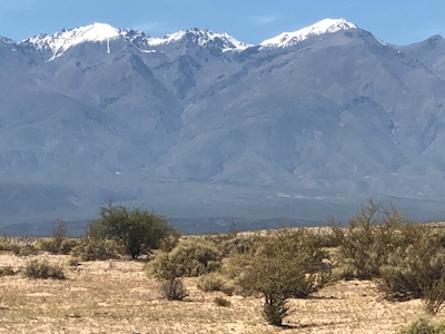
Cerro Bolson
- Cerro Bolson
- 5550 m
- Primary factor 3250 m
- Location: South 27.21350, West 066.09390 (GPS on the summit)
- Difficulty: YDS class 2.
- Climbed February 23 2022.
|
|
Copyright Petter Bjørstad, 2009-2022.
Information:
How to get there:
A good place to start is the city of Tucuman. There are many flights
to here from Buenos Aires.
From Tucuman, travel to the nice town of Tafi de Valle, continue up the valley
and across the pass (about 3050 meter), then descend on the west side,
When you are down in the main valley, go south through Santa Maria.
Continue south to location XX.YY where a smaller dirt road forks left.
Take this to location S27.08886, W66.15313, elevation about 2640 meter.
This is a small farm that serves as the trailhead for
trips organized by Franco.
Route description:
Note:
It may be a smart move to hire Franco as a guide/organizer for this climb.
He can provide mules and make the trip stand out as more "luxurious", where
you only carry a light daypack. It is certainly an expensive option, but
once in a while - why not?
Start up along the rough road and connect to the large river bed, normally having only a very
easy to cross creek. Hiking in this river bed is quite easy, however lenghty. You see the hills
up front, but it seems a long way with ever new bends and creek crossings. Finally, at a fork,
the route picks a somewhat smaller river going more right. After exiting this, the route crosses
more land with characteristic sand-dunes in order to access the correct, large ridge coming down
on the right hand side (as seen from below) of a major valley. Here, the route crosses another
small river/creek immediately before starting the ascent.
This ascent progresses in a couple of steps up the broad ridge. Nearing the top, you pass
some stone structure most likely part of the activity with cows that are present on these slopes.
The trail/route now heads more left, ascending but also crossing numerous gullys.
A possible, but not so nice camp site is located among some more stone (ruin) structures.
The first camp is located on a flat, grassy area with running water nearby, quite an ideal
place to camp. This location is S27.17286, W66.10919, elevation 3950 meter.
The route continues up the hillside just behind/above the camp, one can traverse quite bit
right in the beginning, the aim is to cross over the top of the ridge higher up where the
(ridge) slope becomes more gentle.
A short traverse follows, in order to cross a smaller gully. On the way there, the route
turns a small, rocky outcrop with some exposure. This is the crux point for the mules.
One by one, they carefully are led around this point. The ascent on the other side is pretty
steepish for mules, but before long another corner (easier for mules). Next, follows a nice
traverse, mostly keeping the elevation, into the bottom (creek) of the valley. This valley is
subsequently followed all the way up to camp II. It may be easier to ascend a bit left of the
valley in the upper part of this route. Camp II is located on another flat and nice plateau
a bit left (when viewing uphill) of the creek area. This location is
S27.19511, W66.09245, elevation near 4700 meter.
The summit day, starting from Camp II, first heads right in order to get around the huge
moraine like pile of rocks just above camp. Proceed up the small valley on the upper side and
continue until you are at the lower end of a fairly steepish talus slope. This must be ascended
with some care, many rocks are a bit unstable and may move. This part is therefore somewhat
tedious and it does take a while (looks like a long way). Finally, on top, the terrain is
more level, now above 5000 meter. Continue in the wide valley in front, then begin a
gradual ascent to your right after turning the first bend of the initial valley.
Ascend gentle (snow) slopes, higher up the ridge becomes slightly steeper and considerably
more narrow, but still at least 10-15 meter across. Above this ridge, the terrain again
is much wider, a final big slope to ascend, leading nicely to the more compact and well
defined summit ridge. There is a metal box with a summit register at the far end of the
short summit ridge.
Comments:
Here is a quick overview of the peaks climbed on this trip in Argentina.
We left Tafi de Valle after an early breakfast. We said goodbye to Håkon and wished him
all well hoping that his health problems would now quickly improve. It was very unfortunate
that he could not participate, this trip sort of started with me asking him if he
would come along and climb Cerro Bolson.
After a nice drive we arrived at the trailhead and met Willy and his mules
shortly after 1000. Quite a few things to sort out before setting out on
a 4 day trip. Willy would ride one mule, then 2 more would carry our gear and
provisions. Adam and I decided to continue with my Bibler mountain tent.
We left around 1100, it was already pretty hot. The river walk seemed to
never end and when it did, I understood that we would walk quite some
way along the base of the mountain (logically right), in order to locate the
correct broad ridge to ascend uphill.
This traverse across almost flat terrain turned out to be largely
on sand dunes, soft walking, but pretty warm directly in the sun
around mid-day.
The ascent went very smoothly and we arrived at Camp I,
about 4.5 hours after start. We had gained 2000 vertical meter.
The next day was easy, gaining 700 meter, we left around 1000 and arrived
at 4700 meter, camp II, already by 1230. This is a nice place, the summits
are now a lot closer, the view back out across the lower (flat) land is impressive.
Summit day. Franco said he normally started at 0500, however, observing that we
moved faster than his average people, we started at 0600. Still dark, we used our
torch lights part-way up into the talus section. The snow started just as the
talus ended and we quickly decided that it was good for boots without crampons.
The ridge higher up had some wind that could be noticed, perhaps more so for
Adam, he is less used to wind in his local hiking area.
The final snow slope was high enough that I needed several short stops for
breathing, but overall, we did ok, arriving at the summit by
0940, so 3:40 from camp II. There was somewhat less wind, blue sky and near
perfect conditions on the top. Great views. We spent 20 minutes, including time
to sign the summit register.
Descending, I had not been looking forward to the talus slope. Fortunately,
there was a scree-descent route right next to the rocks at the left side
(looking downhill) of the talus slope. Thus, much easier than feared. We took
1:40 descending from the summit back to camp II, arriving there at 1140.
The rest of the day was spent relaxing at camp.
Our final day, descending all the way from Camp II back to the car/trailhead
was pretty uneventful. We knew it would be a fairly long day, no particular
surprises, a few brief stops along the way and we were back by 1415, in 6:15, starting
at 0800.
Thanks to Franco for organizing a nice trip. Thanks to Willy for taking well
care of the mules. Thanks to my companion Adam, always in a good mood and
with enough patience for his somewhat older hiking mate.
Resources: