Windom Peak
- Windom Peak
- 4292 m.
- Primary factor 312 m.
- 33rd in Colorado
- Location: North 37:37.283, West 107:35.483
- Climbed July 10, 2001
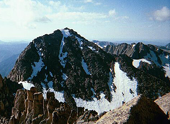
Windom Peak
|
|
Immediately after getting off the train, one crosses the
Animas River on a good foot bridge. The trail then runs south (right)
for a little less than 1 km to the point where the trail along the
Needle Creek heads east up the valley. There is a trail register near
this point. The trail climbs gently as it stays north of the creek.
This trail is about 10 km long. As it approaches Chicago Basin, there
is a smaller (less heavily used) trail that crosses the creek and heads
for Columbine Pass. Do not take this trail, but continue straight. A bit
further along the trail forks, there is a cairn at this point. The right
fork leads to a good (and popular) area for camping a short distance
further, while the left fork of the trail starts the climb towards
Twin Lakes. After the first hill this (latter) trail reaches a somewhat more
level area, this is the highest possible campsite. There is a sign next
to the trail at this point saying that camping is not permitted higher
up, including anywhere in the Twin Lakes basin. We established our BC
in this area, as high as possible given these regulations.
Second, from Base Camp in Chicago Basin to Windom Peak:
We did this climb after Sunlight Peak, see this entry for the first part
of the route. From Sunlight Peak, we crossed the basin going only slightly down
(in the direction of Twin Lakes) in order to get up on a field of rocks, thus
avoiding the snow. We followed the rocks up the slope and found the trail
(from Twin Lakes) about halfway up. This trail climbed the saddle and
continued among larger boulders up the ridge of Windom Peak. Some easy
class 2+ scrambling is required. One should note that the trail ascends to
the second saddle between Peak 18 and Windom (the one closer to Windom), that
is, the route does not climb the more distinct (and lower) saddle closest
to Peak 18.
Comments:
I did this climb with Pål Jørgen, 12 years.
We climbed this peak after descending from Sunlight Peak.
The summit is quite well defined also on this peak, but easily reached.
We noted that the USGS marker giving the elevation was located more
than one meter below the actual summit. It also gave an elevation that
is one foot (about 0.3 meter) higher than the officially recognized
elevation. We wondered somewhat if the elevation stated on the marker is
supposed to be the actual elevation of the marker itself or not. The
fourteeners are so close in elevation that such a small change would
change the relative ranking significantly.