Location: North 48.68193, East 090.72494 (GPS at the summit)
Difficulty: YDS class 2
Climbed August 22. 2019.
Information:
How to get there:
See the description for Khuiten Uul. for general info about travel to
Mongolia and to the town of Oglii.
From Oglii, head out of town in the south-east (corner/direction) and drive to location
N48.94872, E090.03783. The road turned pretty bad almost immediately. Continue
on this road as it turns more south and runs parallel to a river until one locates a bridge
at location N48.903, E90.140. Cross here, then turn north in order to enter a valley going
more east. Drive into this valley, then ascend to a pass at location N48.93734, E090.30181,
elevation about 2240 meter. After crossing these mountains,
you may get a first view of Tsast Uul
still quite far away. The route will continue towards it.
The track continues downhill, there is a fork where one
should bear right in order to enter a pretty big valley having (at least in summer) many
white huts, the characteristic circular GER that the Kazak normad population use.
You should pass near location N48.82281, E090.52770 in this area.
You should now see the mountain straight ahead on your left side (the left side of the
big valley.) A river is coming down a rather steepish valley on this side of the mountain.
Well before, there is a vehicle track/road that ascends (left) up a smaller valley. This is left
more or less immediately after passing a couple of Gers (huts). The road is steep and rough, high
clearaance and 4WD is needed. Higher up, the road curves right then continues a somewhät more
gentle climb in order to cross over the hill and descend towards the upper part of the
main valley, this is right below the slopes extending up to Tsast Uul.
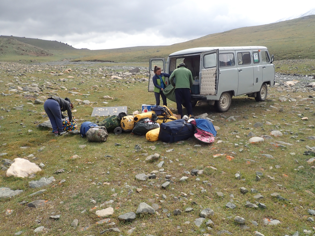
We left the track and drove down to the creek establishing Base Camp
at location N48.73189, E090.72556, elevation about 2720 meter. This location is pretty
ideal for climbing Tsast Uul.
Route description:
Cross the creek and head uphill in the
direction of the small hilltop having
glaciers on both sides. As the terrain becomes more level continue in the same
direction and locate a small trail that descends left into the small valley that
holds a second creek. Cross this and ascend (easy) out on the upper side. Change
direction more right and head towards the small valley that extends downslope from
the very pronounced glacier up on the right side.
This glacier looks steep, but is
much easier than how it appears from a distance. Cross a third creek and ascend
easy slopes on the right hand side of the creek/valley. The terrain is more
convenient for walking once you are well off to the right and quite a bit
higher than the creek. Head
directly towards the lower end of the glacier.
This location is N48.70547, E090.71787, elevation about 3250 meter.
Next, ascend this glacier. It is slightly steeper in the beginning, then more
gentle before a slightly steeper section at the upper end. There are very
few crevasses. The few were all very small and easy to detect.
The glacier above is much more gentle, almost flat as you turn left. Continue
into and up what almost looks like a small (glacier) valley. Gradually, ascend the
right hand side while also moving forward. You will reach the main ridge. This ridge is
quite broad and as you ascend it, it will curve slightly left.
Follow this broad and gentle ridge to the summit plateau. The summit area is quite flat
and a fairly large area has almost the same elevation.
Comments:
I had arrived in Oglii on Tuesday, August 20th. After a night in Eagles Nest Hotel, we had
breakfast and then left without much delay. The drive was interesting, with more tracks than
roads and absolutely no road signs. Clearly an advantage to have a driver that knows the area.
Our driver was actually from the Tsast area, an added bonus.
The car looked old, but was
a 2007 model, so only 12 years. It seemed to be the most popular vehicle in order to get
around. High clearance and wheels in the corners, the way it drove reminded me a bit about
my days driving a Volvo Jeep in the Norwegian Kings Guard back in 1969.
The drive took about 3 hours and our base camp
looked quite ideal with respect to climbing
Tsast Uul the following day.
We had breakfast at 0430 and started hiking at 0500. Progress was acceptable
and we reached the lower end of the glacier
at 0630. This location
was N48.70547, E090.71787 with an elevation of about 3250 meter.
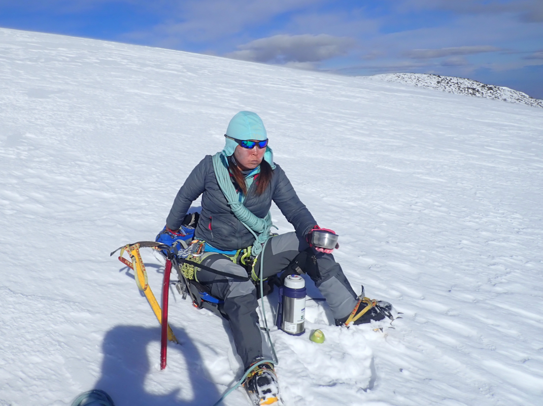
We continued up a fairly gentle and mostly crevasse-free glacier, higher up, it
steepened slightly and Ganga indicated that we might traverse left. However, I
pointed directly uphill and we continued that way. Here, it became appearent
that Ganga was moving considerably slower than what was comfortable. I made
repeated short stops in order for the rope to stay reasonably straight between
us. The snow got softer and we sank in about one shoe depth, the distance between her
steps was too short for me, while skipping every other step did not work well either.
Higher up, Ganga kept going uphill, while the obvious route would be to turn more left.
When I asked about the direction, she was quite annoyed telling me that this "is mine
mountain" and "I am guide". OK, none of us had been here before, perhaps it would be more
sensible to work as a team? It turned out
that she soon sat down and wanted to rest
and drink tea. I waited patiently until she was finished and we could resume the ascent.
I told her that it was quite hard work to break trail and that I could go in front and
share the work. After 5 minutes she agreed and I moved up in front. However, despite trying
to walk really slowly, I was still too fast for her. She then suggested that we proceed
without the rope. This looked quite safe to me, and soon I could break trail and make more
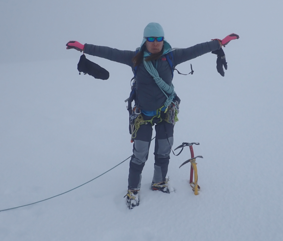
substantial progress. Higher up, the summit area was engulfed in a cloud that did
not seem to move much. I realized that we would have a whiteout, but otherwise the
conditions were just fine. I waited (quite long) for Ganga to catch up. She placed
her snowstake in order to mark the route. Shortly latër, she shouted to me that
the summit would be up on our right. I told her that the summit was still about
one kilometer left, along the main ridge. After some mild arguments she decided to
come my way. We crested the main ridge. What remained was just to follow it.
My (GPS) map turned out to have some significant inaccuracies. According to the
map, there should be 3 distinct summit "humps" along the ridge whereas the ridge
turned out to be completely "flat" while gently going uphill to reach the final and
correctly marked summit area.
Ganga was clearly uneasy with the whiteout.
She looked at me and said: "This is the summit, let us go back."
This was obviously not the case, we were still almost 500 meter short
of, and 50 meter below the summit.
The clouds shifted and we could see higher ground ahead along the ridge.
She then said:"I will wait here, you can go to the summit and then return to here."
I was slightly impatient with her by now, the best option would certainly be
to proceed to the summit together and not taking any risk for getting separated.
I had the route and our tracks in my GPS, returning together seemed much better.
She repeated that we should turn around and I told her that with a little patience
the clouds would shift and provide us with a bit of visibility - there were absolutely
no reasons for an urgent descent. I told her that turning here would count as an
unsuccessful attempt and that a second try tomorrow would be required. She said that she
would not try for the summit a second time.
The weather was basically nice and stable, we just
happended to be in a local cloud that hardly moved at all.
Finally, we both continued uphill, she followed me as I carefully walked the last
couple of hundred meters to the summit area. Here, the clouds briefly lifted just
enough for us to see the contours of the entire plateau. No views, but a good
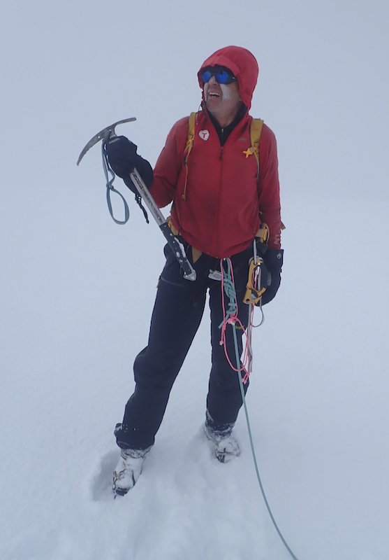
impression of this pretty flat summit area. The elevation reading was just below
4200 meter, in good agreement with the official 4193 meter.
The time was 1150, with all the stops and slow progress it had taken us almost 7 hours
to get here. A normal ascent should be possible in about 4 hours.
We took some summit photos,
but with little hope of any summit views, there were no
reasons to hang around much. We left at 1200.
The descent was much quicker, we continued unroped all the way and I returned to
camp at 1430, so 2.5 hours.
Ganga arrived and immediately asked for a beer. I suggested that I could do
a solo climb the next day. She immediately supported my suggestion.
The support and the logistics for this trip was excellent. I wish to thank Ganga for organizing everything
so very well. The driver and the cook were both extremely helpful and always smiling and contributing
to a good spirit. The food was excellent and prepared in a flawless manner. This report continues with
my ascent of a Taz Uul the next day.
Resources:
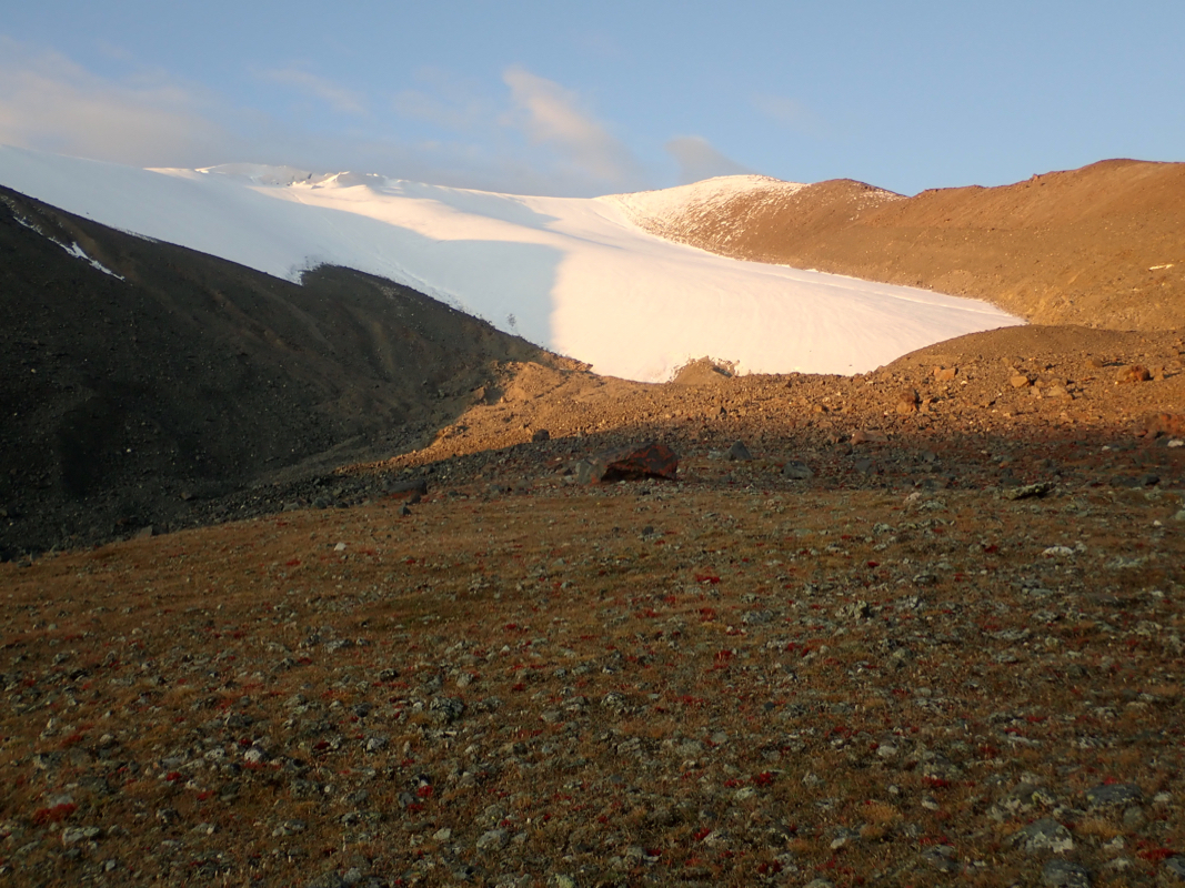
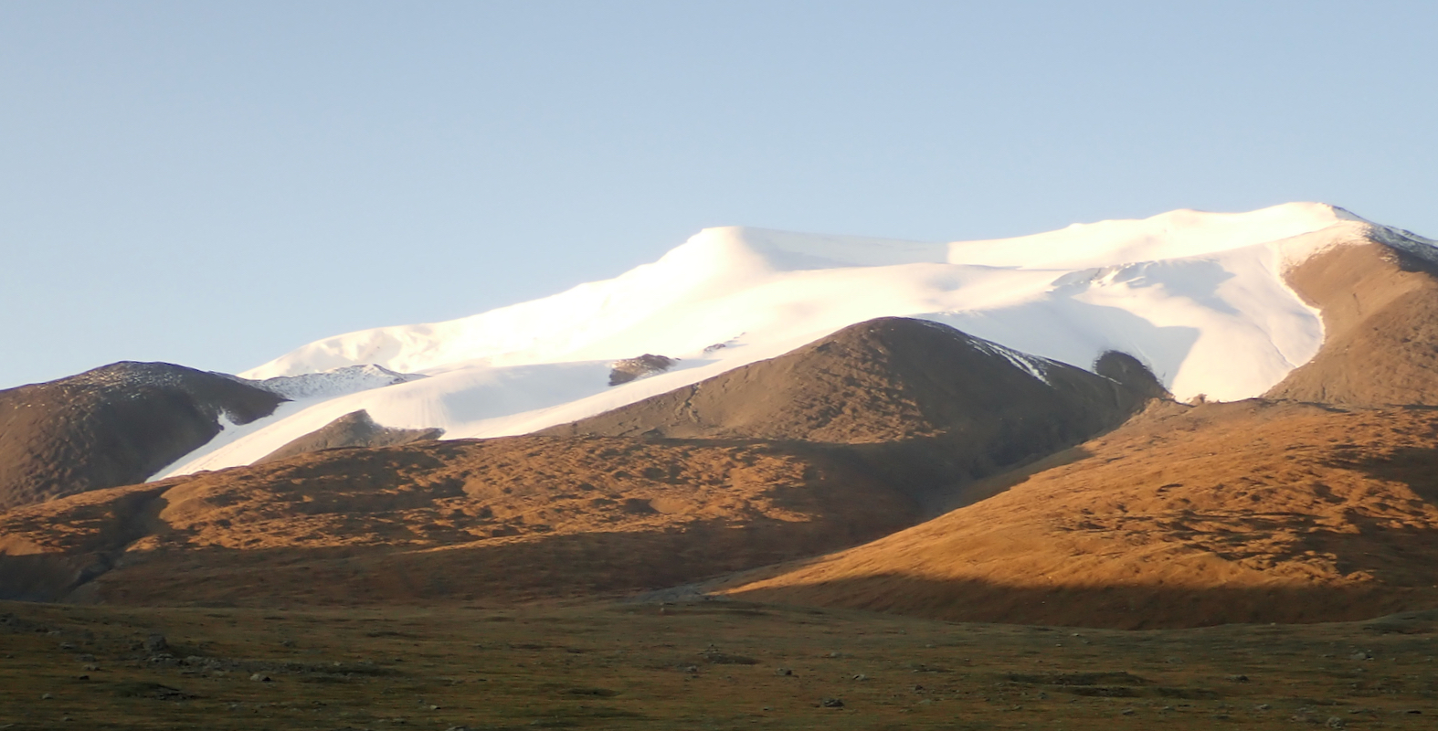
Images
Tsast, from base camp in morning light. The summit is
clearly seen to the left in the picture.
