Khüiten Uul
- Khüiten Uul
- 4356 m
- Primary factor 2324 m
- Mongolia
- Location: North 49.14957, East 087.82518 (GPS at the summit)
- Difficulty: YDS class 2+
- Climbed August 28. 2019.

Khüiten Uul
|
|
We came back from Tsast Uul shortly before noon on Saturday, August 24th. It turned out that all rooms in Eagles Nest Hotel were booked, but we stayed there until the rest of the team was due to arrive at 1700. The group arriving from Norway were:
Lars and Aud
Johnny and Stian
Petter
Alarming news, Johnny, Stian and Petter had
lost their baggage (left behind in moscow). Emergency purchase of
essential equipment was high on the priority list.
We spent the night in a place in the outskirts of town were accomodation was in the
traditional, circular white huts called ger, Two beds in each ger and plenty of space.
I shared with Petter and he borrowed my mountain jacket, a wool sweather, long wool underwear and a
warm mountain hat for the rest of the trip.
Petter is a very accomplished mountaineer and trail runner. He had already visited about 120 national
highpoints all over the world.
I looked forward to meeting Petter, the last time was almost 10 years back when he asked me to
provide some advice on climnbing Mount Logan.
Sunday, August 25.
We left around 0800, the drive to the national park should take about 7 hours. Mostly,
we drove in a large flat valley with low mountains on either side. Gradually, the valley
got more narrow as we ascended to about 2500 meter. While we were still on the larger, flat
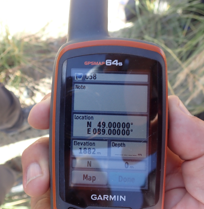
area, we made a stop and visited the spot where the 49th parallel crossed the 89th degree
longitude. This location
was only 75 meter from the driving track and we built a small cairn
there to mark this somewhat special point.
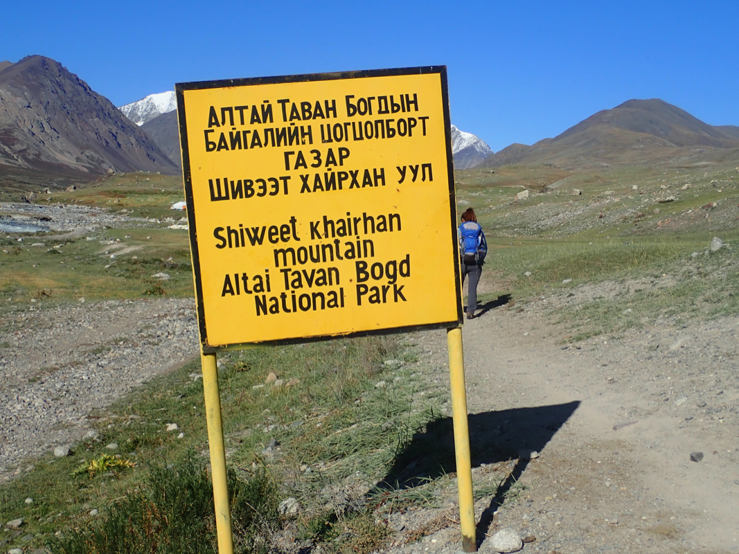
We arrived at the White River National Park entrance
early afternoon and established camp there.
Monday, August 26. trek to Base Camp
An easy and pleasant trek to Base Camp.
Quite a short day.
We stayed in our three very new North Face tents and Ganga had rented a local Ger for
common space, meals etc. Again, very well organized in all respects.
Tuesday, August 27. hike to High Camp
Another nice and easy day. We hiked along the trail towards Malchin. Before the last
stretch to the hillside of Malchin, we turned left and crossed the moraine to enter
the glacier. The glacier was very nice, a very gentle slope and virtually no
crevasses. The porters took their two horses up this glacier until they started
to step into (smaller) crevasses typically hidden by the thin top layer
of snow. First time I have actually seen horses on a glacier.
We established camp very near the base of Khüiten,
the ascent would be a rather short trip. This location was
N49.16491, E087.83559, elevation 3780 meter.
Wednedsday, August 28. Summit Day
Despite this being a very short summit day, Ganga insisted on an alpine start, ie. to
leave with headlamps well before dawn. The team was not very happy about it and we ended
up leaving at dawn.
We left on two ropes with Ganga and her assitant guide, first crossing the short flat stretch. We had
to break trail and it was more work to walk up front. Johnny was number two and after a short
while he needed to take off a layer and at the same time we agreed to switch positions. We found
some rather minor crevasses on the first part of the hill. Again, quite remarkably, the guides
made a lot of fuss about this. The crevasse(s) were really trivial, but brought us to a full
stop with Ganga walking around with her probe. It certainly looked as if they tried to create
a bit of drama for inexperienced tourists.
After this, we continued uphill following a line that looked good, but with several stops, mainly
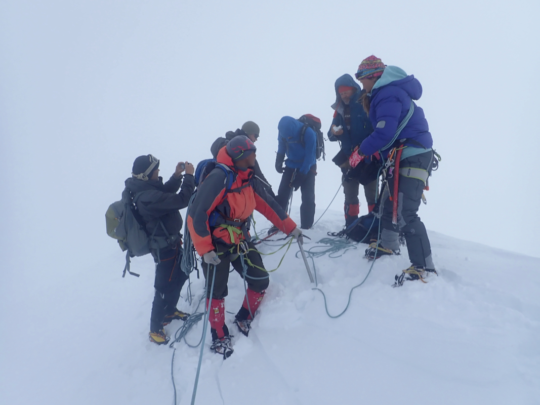
to have the rope that Ganga led catch up with us. As daylight came, we could all see that the summit was
engulfed in a ´cloud. Things looked pretty similar to my ascent of Tsast in this respect. We gained more
gentle slopes and walked along the first part of the ridge with limited visibility. However, it was
pretty clear that the right hand side slope was safe, the left hand side could be corniced and therefore
deserved respectful distance.
Quite soon Ganga stopped and declared that we had reached the summit.
I was taken by surprise, my GPS showed that the summit was still almost 500 meter
away and about 30 meter higher. Everything
reminded me about Tsast Uul, we had a white-out
and Ganga said "this is the summit", when my GPS said that we were not yet there.
The single (but important) difference was that she had indeed been here a large number
of times. With all hindsight, I certainly should have taken this more into account.
When I asked if we could explore the ridge a bit further onwards, she really got
furious, I would say quite an overreaction. Anyway, walking further was clearly
out of the question.
We all assembled, taking
care to stay on the safe side of the ridge.
Aud had a rather lengthy summit ceremony, but at last we could
start the descent.
There was absolutely no need to hurry and it would have been
a trivial and completely safe matter to walk another 500 meter along the ridge.
The descent was very easy and as we got back down towards the flat base area, Ganga
suddenly told me that we could return up once more if I paid her 1000 US dollars!
I must confess that this is one of the stranger moments that I can recall. Utterly
strange and obviously something I immediately turned down. We were back to the tents around
1100.
The weather was now clearing, the cloud on the summit was quickly going away. It would have
been perfect timing to start after daylight and perhaps stay up near the summit for some
longer time, we had no wind and comfortable temperature up there.
What now? Johnny, Stian and Petter wanted to return to Base Camp, they departed about one
hour later with the assistant guide. The weather was now gorgeous and it would have been
a completely trivial matter to do another climb to the summit, most likely a 3 hour round trip
if I had done it solo. The plan was now to do nothing, then climb the tri-border point located
a short way across from our tents, as well as its slightly higher neighbor peak. I requested
that I would then also climb Malchin (solo) on the way back to Base Camp.
Thursday, August 29. Minor peaks, return to BC
We woke up to another brilliant day. Lazy morning, but we eventually got
going. We were supposed to visit the triple border point between Russia, China
and Mongolia, then cross over to the nearby slightly higher
peak whose name appearently means Russian Tent. The short and flat glacier
crossing was completely without crevasses. We still roped up and used crampons,
both measures without any merit.
We were on the first hump around 0815 and after time for pictures and good looking around, we
next ascended the higher neighbor peak around 0930.
The hike up there was short, but the views were equally good.
Thus, we got the good view into the two neighbor countries that
we missed on the summit of Khüiten. Returning to camp already around 1000, we now
had more idle time, this trip indeed had very easy days.
More than plenty time for making a quick dash up on
Khüiten, but of course, this was impossible since we were here with a guide.
We departed for Base Camp and near the lower end of the glacier, Ganga advised that
I could proceed directly to Malchin. Before that she had led us down on a path that
deviated from the normal route (also used by the porters), this led us into more
crevasses. Lars stepped through 2-3 times and Ganga stepped into a crevasse herself.
Read a short report about Malchin here.
Friday, August 30. Russian Border peak
Today was the spare (extra, weather) day.
I decided to explore the hill just behind base camp. This turned out
to be a pretty long trip,
much longer than planned. First, I ascended the
local summit and located the highest point with a cairn. I realized that
the Russian border ran on the next ridge over, a deep valley coming in from
my right (south) separated this ridge from where I was. Moreover, the elevation
across there looked similar to where I was. I decided to descend to
the shallow pass and measure to see if my top had more than 100 meter
of prominence. If yes, I would hike back to camp. The prominence turned
out to be only 80 meter, thus a visit to the other ridge would also be
needed. I first hiked across in order to find the Russian border, then parallel
along it to the far away summit point. Finally there, my GPS measured exactly the
same elevation as on my first summit. I paid a visit to the nearby border post, then
turned home. The best route seemed to be descending into the small side-valley
between Base Camp and Malchin. This was indeed a good route and I finally returned
after what turned out to be a pretty long hike.
Saturday, August 31. Trek out and start return drive
The return trek was actually quite nice. We crossed over the main crest
(left as we were trekking) and descended into the valley that i had seen
from my trip to the Russian border the previous day. We then drove about 3
hours and camped on nice grass right next to a river. There were Yak ox in the
same area and two of them engaged in a fight lasting several hours to decide
who would be the next leader of the herd.
Sunday, September 1. Back to Oglii
A fairly short drive, about 4 hours. We made a stop at some
Ger where they had captured an eagle. This was not nice, better
to release the eagle, a first step would perhaps be to NOT
visit this family until the eagle is not there anymore.
We checked in at the Eagle's Nest Hotel. A quick look at the GPS reading
from Eric Gilbertson (2016), confirmed what by now seemed pretty clear,
we had indeed visited the highest point of Mongolia. Eric's GPS read only
4348 meter, in pretty good agreement with my readings. This is clear evidence
that the former official elevation of 4356 meter is correct and that the "NEW"
official elevation of 4376 meter is wrong. It would be interesting to know
how this change (from right to wrong) came about.
Monday, September 2. Oglii, then fly to Ulan Batar
Lazy morning, then a trip to look aound town. Not much to
report here. We were all eager to go as time approached 1700.
The flight to Ulan Batar was on time and after some slight
confusion, we all had rooms at the not so close, airport hotel.
Early morning departure, we needed to leave the hotel shortly
after 0500.
Tuesday, September 3. Fly to Norway.
The flight from Ulan Batar via Moscow and Oslo to Bergen went according
to schedule with no unexpected incidents.
Afterthoughs
Many thanks are due to Lars for organizing this trip, I know how many
details one needs to keep in mind. It was indeed a luxury to just show up
and participate. Thanks also to Petter with whom I shared rooms and tents,
it was nice to get to know you better. Thanks to Johnny, Stian and Aud for
good company.
Ganga deserves a big thank you for her organizing everything very well.
The accommodations, the transport, the tents and the food were all excellent
and can be highly recommended for future parties.
Personally, I would have preferred to do the mountaineering part without the
guide(s). They (almost) always act as you are a novice tourist with close
to zero experience. She certainly showed little experience with crevasses
and generally walked too slowly. I have experienced a fair number of
guides in Asia and Africa that do not have the samne precise concept of
what constitutes the summit as we do in Europe and the US. Contributing to
the confusion at the summit was the fact that Mongolia now claims that this
peak is 4374 meter while the correct elevation is at most 4356 meter. However,
it is clear that the summit is located where Ganga stopped, my experience from
our previous peak and the incorrect data led me astray on this point.