How to get there:
The nearby city of Buena Vista, 33 miles south of Leadville, is a natural
starting point. All guidebooks tell that one should go west on
the road oppsite the Pizza Hut (0.4 miles north of the trafic light).
However, this road was closed when we were there. What then? It turns out
that one can also go west in the main city intersection (the one
with the only traffic light in town). Route description:
The route first follows the creek, mainly on the left hand side,
up the valley. Just after crossing back to the right hand
side of the creek, there is a trail fork where one should take
the right branch, heading up to the upper basin. The trail gradually
becomes less steep in this upper basin. Mt. Columbia lies to the right,
while Mt. Harvard is right ahead, slightly to the left of center.
The trail climbs towards the left ridge (to the left oif the summit), then
angels up to the final summit block. The two mountains are connected
by a fairly long and rugged ridge called Rabbit Ridge. The "rabbit" is
a specific rock formation on top of this ridge, easily recognizable.
Comments:
Pål Jørgen, age 11 and Jenni Søbstad (age 20) did this
climb with me. It took us 4 hours from the car to the
summit. We proceeded with a complete traverse of the
Rabbit Ridge connecting to Mount Columbia, (see description
of this traverse under Mount Columbia).
Total hike was 9 hours and 20 minutes including generous
resting time on Harvard, along the Rabbit Ridge, as well
as on the summit of Columbia.
Resources:
Images
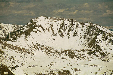
Mount Harvard seen from the summit of Mount Yale on April 29. 2001.