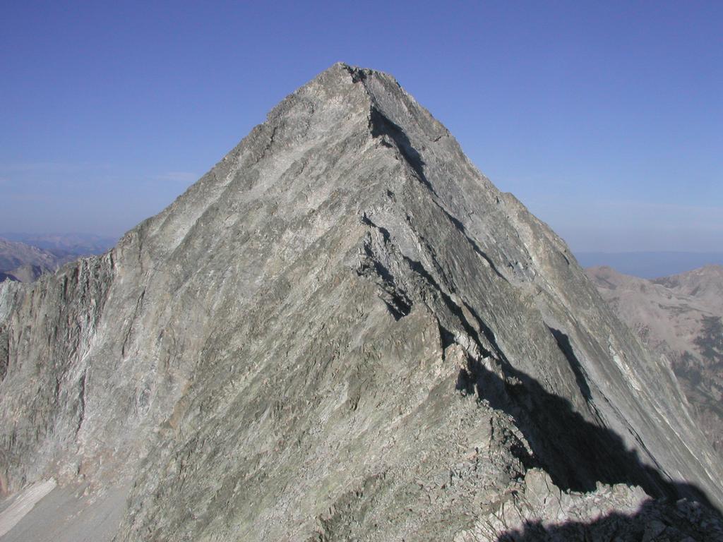
Capitol Peak
- Capitol Peak
- 4307 m.
- Primary factor 533 m.
- 29th in Colorado
- Location: North 39:09.017, West 107:04.983
- Climbed July 19, 2002
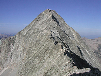
Capitol Peak
|
|
Route description:
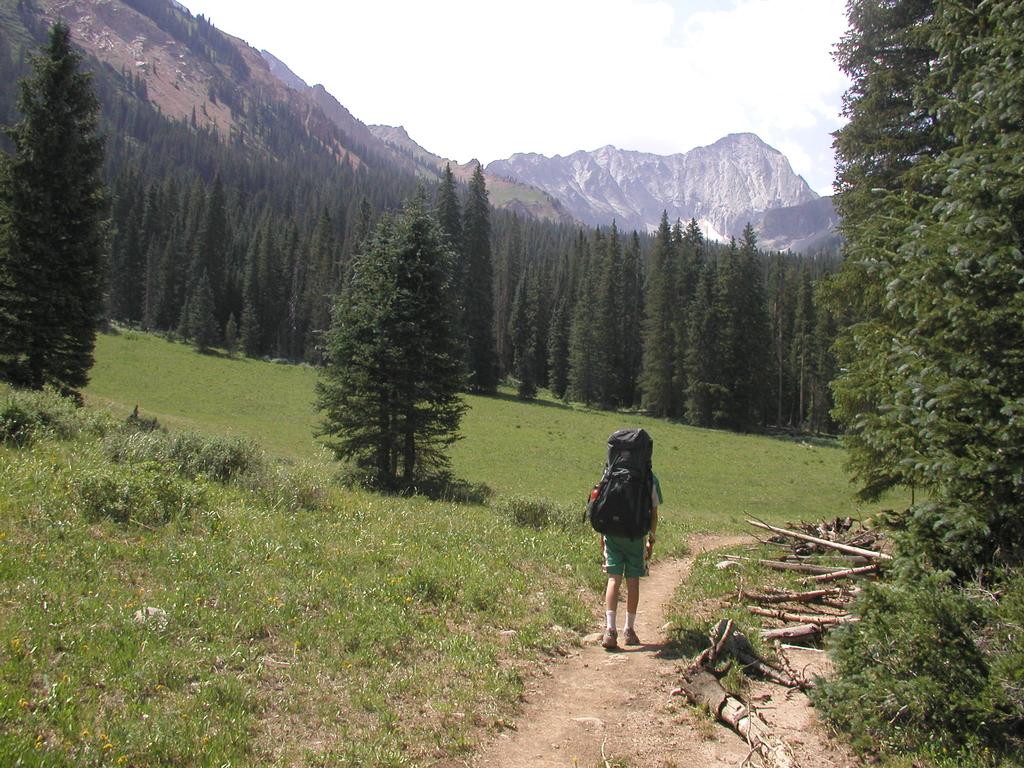
First, to Capitol Lake:
From the trailhead one already has a clear view up the vally with
Capitol Peak at the upper end. The valley from Capitol Lake is directly
across as you look south. The valley bends east right in front of you.
The traditional trail descends to the
valley floor crosses the creek and takes you up the valley on the east
(left) side of the creek. This involves a substantial loss of elevation as you
start hiking.
A better and also more scenic trail starts out at the north-west corner
of the trailhead. This trail will curve around the valley (to your right)
and join the first trail about half way up the valley. It is slightly
longer, but this is easily compensated by the scenic views and the
fact that you do not start out with a big loss of elevation. This trail
is sometimes called the "ditch trail" as it starts out very level
along an old irrigation ditch.
Follow the ditch on a very nice trail that is completely horizontal as it
curves around the valley keeping the elevation. After a while the ditch
will continue straight while the trail leaves uphill to the right. There is a
clear sign saying "trail" at this point. The trail crosses the only
significant side valley with its corresponding (small) creek on good
stepping stones, then continues into more open fields ascending until
a hilltop with some trees followed by another open field where the trail
starts a gentle descent into the Capitol Valley. The trail hits the
valley floor about halfway to Capitol Lake. The Capitol Creek must
be crossed at this point. There was not too much water and the creek
could be jumped, there was also a log that spanned the creek at this
point. (This was a dry year, earlier in the summer this creek could
possibly be a bit more tricky to cross without wading, perhaps in particular
going the opposite way.) The trail now continues up the valley. Soon, there
is a signed trail climbing east called West Snowmass Trail, continue along
the main trail following the valley. The trail passes meadows with flowers and
small sections of trees as it climbs, first gradually then steeper towards
Capitol Lake. At the end the climb is more substantial and one crosses
the creek a couple of times. The lake itself is hidden from view behind
a few knolls as one climbs the final slopes. There are isolated groups
of trees in this area with nice campsites. We stopped at such an area
just north of the lake and very close to the trail junction where the
Capitol Peak trail goes left from the trail to the lake. This campsite
was located at North: 39.09.944, West: 107.04.896.
Second, from Capitol Lake to Capitol Peak:
The trail to Capitol Peak takes off across a huge meadow full of wild
flowers sloping up towards an obvious saddle. When we were there the
Colorado Fourteener Initiative had some volunteers working on making
a better (zig-zag) trail to the saddle. This saddle is easy hiking, but then
there is almost no more trail to follow. Just beyond the saddle, the trail
will lead you slightly right and into a loose gravel gully that descends
steeply towards the basin below. Follow this gully down until it is easy to
continue right. The route is now in the valley (west) across rocks and boulders.
As you gradually climb through the boulders staying left of more difficult
terrain, you will see a snowfield higher up. Pick your course to the
right of this and gradually a small, but distinct cone shaped summit
will come into view. This is K2 and the approach part of the climb is
over when you are there.
In order to gain the summit of K2, one can either climb a short rock
ridge directly or climb down a couple of meters to the right (solid rock)
then immediately regain the small summit (YDS class 3).
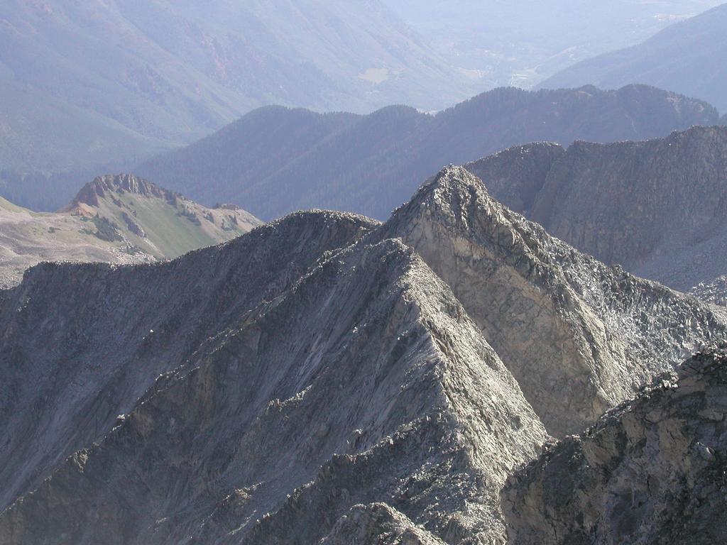
From K2 one can see the ridge connecting to Capitol as well as the area
of the remaining route. The terrain in front of you looks complicated.
Descent north (to your right) among larger rocks on a small, but clear
ridge line. This down climb is easy scrambling. Continue down until a
clear and easy route leads you back to the ridge connecting K2 and Capitol.
Some people try to avoid K2 by traversing directly to the ridge north of
K2. While possible, this looks unpleasant and not worth the small saving,
the summit of K2 should be part of this climb.
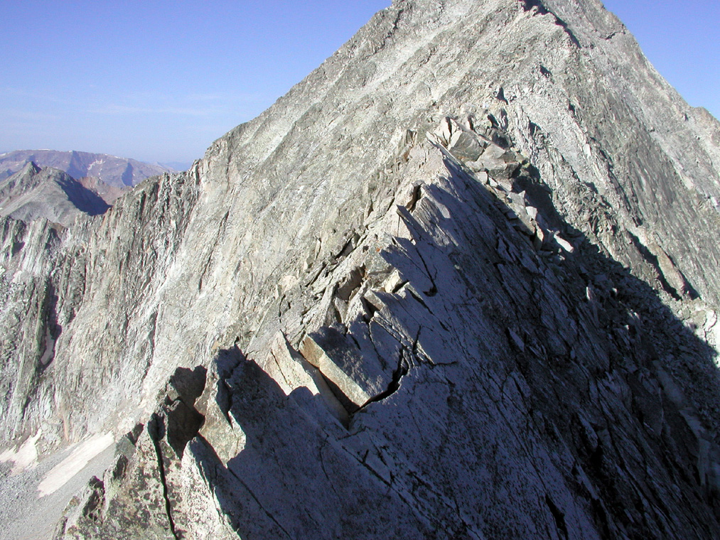
You are now on the ridge. The first point of interest is where you get a
great view south-east to the Pierre Lakes and the general area towards
Snowmass Mountain. You will soon find that the ridge narrows and a small
mini-knife edge appears. This is easy as you have a small, but perfect
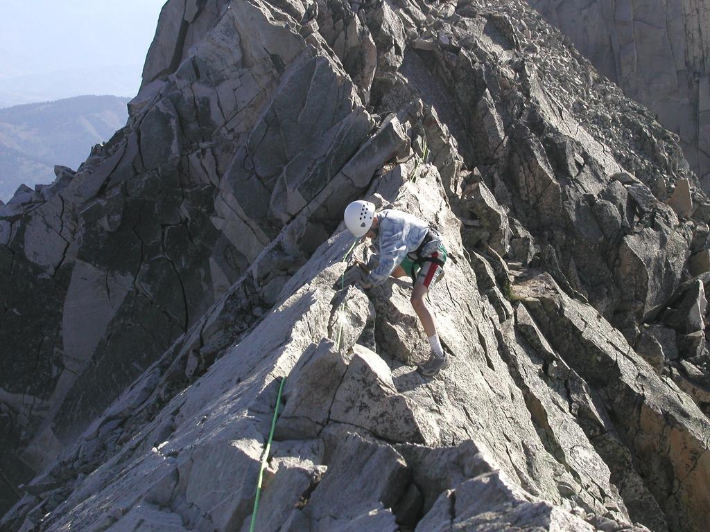
ledge to walk on as you hold on to the top of the ridge. Next, is the
famous Knife Edge. This section of the rock is impressive, but
technically quite easy. The north sloping part is very smooth rock
(you may see Capitol Lake deep below), however, the south sloping
part has more irregularities. The best technique is to generally
stay on the south side and hold onto the top of the ridge. There are
several places along the way where one have reasonably good footing.
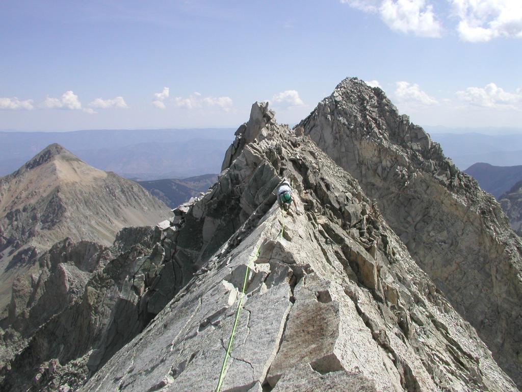
The very last part of the ridge gradually becomes a bit wider and one
can complete the crossing on the very top of the ridge.
Much route finding remains. Continue across the now wider ridge and start
out climbing as you move on to Capitol proper. One can continue more or
less directly on the ridge to the summit, this is continued class 4. The
easiest (but perhaps somewhat less safe) route enters the south-east face
of Capitol. First traversing across a fairly distinct gully, then gradual
ascent as you cross over into a second, somewhat wider gully. There are
loose rocks and scree in this area, move carefully. As you enter the
second gully, climb up and move back to the same area that you entered from,
but higher. Continue to climb up among better rocks (with the wider
gully still on your left) then find a good ledge that crosses the gully
quite high up. The route will now get you onto a fairly distinct ridgeline
coming down the south-east face beyond the wide gully. This line has better
rock and one can ascend up towards what may appear to be the summit. Higher
up this ridge line becomes less steep and a clear zig-zag path leads the way
back to the main North-East Ridge of Capitol. What appeared to be the
summit is just a point on the ridge, however the main ridge can be
followed without much difficulty from here to the summit. The route has
good exposure, especially to the north (right), but the large boulders and
rocks along the ridge appears to be quite stable. Pick your way and soon
the summit is there.
Note: There are obviously many variants in this
south-east face. Several of these are (at least partially)
marked with cairns. What has been
described was reasonably well cairned and seems like a good compromise
between the loose (and dangerous) face and the better rock along the
ridge. Each party must use their own best judgement.
Comments:
I did this climb with my son Pål Jørgen, age 13.
We hiked from the Capitol Creek trailhead along the upper, more
scenic "ditch-trail" arriving Capitol Lake at 1215 after 2 hours
and 45 minutes of hiking.
We started from a camp near Capitol Lake the next morning
at 0535 and reached the
summit after 3 hours and 55 minutes. We rested and enjoyed the
views and solitude for about 15 minutes. We were back at the
summit of K2 6 hours after the start, so it took one hour and
50 minutes to climb back.
We subsequently reached the tent after
7 hours and 15 minutes at 12:50.
Pål Jørgen crossed the Knife Edge using a sling attached
to a rope for safety. One climber passed us on the way up, it is
possible that two climbers that we met when returning across the
Knife Edge also made it to the top. A party of three climbers turned
back without reaching the summit.
We departed from our Base Camp at 1355, reaching the car at 1600,
only 2 hours and 5 minutes on the return hike. Thunder and rain
started at 1602...