Location: North 46.5521, East 8.4063 (need improvement)
Difficulty:
Climbed August 1974
Information:
How to get there:
Drive to the Furka Pass in Switzerland, this is one
of the main highways crossing a major mountain pass
in the Alps. Park there. Route description:
We hiked south from the Furka pass (2429m), then west and established
camp
on a nice grassy hillltop at elevation 2510 m.
From this camp we had a nice view of
Oberwald
to the south-west.
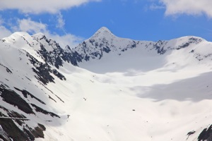
Rhonegletscher
dominated the view to the north. The
north-west ridge
of the mountain extends down to this point.
The ridge requires some
scrambling
(YDS) class 3 and provides a nice view of
Galen (3583m)
on the north side of the Furka pass.
The last ridge
before the summit is easier and
Sverre, Jostein and Petter
have climbed their first Swiss mountain, 3099 meter. We met
two natives
on the summit, and we all enjoyed the view (west) of the Alps.
The view south
was also quite nice as well as
east towards Andermatt. Comments:
We had a nice view down the glacier on
the northern side. This was mid summer, but
quite an out-of-the-way place. We did not
see many other hikers. Campers watch out
for angry Swiss climbing cows! We had a tent
a tent ruined
while on this climb.