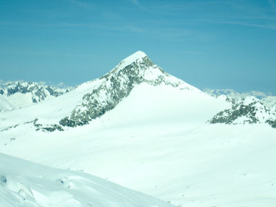
Keeskogel
- Keesk0gel
- 3291 m
- Primary factor 376 m
- Hohe Tauern, Austria
- Location: 47.13650, East 012.31179 (GPS on the summit)
- Difficulty: YDS class 2
- Climbed April 19. 2018
Keeskogel
|
|
How to get there:
The starting location is the small village named Neukirchen am Grossvenediger. This town
is located along Hwy. 165 going west from Mittersill. You get to Mittersill by travelling west on
Hwy. 168 from Zell am See. Zell am See, in turn, is reach via Hwy. 311 going south then west from
Bischofshofen. Bischofshofen is near A10 south of Salzburg.
As you travel west from Neukirchen am Grossvenediger, turn left only a few hundred meter after
leaving town, on a smaller road serving Sulzau. Pass through this tiny farm community, heading for
the valley that exits towards this plain. Turn right and cross a bridge (the river), then head
left (south) as this forest road climbs into the valley.
In April, the road was closed already at location
N47.22382, E012.24481, elevation about 940 meter, where there is limited parking on the left side.
This is just opposite the location of a small quarry.
Note that later in the season, there are more transport options, see below.
Route description:
Hut climb:
First, follow the road to the border of the national park. There is a good sized
parking lot here. Thus, later in th season (mid May?), one may drive to, and park
here. This location is N47.19330, E012.26182, elevation about 1300 meter.
Later in the season when the road is ok further up and into the valley, there is
a taxi service that have permission to drive people a lot closer to the
Kürsinger hut.
In winter (spring), the route follows the road and there are two distinct
uphill sections in this valley. After the first uphill where the road
climbs in zig-zags, a more level section follows and one arrives at the
Postalm hut. This is a good starting point for a climb of Grosser Geiger.
Next, the valley has another step before you enter the last, more level
section that runs below the Kürsinger hut. One follows the valley
to its very end where a steeper section climbs to reach a very distinct
(glacier) lake. The glacier used to be here, but after retracting a lake has formed.
One must cross this lake, then turn left there is a slighly shorter route that
ascends a gully or one may ski a somewhat larger arc and have a more
gradual climb. The route continues to find its way uphill while tending left
until it reaches its highest point at location
N47.12280, E012.30517, elevation about 2620 meter. From here, follows a descent (down left)
in order to reach the Kürsinger hut, located
at N47.12257, E012.29986, elevation about 2550 meter.
Route description:
Starting from the Küstinger Hütte,
Comments: