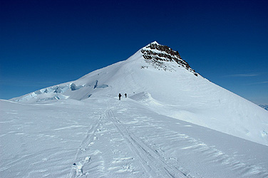
Hvitserk

  • Hvitserk, Gunnbjørnfjeld (Gunnbjornfjeld)
  • 3694 m
  • Primary factor 3694 m
  • Location: North 68:55.170, West 029:53.912 (GPS on the summit)
  • East Greenland
  • Greenland HP
  • Highest in The Arctic
  • Difficulty YDS class 3, French Alpine PD.
  • Climbed May 17. 2004.

Information:

How to get there: The normal approach is by a ski equipped Twin Otter airplane directly from the small town Isafjordur on Iceland. See my Greenland pages for more extensive information.
Route description: From our Base Camp (pretty standard location, elevation about 2200 meter), the normal route is up the glacier to the south side of the summit. This glacier is relatively free of crevasses on the left (south) side when viewed uphill. The slope is gentle and very nice for skiing. Higher up, there are a couple of large crevasses, however, one should have little trouble in finding safe snowbridges. Continue to the right of the lowest col and climb the gentle south ridge that extends out from the base of Hvitserk. There are a couple of rock outcrops on this ridge. The distance from base camp to this ridge is about 7 kilometer.
Ski along the ridge until the slope steepens. From here, climb directly up the first slope until a somewhat more level area forming the top of a small gully that heads down left. Continue up on slightly steeper snow (protected by this flat area below you), then traverse up left in order to gain the ridgeline above you (and avoid steeper terrain and some rocks straight up). Once on this ridge, which is really the right side of a broader slope, continue directly up until you reach a more level area. This slope is perhaps up to 40 degrees. Continue along the ridge on easier terrain to the summit plateau. The highest point is a snow summit at the far side from your point of arrival. On good snow, this route is about (YDS) class 2+ in difficulty. However, conditions can clearly change and if the slope is icy, then a rope may be needed to safeguard the climb.
Comments: The complete team of 6 made the summit in about 6.5 hours from our base camp. With a vertical gain of about 1500 meter, an early start is essential if the temperature is as low as we experienced it (around -30 Centigrade at night). On Norway's National Day, we enjoyed almost a full hour on the summit, with no wind and a warming sun. We were on top around 1330 GMT, the warmest period of the day. Per Ove and Torstein carried their Telemark skis to the summit and proceeded to ski all the way down the south ridge, partly on the south-west slope, making excellent turns in deep, dry first class powder. This was the first ski descent from the proper summit of the highest mountain north of the Arctic Circle, a better celebration of the 17th. of May is hard to imagine!

Resources: