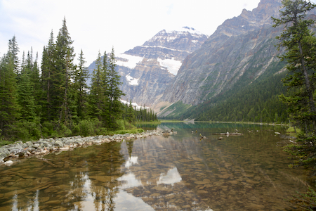
Mount Edith Cavell
- Mount Edith Cavell
- 3363 m
- Primary factor 2033 m
- Alberta, Canada.
- Location: North 52.66698, West 118.05357 (GPS on the summit)
- Difficulty: YDS class 3
- Climbed August 5. 2018
Mount Edith Cavell
|
|
How to get there:
Route description:
From the hostel, walk back down to the road, cross it and
take the shortcut that reconnects with the (side)road a bit
lower. Cross the bridge and take the wide path that first
climbs slightly, then curves around to your left in order
to follow the hillside. This path is quite big and well
developed. As you get closer to the mountain ahead, ie. can see
that a (side)valley will branch left, then pay attention in order
to locate a (smaller) trail that forks left. If you cross the
river, you have gone too far. This is about 4 kilometer from
the trailhead were you started.
Take this very clear trail that heads uphill (left) from the
main trail. The trail runs through old forest, breaks out near
the tree line, then runs through sections of younger (smaller)
trees, before turning more uphill and engtering a nice, open basin
with gras. The big slope with talus and rocks is looming ahead.
You may notice a faint trail that leads across the first section
of rocks, then uphill. Do the initial climb on the left side
of the creek (in the middle), then cross to the right at a pretty
obvious location. Thus, the major part of this ascent will be
to the climbers right hand side of the creek. A rock-rib extends
uphill, it provides more stable rock and ascending on it is
recommended. There will be several small cairns indicating
a good route.
Higher up, the rocks are quite unpleasant, many medium sized rocks are quite
loose and unstable. One should be careful in this area if there are climbers
below. Ascend up this final stretch to gain the main ridge.
Turn right and foillow the broad ridge, the best rock is often staying left
close to the steep drop on that side. Higher up, it is easy to see that the route
becomes (too) steep and a traverse right, to reach the ridge
Comments:
I did this climb with my son Pål Jørgen. We had a reservation
at the hostel, since the road was closed, except for people staying
there. We arrived the evening before and enjoyed a nice evening before
sleep.
The next morning, we were up early and left by 0600. Pål set a good pace
and we arrived at the trailfork by 0640.