How to get there:
This is quite a popular trailhead serving a nice camping area
with frequent visits.
The Trophy Mountain area is an addition to the southern boundary
of Wells Gray Park, just northeast of Clearwater.
The area is accessed via 11 km of gravel logging road (Bear Creek Correctional Centre road),
branching from the Clearwater Valley Road north of Clearwater near Spahats Creek Park.
Trophy Meadow trail allows visitors to access the alpine meadows and basin of the Trophy Mountains,
in less than a one hour walk from the trailhead.
Drive this road to the end, there are information signs and a large area for parking.
This location is N51.75845, W119.94283, elevation about 1680 meter.
Here is a summary of climbs in Canada, August 2022,
Route:
A big and quite popular trail connects this trailhead with a designated
camping area near some smaller lakes. Follow the trail to this area and continue
a bit more. You will have the west side of the West Trophy south ridge up on your
right hand side. Leave the trail
and scramble up to the top of this ridge. The steepest part is near the end, there
are multipe (local) routes, all about (easy!) (YDS) class 3.
After reaching the ridge, just go north on very easy terrain to find the summit.
Comments:
We slept near the trailhead and started hiking already by 0610.
I remarked to Adam that I felt pretty bad this morning, but that these
symptons likely would go away once we got going on the trail.
It was a very nice morning, the first few miles of this trail is quite
popular, many people hike into a well organized camp site near a few small
lakes. We soon came to open meadows with alpine grass and flowers. I was still
not feeling great, but progress was reasonable. We left the trail and scrambled
up a steeper hillside towards the south ridge of West Trophy Mountain.
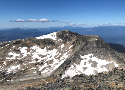
After a brief visit to the summit of West Trophy Mountain, we started the
scramble traverse towards Trophy.