Kispiox Mountain
- Kispiox Mountain
- 2096 m
- Primary factor 1561 m
- British Columbia, Canada.
- Location: North 55.39855, West 127.94349 (GPS on the summit.)
- Difficulty: YDS class 2
- Climbed August 21. 2018
Kispiox Mountain
|
|
How to get there:
This mountain is quite a bit north, travel to Prince George, then take Hwy. 16 continuing to
Smithers and onwards to New Hazelton. Leave the Hwy. here and drive through Hazelton, then north
on Kispiox Valley Road
to Kispiox. Do not cross the bridge, but continue on the left side of the river on
Kispiox Westside Road to location N55.38283, W127.71493, where you continue right
on a forest road. At location N55.40085, W127.75649, keep left (straight). Continue, generally
keeping to the main road, eventually, it will start going uphill (drivers left) in
big curves.
Thus, after quite a long drive on this forest road you should get to a road fork
at location N55.45944, W127.90179. Keep right (straight) here and continue to
the end of the road. This is the best trailhead, as a trail crossing the
forest area begins here.
Route description:
If you start from the recommended trailhead, you should be able to
follow a trail through the forest area until it emerges into open,
quite beautiful meadows. Continue along the trail to gain a pretty
obvious ridge that connects with the main mountain ahead. The trail
will take you all the way to the main crest from where you see Kispiox for
the first time. Moonlit mountain is now directly uphill to your right, however
it is perhaps most natural to bag this summit on the return hike.
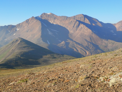
Looking across, you quickly see two ridges that connect up to the summit
of Kispiox. The left (most direct) ridge appearently has some difficulties
near the summit, thus the safe route to follow is the ridge visible
more to the right. There are moraine terrain at the valley floor. It is
best to descend right and stay on green (vegetation) terrain in order to
reach the base of the ridge. This involves loosing a bit more
elevation, but this is still highly recommended.
As soon as you reach the base of the ridge, ascend first on steepish and
somewhat loose talus in order to reach a smaller summit from where the
ridge proper starts. There are signs of vague trails zig-zaging up this
talus slope. From the first local top, follow the ridge to the summit,
sometimes staying slightly on its right hand side.
Comments:
After a very nice climb of Cronin, we drove up this long forest road planning
to camp at the trailhead. We drove left instead of right at the last fork, believing
that this branch would get us slightly higher. However, the road turned so bad
that we decided to turn the car and camp about 100 vertical meter below the end
of the road. The time was 1900 and we were ready for an early night.
The next morning, we were off already at 0630. Higher up, leaving the end of
the road we had to bushwack through the forest above. Lots of blueberries and
traces from bears. We made adequate noise and carried our bear spray in high
alert mode. Shortly after breaking out of the forest and seeing really nice
mountain meadows ahead, we ran into the trail that obviously started at the
other road fork.
We reached the shoulder below Moonlit Mountain at 0800. From here, we had a good
view of our goal, Kispiox Mountain directly across the valley. We descended to the
saddle, then traversed right in order to reach the base of the ridge. This traverse
was rather cumbersome, moraine terrain and steepish, loose rocks. We certainly
agreed to look for a better route on our return hike.
The ascent was quite nice, the first talus slope requires some care, there are
traces of trails that makes for easier footing. The ridge was just delightful and we
arrived at the summit at 1005. A good rest was called for.
We left at 1040 and picked a lower and much better route across the valley. We wanted to
visit Moonlit Mountain on the way home and arrived there in 2 hours, at 1240. The summit
area has several almost equal tops and we paid a visit to all, not much of a detour anyway.
What remained was now a reasonable descent back to our car. We followed the trail part-way
down into the forest, but needed to branch right in order to hit the upper part of
our road. We were back at the car by 1430, for a trip time of 8 hours.