Monte Cinto
- Monte Cinto
- 2706 m
- Primary factor 2706 m
- Location: North 42:22.781, East 008:56.737 (GPS at the summit)
- Saddle: Ocean
- Corsica
- Difficulty: YDS class 3
- Climbed July 11. 2005
Monte Cinto
|
|
4WD vehicles may continue along the pretty bad dirt road that continues uphill
to Berg de Petra Pinzuta, elevation 1600 meter, location N42:21.552, E008:58.288.
There is good parking here.
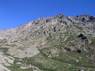
Route description:
From the trailhead, follow the dirt road a short distance, then take
the trail that cuts uphill in the direction of
Capu di Manganu (1631m). The trail will sometimes have signs saying "refuge".
The trail avoids all the zig-zags of the dirt road, merging back with the road only
at its final section where it contours around the hill and climbs on the north side
to the 4WD trailhead at elevation 1600 meter.
From Berg de Petra Pinzuta, the trail heads uphill to gain the lower part of the ridge
coming down from Capu di Villa (2184m). Do not ascend the ridge, but descend on the north
side. The route crosses a couple of creeks before reaching the refuge Erco (1667m).
From the refuge, there are two possible routes to the summit of Monte Cinto.
We ascended via lake Cinto, then made a direct descent, however, the two routes will be
described from the refuge to the summit.
Lake Cinto route:
Continue from the refuge up the valley on a well marked trail. The trail
has a fairly distinct section where it ascends on rock. Under dry conditions the friction
is excellent and one can walk up on smooth sloping rock in most places. There are several
variants here all marked by cairns that various people has left behind. The difficulty
of the easiest route under dry conditions does not exceed YDS 3, however one can easily
end up in more difficult terrain. Higher up, the trail follows a more well determined path crossing
loose scree and boulders. The lake is higher up than most people would guess, it is realistic
to estimate between 1.5 and 2 hours from the refuge
and up here to this small and isolated lake (elevation 2290 m, N42:22.268, E008:56.106).
From the lake, proceed up a large boulderfield that starts out towards the northeast then curves
a bit left (north) to the horizon ridge to the left of a pretty pronounced small peak on
the horizon, Punte des Eboulis, 2607m. There are small cairns along the way, but very loose
rocks, the best line is likely on the left along some small cliffs.
Once you reach the main ridge, follow the trail as it runs right in the direction of Monte Cinto.
You will see the trail from the north side climb up and merge with the top ridge trail.
Soon, the main ridge turns more difficult and the cairns lead the way quite some way down
on the south side. The route now continues along the upper south side of the mountain until a point
more or less directly below the summit. From here, the route finally starts uphill and heads up
to the main summit of Monte Cinto.
One should note that the route merges with the direct route coming
up from the refuge Erco in the area where the final uphill section starts. The map indicates that
the two routes are separate all the way to the summit, but this is not correct.
The entire route is mainly YDS class 2 and 2+ with isolated (short) sections of YDS class 3
terrain. However, the terrain does quickly become more difficult if you leave the main
route. There are many cairns around, often more misleading than informative, many being
built by random tourists telling "I was in this interesting spot", but not necessarily providing
any help in locating the best route. Overall, route finding is still pretty easy.
Direct route:
From the refuge Erco, head directly across the small creek and to the ridge that is
coming down from Monte Cinto. The trail first follows this ridge upwards, then gradually
the terrain turns into a very broad field with some vegetation. As the trail continues with
zig-zags upwards, there is less vegatation and more scree and loose rocks. When you
approach an area with solid rock starting to appear, two gullies continue above you. The cairns
as well as the clear signs of heavy use (broken trail) head up into the leftmost gully and this
is indeed the correct way. However, a number of parties end up climbing the right gully and
soon face a narrow gully with a huge rock blocking access. What is worse, there are lots of
loose rocks just above that easily fall down and may hit any person trying the somewhat
difficult climb. If already up in this wrong gully, the best continuation is to climb up
into the rock face on your right. Good ledges will then lead you across and back into the
gully above the obstacle. This section is objectively quite safe, but with
considerable exposure. The wrong gully then lead through a small notch and merges back with the
leftmost gully that you should have taken in the first place.
The route continues up through a set of gullies, all with pretty loose rocks until it merges
with the routes coming from the north (as well as from lake Cinto), well below the summit.
The remaining part is altogether an easy scramble to the summit.
Comments:
I did this climb with my son Pål Jørgen, age 16.
We started from our hotel in Piana at 0515, drove a short distance up the dirt road to
elevation 1212 meter and started hiking from this point at 0715. We reached the refuge Erco
in 1:25 including a 15 minute rest along the trail, at 0840. Proceeding up the valley, we rested
at lake Cinto at 1000, then climbed the ridge and arrived at the summit 1140, a hiking time of
about 4.5 hours. We rested at the summit in beautiful weather for 40 minutes before descending
the more direct route down to refuge Erco. This descent took slightly less than 2 hours, the hike
back down to the car another hour, thus reaching the car at 1515, precisely 8 hours after our
departure. Another two hour drive brought us back to the hotel at 1715, 12 hours after our early
start.
The descent from Monte Cinto deserves a special note. First, we met a group coming up that warned
us about the route, "plus dangerous", "tres alpinist" etc. they asked about the route via lake Cinto,
it was evident that they did not (for any prize!) want to descend the same route. Ok, I had read that
if any difference, this route was supposed to be slightly easier, we continued descending as planned.
Considerably further down a gully, I noticed a girl shouting to me. It took some looking around to locate
her, she was standing between two rock pillars with a 25 meter vertical cliff below her. She asked if
we were descending from Monte Cinto. I replied that indeed we were, then asked if she would be able
to downclimb (on the opposite side) from where she was. She told me that she believed she could. I told
her to carefully find her way back down the same route as her ascent. We continued down and then noticed
that the girl was in a party of six that all had climbed up to this difficult point. They shouted to us that
the route went through a notch between us. As we met, I immediately realized that the person speaking
english was a Dane. We had a friendly chat, they were from Switzerland and Denmark. I told them how to
proceed and they warned us that the descent below involved a 5 meter vertical section with real
climbing difficulty. We split and Pål Jørgen and I continued down the gully that the other
party obviously had ascended. Further down, I immediately saw "the crux" that clearly had spooked
the parties coming up. The gully narrowed to about 1.5 meter, it was blocked by a big rock that had
gotten stuck. Above it were loose rocks that easily fell down, below it a 4 meter overhanging drop.
One could likely climb up, but climbing down would be difficult. Additionally, the loose rocks above
called for extreme caution. An accident waiting to happen if people stayed above and below at the
same time. I ascended back up, left the camera in the pack (with Pål), then decided to explore
an alternative traverse out to the left side, possibly this could circumvent the problem.
This route was airy, but technically much easier as well as safer. I called on Pål Jørgen
to follow, too bad he now had the camera since a picture in the wall would have looked good.
I told Pål Jørgen that this could not possibly be the correct route. Sure enough, shortly
below this gully merged with another gully coming down from our right. This gully looked totally trivial,
it had cairns as well as clear signs of a trail. How several teams ended up doing the difficult
(and dangerous) right gully is not easy to comprehend.
M5 continued the next day with Monte San Petrone.