Black Butte
- Black Butte
- 2270 m
- Primary factor 742 m
- Location: North 39:43.604, West 122:52.347 (GPS at the summit)
- Mendocino, California
- Difficulty: YDS class 1
- Climbed: October 23, 2011.
Black Butte
|
|
How to get there:
This mountain is in the Mendocino wilderness area. Drive north from San Francisco (first on I-80
and then on I-505) on I-5 to Willows (exit 162). From here, go west on US 162
for about 20 miles towards Elk Creek. The road crosses a river and Elk Creek is about a mile going
left (south). You should turn right here and go north 3.7 miles, still on Hwy. 162.
At this point a road forks left (west) at a 90 degree angle. Take this road, initially Hwy. 162, but
soon to be called FH7. Follow this road exactly 32 miles from this left turn, the first 6.9 miles are
paved followed by a very good dirt road for the remainder of the distance.
You are now at location N39:44.567, W122:52.008, elevation about 2045 meter, where a smaller road
forks left towards Black Butte. Drive this road as far as you feel comfortable. After an initial
uphill, this road reaches a flat area in a shallow saddle where it is ok to park. The road does continue
more steeply uphill and gets quite a bit rougher near its end. I parked at location
N39:43.845, W122:52.259, elevation about 2113 meter, near the end of the road.
An alternative approach, if coming from Yolla Bolly, is to drive forest road M2 south
and locate the forest road intersection named Mendocino Pass. From here, continue south along forest road FH7 for
6.5 miles and locate the turnoff described above.
Route description:
Follow the road uphill until it turns into a trail. This trail continues up the slope making
a few zig-zags before attaining the very summit of Black Butte. Allow perhaps 15 minutes
(each way) for the hike.
Comments:
I had been climbing Yolla Bolly Mountain in the morning and was now
looking for Black Butte. I had returned to Paskenta, then driven a bit south before the
road took me back up into the Mendocino Wilderness area. None of the (many) roads up here were
on my Califonia road map. However, I had a vague idea about which direction to drive.
Things got more complex as the main forest road was closed and a detour pointed left. As is often
the case with detours, there were no more sign at subsequent road forks indicating how to get
back to the road I had left. Eventually, I arrived at an intersection on a ridge and spotted another
car there. I stopped and asked if they knew the area. Afirmative. Do you have a map? Afirmative
again. I had a close look at their map, when the one guy said I could have it. I was very happy
about this, but insisted to pay him 10 dollars. This map should turn out to be absolutely invaluable.
I continued to Mendecino Pass, then along FH7 to the sideroad serving Black Butte. This road got
steep and rough near its end and I parked, also in order to get a small hike to the summit.
The road changed into a nice trail only slightly higher up and a short walk brought me to the summit.
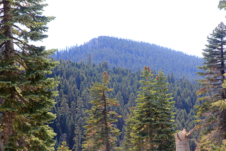
Pretty good views, but the day was already well on its way to end.
I decided to make a plan for tomorrow. My truck was drinking gas by the gallons. I decided to return
to Willows on I-5, have dinner, then try to locate the trailhead for Snow Mountain. In this way, I should
have enough gas to continue driving across west to Hwy. 101, possibly picking up a few more P600
mountains along the way. Consequently, I drove FH7 further east towards US 162. Before hitting
this highway, my left front tire suddenly broke completely and turned flat. Bad news! I immediately
started the process of putting on the spare tire. This tire was located UNDER the car and attached via
a mechanism that certainly turned out to be the crux of the entire operation. Changing the tire
was easy in comparison. I continued to Willows and had a nice Mexican dinner there.
After dinner, I drove south on I-5 to Maxwell, then towards Snow Mountain.
Here is a map with an overview of all my travel in Mendocino on this trip.