Location: North 47:19.602, East 010:07.687 (GPS on the summit)
Difficulty: YDS class 1
Climbed May 4, 2010.
Information:
How to get there:
Locate Oberstdorf in south-west Germany. Travel south through
Oberstdorf towards Kleinwalsertal, a small, isolated piece of
Austria. You will enter the village of Riezlern, continue through
this village. Just as you leave the village, pay attention as you
cross the main river on a bridge. Just across this bridge, make a right
turn onto Schwarzwasserstrasse. Follow Schwarzwasserstrasse up the hill, as you
arrive at a flat area, take the road that forks left, the name is Schoentalweg.
Continue uphill to the next flat area where there is space for parking. This is
a good trailhead, the location is near N47:20.798, E010:09.572, elevation a bit
higher than 1300 meter. (The coordinates given are for
Soellerhaus, Schoentalweg 10, the place I was staying, the parking is slightly higher
up along the Schoentalweg.)
Route description:
Continue uphill along the small, paved road. When you arrive at a 4-way intersection,
take the left fork that descends slightly. There is a sign here, Panoramaweg and
Walmendingerhorn are both correct. After a short while you arrive at the first
restaurant along this way, the Sonnalp. Continue to the next restaurant, called the
Bühlalpe located at 1435 meter. From here, the route is more uphill. Fork right
onto a trail (leave the road) higher up and follow this trail until you reach a new
trail fork just below the main ridge. Turn right and climb the last hill to the restaurant
that is located just below the summit. This restaurant is also served by a gondola lift
from the valley floor. The final 3-4 short zig-zags of the trail will get you to the
summit and its large summit cross.
There are two alternative and shorter routes. There is a trail on the north side of the
main ridge passing through the place Untere Walmendigeralpe (1424m), and a more advanced
route that follows the very top of the NE ridge extending from Walmendingerhorn.
See the comments below.
Comments:
I was attending an international workshop (nicknamed DD 19.5) at the Soellerhaus, a nice
place that hosts small conferences. On Friday aftenoon, the program called for a hike
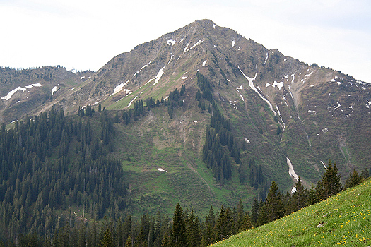
to the local summit Walmendinger Horn, 1990 meter.
We started from Soellerhaus after lunch around 1345. A big group, but it was clear that some
would be happy reaching a restaurant along the Panorama Weg. We all had a good time, speeding
up a bit as the hill got steeper (and the group smaller). We were on the summit shortly before
1530, a vey good view and everybody had a good time. We descended back down to the
restaurant and enjoyed some cold drinks before thinking about the return trip.
We left the summit restaurant at 1630, hiked down to the first curve and took a trail that
forked left. Descending, we crossed a small snowfield, then accessed the beginning of the
north-east ridge. The main trail back towards Soellerhaus traverses well below the ridge (on the
north side), a smaller trail continues on the very top ridge. There is a prominent sign at this
fork advising that "climbing gear" is required in order to follow the top ridge. The sign explicitly
says that hikers should not attempt this route.
The ridge had looked interesting from the summit and Christoph Augustin (a PhD student in Graz)
and I decided to give it a try, agreeing that
we could turn back if it became too technical. The rest of the group continued on the main trail.
The ridge turned out to be very nice and entertaining. Quite a bit of air, but no big difficulties.
There were two sections of slightly exposed downclimbing. Care is needed and this route is likely
not nice if wet and slippery. A few loose rocks, but generally quite good footing. The ridge is somewhat
easier to traverse in the opposite direction. Overall, the difficulty is mostly (YDS) class 2+, with a couple
of (YDS) class 3 moves. The terrain is steep and one should not attempt this route if one is
uncomfortable with exposure.