Location: North 39.47290, East 020.54736 (GPS at the summit).
Difficulty: YDS class 1.
Climbed October 14. 2021.
Information:
How to get there:
The access to this mountain is quite good from the Motorway (4 lane road) called A-2.
Drive west from Ioannina or east from the coastal town of Ladochori. Exit in order to access
location N39.49666, E020.53703, elevation about 650 meter. Continue uphill (several turns) to
location N39.49402, E020.53799, elevation near 700 meter. A dirt road starts here, going right.
A high clearance vehicle may continue up this road to location N39.48647, E020.54589, elevation
near 1035 meter. This is a sharp right curve with good parking on the left side. This is
a good trailhead. This dirt road is a bit more than 3 kilometer, it is perfectly fine to start
the hike from near the beginning of the road.
Route description:
Continue along the road to location 39.48345, E020.54049, elevation near 1100 meter. Here a very rough
track (from some forest work?) runs uphill. The route is also marked with red and white colored ribons
as well as some red paint. The trail itself is not extremely easy to see everywhere, but overall it
should be easy to follow the route. It eventually breaks out of the forest and continues a short
stretch across more open terrain to a small local col. Continue downhill about 50 meter, attention is needed
here as the trail is hard to see. (I lost the trail here!). Do not descend any further, but traverse right
and follow an open passage that soon will start a gradual climb. Some trail markers may be seen, more as
you get higher. Continue to follow an open passage that will ascend along the ridge, staying north (left) of
the highest terrain. You will pass a small (lower) summit located on your right, then ascend to the (highest) summit from
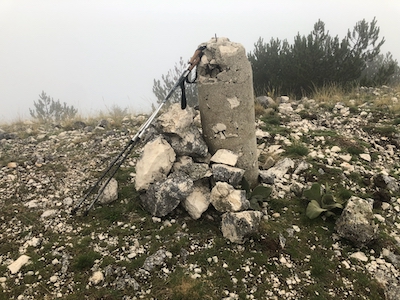
near the small col between these 2 summits. There is a concrete marker on the top.
Comments:
Todays forecast promised rain, a lot that is. We even received text-messages from the Greek authorities
advicing people to stay indoors if at all possible. It rained while I drove west to the mountain.
Fortunately, it stopped as I stepped out of my car at the trailhead. No rain until after my return,
but grey and misty with very limited visibility.
I started at 1015, the trail was well marked with ribons and red paint. Still, there was a single critical
section just after the small col, where the marking led me too far downhill. I bushwacked back up
and recovered the marked trail before the last stretch up the ridge to the two summits (I visited both). I certainly
wasted some time, but still arrived at the summit in 1:25. A brief stop, but with no visibility, I
started down after 5 minutes. The return hike took 50 minutes, the rain had made everything quite slippery.