Location: North 59:51.258, East 008:38.953 (GPS on the summit)
Near Rjukan in Telemark
Climbed June 19. 2004.
Information:
How to get there:
The standard access from Oslo is to drive E-18 to Drammen, then continue
along E-134 through the cities of Kongsberg and Notodden. Approximately
20 kilometer after Notodden is the small community Sauland, make a right there
up Tuddalsdalen towards Rjukan (the last part of this road is
closed in winter). Continue across the highest point on this road and until
west of lake 1138. The road has a short unpaved section with parking on the right hand
side and the Gaustatoppen trailhead on the left side.
The trailhead is located at GPS location north 59:50.062,
east 008:42.829, with elevation 1180 meter. Route description:
From the very obvious trailhead across the road from the parking,
pass through the gate and follow the trail (marked with red T-s as well
as cairns). The trail first goes through a small saddle, then ascends across
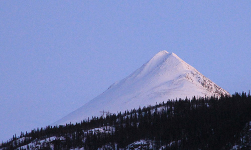
a fairly large slope. Higher up, a cross (old grave) is on the left side of
the trail. At around 1550 meter of elevation the trail levels off and actually
descends a bit before hooking up with the proper ridge of Gaustatoppen. From here
on, the trail is well marked as it climbs the higher part of the mountain in
several zig-zag moves. Eventually, a couple of huts will come into view, a bit higher
one also sees a tower shaped structure. The summit is not here, another 500 meter
of ridge needs to be traversed. Until here, the difficulty of this trail is (YDS) class 1,
however, the ridge is class 2+. (When I was there, the difficulty was more like class 3
due to a thin layer of hard ice covered by new snow.) This ridge is quite distinct,
but never very narrow. Huge boulders make for easy scrambling unless you have
adverse conditions. Comments:
I started from the trailhead at 0800, light snowshowers and fog, but
the visibility was perhaps 100 meter. It did strike my mind that a map
would have been useful, but this trip came about with no time to buy one.
I do have most of the maps I need in Southern Norway, but this one was missing.
Anyway, the trail was big and well marked, I was climbing a mountain, so it should really
be a matter of heading uphill. The new snow on the ground got deeper, and after passing a
cross clearly marking a grave, the trail became level and subsequently vanished. No more
T-marks on any rocks, no cairns and not a trace of a trail. With visibility down to 10 meter
in the fog and all this new snow, this was hardly a surprise. Activate the well known
algorithm: Just continue uphill. Uphill was slightly left, I ascended to about 1600 meter and
to my surprise, entered a very flat area full of slippery rocks. Within my visibility, my
algorithm failed miserably! After wasting about 30 minutes searching around for higher ground,
I returned to the spot where I last saw a cairn. The only sensible approach now was to continue
without gaining elevation. (It later turned out that the trail actually descends a bit in this
area. This trouble spot was at elevation 1555 meter, north 59:50.631, east 008:40.408.)
This was indeed a better algorithm and fairly soon I noticed some old wooden poles and then a
cairn followed by more signs of a trail. From here on the trail was very well marked with red T-paint, as
well as cairns. I finally made the huts near the summit
around 1045, almost 3 hours. The ridge to the summit was covered
by thin "blue ice" under 10-20 cm of new snow, a most unpleasant combination. It took me 25 minutes
and great care to traverse to the summit. The clouds broke for about 30 seconds while on this top
ridge, I then spent about 10 minutes at the top that is known for its excellent views, no such thing today.
Another 25 minutes to get back to the huts, then one hour to the car. When I came to the place where
I was temporarily lost, my footsteps seemed incredibly numerous. The explanation came as I overtook
several parties (about 10 people) that all had followed my footsteps, gotten totally confused in the
maze and then given up their hike altogether. I felt a bit sorry for them, however each party must
navigate themselves, not just follow (possibly confused) footsteps.
Resources:
Images
Gaustatoppen, as seen from the air on March 31, 2004.
The tower and the long ridge can be seen.
Gaustatoppen as seen from Gøysen (1370m), April 9, 2005.