Svalbard Trip Report, April 21, 2013 - May 5, 2013.
Copyright Petter Bjørstad, 2012-2014, photos by Arnt Flatmo and Helge Larsen.
Before the Trip, Preparations.
I had been thinking about organizing a ski expedition to Svalbard for a few years.
In particular, I knew that my friend Geir Åke Dahlen, really wanted me to announce such a trip.
Thus, with no big trip planned for the spring of 2013, the idea returned to my mind on November 24th.
2012. I quickly decided that the trip needed to go at the very end of April and that I wanted
a team of minimum 4 people. The trip should first and foremost be a ski trip, while the two mountains,
Newtontoppen and Perriertoppen, would serve to determine a suitable route.
A very brief history of Svalbard
The name Svalbard means (old Norse) "The country with the cold coasts".
Svalbard is defined to be all islands between 74 and 81 degree north and between
10 and 35 degree east. The total area is slightly more than 61.000 square kilometer.
The biggest island is Spitsbergen, a bit more than half the total area. The islands are
located in the north-west of the Europe-Asia tectonic plate, that is, there is shallow water
connecting to the south and east, while the sea is deep to the north and west.
Svalbard was first mentioned in old viking writings dating back to 1194.
The Dutch explorer Willem Barents visited in 1596 and already in 1615 were naval vessels
from Denmark-Norway in the area to protects its rights and ownership.
In more modern times, Norway was assigned the ownership of Svalbard via the Svalbard treaty
signed in Paris on February 9th. 1920. This treaty guarantees certain rights to any person from
a country that has signed the treaty, ie. the right to travel to and conduct business in Svalbard.
Norway subsequently enacted a law on July 17th. 1925 that follows up on the treaty and states that
Svalbard is an integral part of the Kingdom of Norway.
This history has some implications that a visitor today will notice. There is no VAT at Svalbard,
Svalbard is outside of the Schengen passport area. Norwegians may travel between Norway and Svalbard
with a valid (pictured) Bank Id or drivers license, whereas all other nationalities must present their
passport when travelling to Svalbard.
Traditionally, the coal mining industry dominated in Svalbard. Today, the tourist traffic as well as
scientific studies including a university center for arctic studies, are also important. Longyearbyen
has more than 2000 inhabitants, The only other locations with more than a few buildings are Barentsburg
(Russian coal mine, about 500 inhabitants), Ny Ålesund, a research station with from 30 people
(winter) to 130 people (summer). The Svea coal mine has about 200 workers who live there during their
1-2 week work periods, however nobody lives there permanently.
Svalbard has a modern ghost city - Pyramiden at Billefjorden. This city
had more than 1000 (Russian) inhabitants, but everybody left at the end of 1998.
Newtontoppen and Perriertoppen - which one is the Svalbard HP?
We have listed these two summits with one meter difference in height. Actually, most sources
state that Newtontoppen is the higher peak, however this issue is not completely resolved as will
be clear from the information given below. There has been only one official survey of these two
summits and the report from this survey reads as follows:
In the period from May 6th. to May 12th. 1996, an official expedition was carried out by the
Norwegian Polar Institute. This institute is the mapping authority for Svalbard. The purpose
of this trip was to determine, with high accuracy, the elevation of Newtontoppen and Perriertoppen.
The team consisted of 4 members. Among the team members were Bjørn Lytskjold, topographer and
Tron Eriksen, geodet. As the accuracy of previous measurements had been questioned, a key purpose of
this trip was to carry out precision measurements.
Thus, the expedition brought along top of the line GPS equipment, 3 double-frequency Aschtech receivers.
One receiver was placed at a known location, while the two other receivers were placed at the highest
point of the two summits in question. Next, one let these units collect data over an extended period of time.
After a careful analysis of the collected data, the following result was obtained:
Newtontoppen: 1713.25 meter
Perriertoppen: 1712.35 meter
The GPS measurements had an accuracy of 1-3 centimeter when the measurements are made relative to
the WGS84 ellipsoid. However, when adjusting this to the elevation above sea level, additional
uncertainty/inaccuracy is introduced. The accurate transfer of the data from the ellipsoid to the
geoid (sea-level) depends on gravity data, sea-level measurements etc. There is currently limited data
available and to obtain the required data in the Svalbard area is exceptionally demanding. Thus, the
accuracy relative to sea-level is in the range 20-30 centimeter.
In conclusion: At the time of measurement the Newtontoppen was approximately 90 centimeter higher
than Perriertoppen. No newer measurements exist, so this is the most current survey of the two
mountains. However, both measurements were done on the highest snow on the two summits at the time
of measurement. Both summits are covered by a thick layer of snow, no attempts were made to
measure the thickness of the snow/ice down to solid rock. It may be assumed that the snow/ice
has melted somewhat since 1996, implying that the summits may be a bit lower today.
Obviously, changing snow cover from year to year, even from week to week, may easily be the single
biggest source of error / uncertainty. With this knowledge it seems that one really should attempt to
visit both peaks in order to be absolutely certain that the Svalbard HP (and ultra) has been climbed.
Regulations:
When planning a trip to Svalbard, there are several steps one must be aware of. There are several
guide services that operate commercial (ie. tours that are preplanned and where one or more guides
will be part of the group.) tours. Unless one has substantial wilderness experience, such a tour may
be both best and most convenient.
If you want to organize a private trip, then the first thing to decide about is if the trip can be
restricted to what is called Management Area 10 or not. (Norwegian: Forvaltningsområde 10). Newtontoppen is
located in Management Area 7, that is, outside of Area 10. Trips within Area 10 does not require any much paperwork,
while trips outside of Area 10 do. Here is a map of Svalbard that
shows the division into the different management areas. One will notice that Newtontoppen and Perriertoppen both
are located in Management Area 7.
If you plan to visit an area outside of 10, then a notice to the Sysselmannen (Governor) must be filed.
Unfortunately, the required form for this purpose is not (2013) on the internet, it must be requested by
contacting the Sysselmannen office. I sent an email requesting this form and for a while nothing happened.
As it turns out, Sysselmannen will reply within a month, the incoming email/requests are processed in the
order they are received. A much better approach is therefore to call the Sysselmannen office and request
this form, possibly after sending the request by email. In this way, you may reduce the processing time by
3 weeks or so. Here is a picture of this form that must be used to give notice.
This form contains several questions, among others questions related to protection against polar bear attacks
and questions related to means of communication, in particular emergency communication. Sysselmannen demands
that any party travelling outside area 10 carries an emergency beacon. It is furthermore strongly recommended
that one carries a satelite phone. In order to get these items under control, most parties will rent such
equipment from Ingeniør G. Paulsen.
As soon as you have everything that
needs to go on the Sysselmannen form, you should send it (by email) to the
contact person that you hopefully has talked to at the Sysselmannen office.
What remains is the application form
for renting a rifle to be used for polar bear protection.
This is not needed if you are a licensed hunter of large animals in Norway, ie. you have the "Jegerprøven"
certificate.
Based on your filed notice to Sysselmannen about your planned trip, his office will decide upon a
monetary liability for the expedition in case a search and rescue effort is initiated. This sum must be
guaranteed available to the Sysselmannen office, either
in the form of a SAR insurance document or as in the form of a
bank guarantee. In our case, this liability was set at NOK 100.000.
When all of the above have been taken care of, what remains can be taken care of in a half
weekday in Longyearbyen. You need to check by the Sysselmannen office and receive a yellow card
that must be carried along on your trip. This card shall be delivered at the Sysselmannen office
upon completion of your trip. Also, you need to check by Paulsen and collect the various items
that you have agreed to buy/rent from him.
Clothing, Boots and Climbing Gear:
This is a trip far north in arctic environment. The forecast had predicted temperatures
in the range from -20 to -30 Centigrade. However, due to more precipitation than normal,
we experienced milder temperatures, typically around -10 Centigrade.
Standard winter clothing for a trip like this consist of an inner layer of wool, say from
the line Devold Arctic, then a layer of fleece and a wind proof goretex outer shell.
Additionally, down parkas for camp use and a single pair of down pants to be used on polar
bear watch during the night.
Boots caused a bit of concern as most of us did not have good boots for extensive cross
country skiing (in cold temperatures) that would also be comfortable for steeper snow slopes
were crampons are needed. Thus, we allowed the luxury of an extra pair of leight-weight
climbing boots to be carried on the sleds.
We had limited and partly conflicting information about the steepness of the Perriertoppen
mountain. Since we were travelling across glaciers on most of the trip and since these glaciers
do have crevasses, typically covered by a safe layer of snow in April/May, we needed to take
along some protection anyhow. We brought along harness/prussik individually, then a 60 meter
half-rope, 4 deadman snow anchors and 3 ice screws, 2 jumars as well as carabiners etc.
Each team member had craampons and an ice axe, while Helge carried his two climbing axes.
Food and Cooking:
We largely went with Drytech (Real) freeze dried dinners, a quantity of 48 orderd
from G. Paulsen in Longyearbyen. Breakfast consisted of warm instant oatmeal (soup consistency, due
to more water), mixed with brown sugar, hazel nuts and raisins. Helge ran a separate
regime based on bread since earlier trips had shown his incompatibility with this kind
of breakfast. For lunch, we just carried chocolate bars. Additionally, we carried a small
amount of cheese and sausage to be served as an extra snack in the tent after dinner.
The planned diet would not fully replenish calories burnt. In fact, the assumption
would be that we each would loose (burn) about 5 kg of body weight during the trip.
Cooking was planned to be based on two sets of gasoline burning primus. We had ordered
15 liter of "clean" gasoline (white gas) from Paulsen. The idea was that each tent would
do its own cooking. However, by an oversight, one of the participants forgot to
bring the cooking pots (and in particular the handle!) assigned. This should ideally
have been discovered in Longyearbyen, with time to replace the missing set, but was not.
Thus, we ended up with a single pot for melting water. The consequence was somewhat longer
time spent on melting/boiling water each evening, but also most likely a saving in the
gasoline needed. Our actual use was only about 0.6-0.7 liter per day.
Note: Some Additional text and many photos by Arnt Flatmo and Helge Larsen will be posted quite soon.
Day 0, April 21st. We fly from Bergen.
Helge and I met at Flesland airport around 1630, with ample time to check in our
bulky luggage. Helge and I had met 2 days earlier to pack our 3 sleds and the two
VE-25 expedition tents into a single piece of cargo. A bulky ski bag similarly
contained our skis, some poles and a few pieces of climbing gear.
While Helge took care of the
hand luggage, I went to the check-in counter and had a pleaant conversation with the
SAS representative. She agreed that all 4 items should be sent as special luggage
and that we really did not need to check any weight since I told her that nothing
was exessively heavy. Thus, we boarded our plane for Oslo where we would meet Åke
and Arnt and find the direct flight to Longyearbyen, Svalbard.
This flight left from the far end of the international departure area, since Svalbard
is outside of the Schengen area. I guess this is about the only flight one may take
from Oslo Airport, passing through the passport control with only a drivers license as
your travel document.
Our flight arrived on time in
Longyearbyen, shortly before midnight. Full daylight,
we had actually seen a sunrise on the flight going north. The airport bus (NOK 60),
took us to Svalbard hotel/lodge were we had secured a 4 bed apartment for the night.
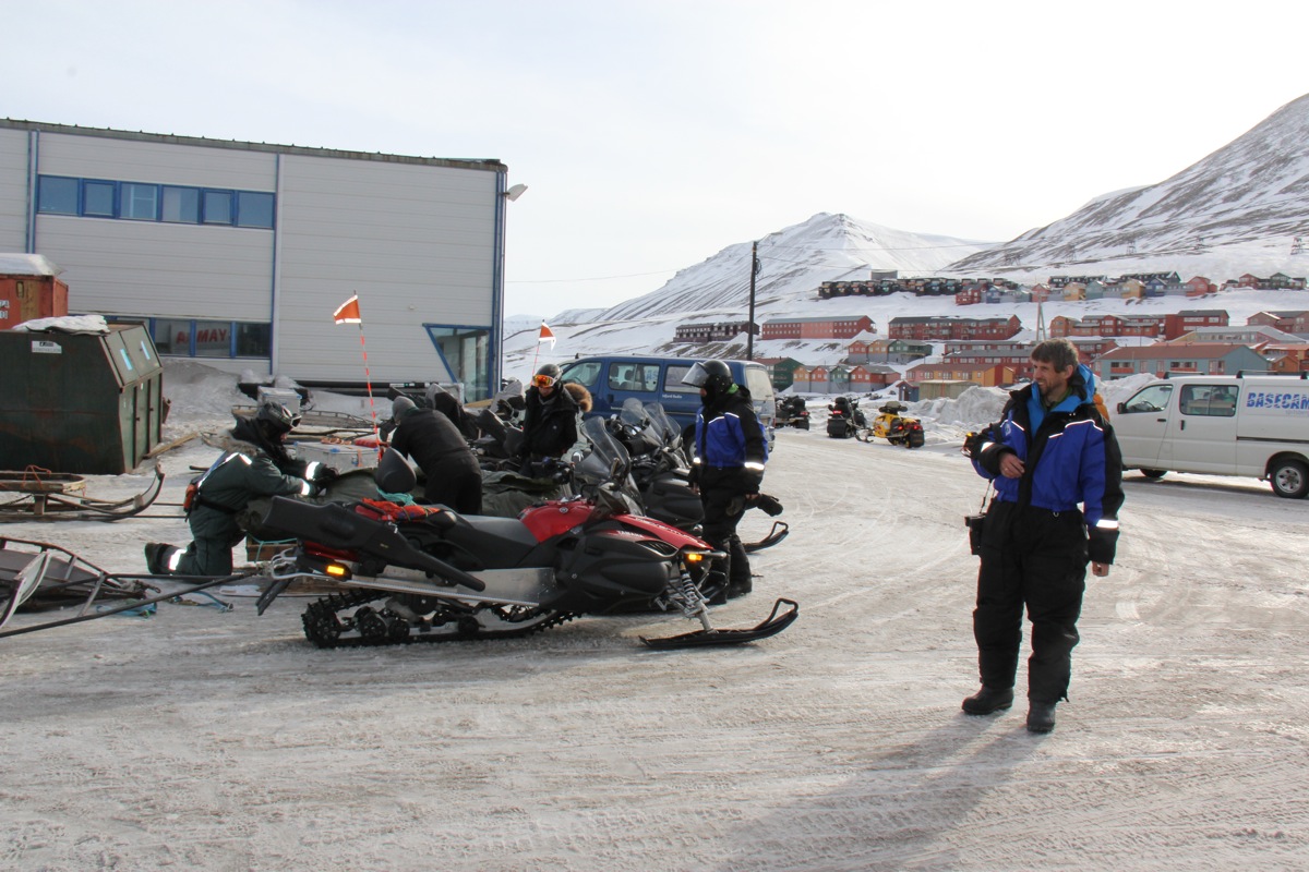
Day 1, April 22nd. Logistics, Scooter transport and the first day of skiing.
We had agreed to depart by snow scooter from Paulsen around 1300. The morning was
busy getting organized.
All gear should now move from bags to the sleds. Additionally,
I needed to pay a vist to the Sysselmannen office, in order to pick up the yellow
(permit) card to be carried along on the trip. Similarly, I visited Paulsen
and checked out the rifle (an old well proven Mauser 30-06), as well as the satelite
phone, signal pistol etc. I bought 20 additional shots for the weapon to be used for
practice. In parallel, the three other team members went to the grocery store and
secured additional food for the expedition. This all went smoothly according to plan.
Around 1300, we all assembled outside Paulsen
and were given full body dresses for
snow scooter transport as well as boots and helmets. The backpacks and sleds were
loaded onto bigger sleds and we were soon ready to leave with each man sitting behind
the driver on 4 snow scooters.
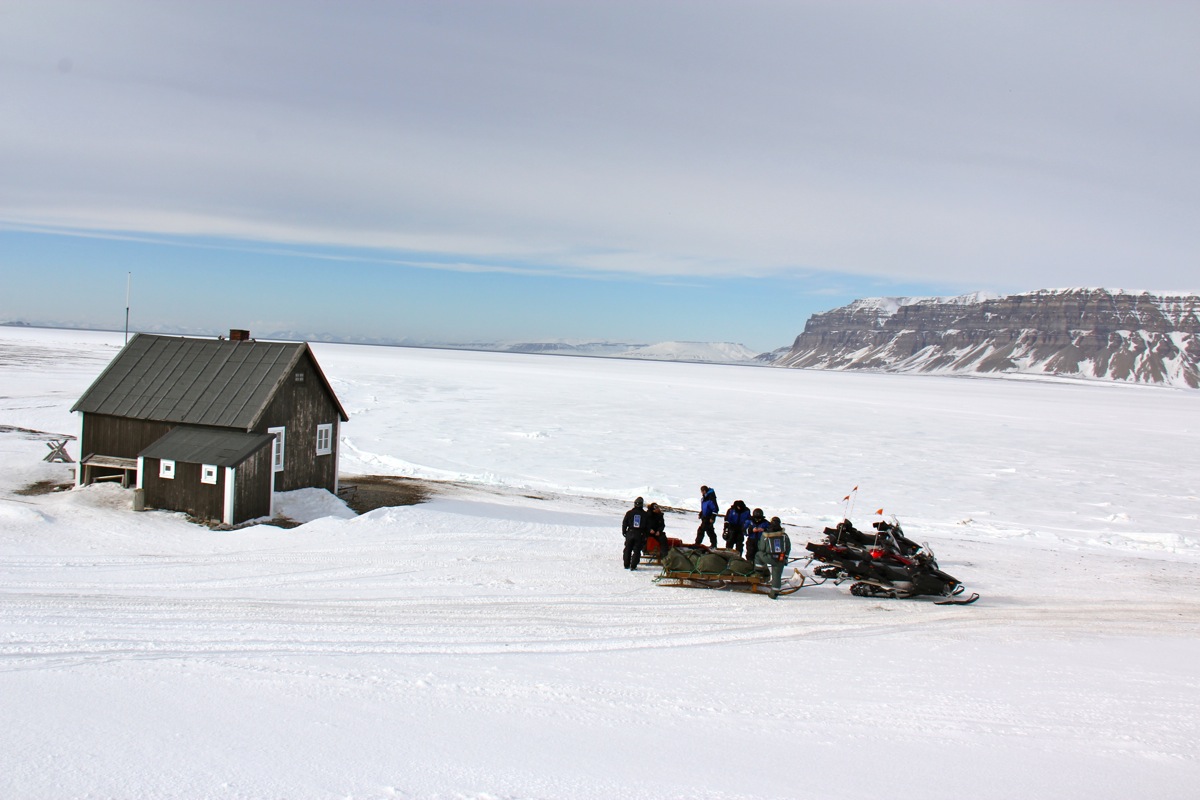
The route driven went up Adventdalen, across through Eskerdalen, then down Sassendalen to
the old trapper hut called Fredheim where
we had a first short rest.
We continued across Tempelfjorden to the delta of the Murdochelva river, then up
the Fuhrmeisterdalen valley and the Burn Murdoch glacier, crossing the col and descending
along the Bolton glacier to the big Gipsdalen valley. North-east up Gipsdalen to the saddle
between Urmstonfjellet (1116m) and Minkinfjellet (1018m). Here, we had a second good rest
before the final leg of our scooter transport. We descended the Nordenskjöld glacier to
the Adolfbukta, then on the sea ice turning Rudmosepynten into Petuniabukten, the innermost
part of Billefjorden.
Upon reaching the shore, our transport was completed.
We were at sea level,
not very far from the ghost city Pyramiden, but in a good location to start our ski expedition.
Our transport left after
taking a team picture for Facebook. It turned out that one of our
drivers knew Anne Rudsengen, Arnt's partner. He promised to post it. We were now on our own.
After a short break to get things organized,
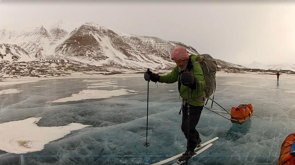
we skied towards Ragnardalen. In Ragnardalen, just before
reaching the glacier, we crossed a pretty big lake. This crossing was interesting, since there
was no snow on the ice
and the ice was transparent like a window!
We could study the ice structure,
the variable thickness and also see clearly the details at the bottom of the lake. Quite exceptional,
I have never seen anything like this before.
The glacier had a nice and gentle slope and we made steady progress towards the top. The weather was
overcast, but with high clouds and good visibility.
We were quite happy when setting up camp at the
highest point of the col just north of Luxorfjellet (680m). From here, we had a great view towards
Austfjorden to the north. Todays effort was about 8 km of skiing with a vertical gain of 470 meter,
establishing Camp I.
Day 2, April 23rd. We continue gentle uphill skiing.
The morning weather was similar to yesterday, overcast, but with pretty good visibility. After
breakfast, I organized a session of shooting practice.
First, we fired at an empty Drytec bag at
30 meter range. All 4 of us hit this target. Next another target was put up only about 12 meter away
and a bit to the left of the original. The test was now to first shoot at the 30 meter target, then
quickly (2 seconds) reload the rifle and fire a second shot at the closer target. A few misses at the first target,
but all hit the closer one. Helge was judged having the best results and named official polar bear
hunter if such a (critical) situation should arise with an option to designate a shooter.
We proceeded to ski gently uphill and intended to cross the Mittag-Leffler glacier and ascend the
Conwayjøkulen. However, we gained a bit too much elevation and decided to rather ski towards
Sedgwickjøkulen, then west of Oberonhamaren (1005m). Time was running and our progress was not
impressive, having fairly heavy sleds and a continuous, gentle uphill.
The team was pretty tired when we decided to
set up Camp II at 920 meter, a bit northwest
of Oberonhamaren, similarly southwest
of Uranusfjellet (1135m). We had skied about 15.5 km and
gained another 460 vertical meter.
The weather gradually turned more foggy and
we lost general visibility as we turned into tents and sleeping bags except for the
man staying outside on polar bear watch.
Day 3, April 24th. Bad weather, short ski to depot.
The weather got worse during the night with more wind, snow drifts and generally white-out conditions.
Helge came into the tent in the morning (after 2 hours of polar bear watch)
and declared that "we had skied under worse conditions."
Accordingly, we broke camp and continued towards the broad col east of Sentralishetta (1265m).
The weather did not improve and the time was already 1530 when reaching the col. We established
a cache here (Our depot), consisting of 3-4 days of food supplies plus 5 liter of gasoline. Our plan
was to pass this point on our return trip and save the effort of hauling this weight around our
northern loop. After preparing the cache, we decided that
we might as well set up Camp III and
hope for better weather the next day. Todays effort was limited to 8 km and 260 more meter of
vertical gain, as we now camped nearly 1200 meter above sea level.
Day 4, April 25th. We ski to the base of Newtontoppen.
The wind subsided, but the fog remained.
We started out with no visibility towards northwest, crossing through the very nice and gentle
col between Titanfjellet (north) and Tethysfjellet (1380m, south). As we continued north-east, we had
our first section of gentle downhill - it felt just as nice as expected. Skiing on the Kepler glacier
we got below the worst fog and caught sight of Astronomfjellet (1343m). Pretty nice to ski on eye-sight, this is
much better than going only with the GPS. We also noticed Håpfjellet (1260m), as we headed towards
Kvitbreen. It had snowed quite substantially and we made a pretty deep track while pulling the sleds along.
Soon, we were back in white-out conditions as we crossed north-east towards Ermakbreen.
Turning gradually more north, we were now approaching
the 79th. degree north parallel.
The crossing was
properly celebrated with a small piece of chocolate.
As we continued, the clouds started to break and we had a very nice landscape unfolding below and behind us.
We needed this nice evening in order to stay motivated and pull our sleds up the gentle hill until we reached
an elevation of 1300 meter. A good job
today and time to set up camp IV. The stats. were reading
15 kilometer and about 350 meter of ascent. By now, it was pretty obvious that, due to the lack of
visibility, the deep snow to push through, but more significantly, the fact that we needed to do the
2-hour polar bear watch among only 4 men, a 20 kilometer day should be about all we could really do.
We were now in a very good location for ascending Newtontoppen, the official highpoint of the Spitsbergen
island as well as all of Svalbard.
Day 5, April 26th. We climb Newtontoppen and ski to the top of the Gallerbreen glacier.
Yesterday ended brilliantly and today was summit day for Newtontoppen. Unfortunately, the fog
had returned and we had no visibility as we broke camp. We continued our climb to reach the 1400 meter
contour level. At this point, we left the sleds and two backpacks behind before setting out to find
Newtontoppen somewhere above us on our left hand side. We skied on GPS until just below the 1650 meter
contour, from there on I preferred to navigate using my map and a compass. We knew that we were approaching
the summit essentially from the south, staying a bit east of this line. The summit has a steep north facing
slope that we should pay attention to. This strategy worked well
and we could ski the last few meter to the summit
about one hour after leaving the sleds.
Unfortunately, we had very limited visibility - nothing could be seen except for the local contours of
the summit. A bonus was mobile phone coverage, Arnt and Helge took the opportunity to call their
loved ones.
We left after about 15 minutes and quickly skied back down to our sleds.
The day was not over, indeed today became our longest and most accomplished day of skiing.
We first crossed down the somewhat steeper slopes between Newtontoppen and Makarovtoppen (1540m) on our
right (north) side. This hill was steep enough to cause our sleds to roll over, the single man without
a sled suddenly became indispensable.
We continued gently downhill while going north on the Chydenius glacier, then turning left around
Clairauttoppen (1632m), before heading more west to the col above Kingbreen. Here, we saw traces of
a recent campsite. Kingbreen was quite a nice downhill and soon our team was well onto the
large glacier that runs north, named Veteranen. The idea had been to camp here, however, I realized that
this would be a bit suboptimal, provided that our next camp should be at the top end of the Galler glacier.
Helge broke the silence by asking: "The time is only 1800, why should we not be able to ski until 2100?"
Everyone agreed that we could go on for another 3 hours. Then, about halway across Veteranen, we noticed a
solid track that headed our way. We followed this and entered a new uphill on Gallerbreen.
Again, in order to lift the general spirit, the clouds started breaking and good weather and visibility
returned. It was a beautiful evening and this powered us up the last few kilometer of hill, still in the
good track that seemed quite new. We established Camp V precisely on the col between Gallerbreen and
Tryggvebreen, a good location for an attempt on Perriertoppen.
Not only did we climb Newtontoppen, a 300 meter vertical ascent, we also
moved about 25 kilometer and ascended
another 400 vertical meter - quite a good day.
Day 6, April 27th. We climb Perriertoppen.
Hoping for continued nice weather, but getting a repeat of previous patterns. Yesterday ended beautifully,
this morning came with fog and white-out. We had a brief discussion, should we still ski towards
Perriertoppen? My view was that there was little to loose in trying today. Perhaps the afternoon/evening would
repeat the two previous days and clear? We decided to take one sled with climbing gear and light backpacks for
a day of skiing in a remote, arctic environment.
The first slope was supposed to be steepish, however, with good snow it was very skiable. We descended in
the fog and started on a GPS course across to the north branch of Tryggvebreen, the one providing access
to Perriertoppen. We tried to stay a bit right in order to stay as high as possible, this turned out to be a
mistake. As we traversed, the fog started to lift. We first noticed two tents further below us on our
left side, then a party of 4 skiers on their way from Perrier and back to the camp. They also had a couple
of dogs. Since we had a late start, we assumed that they had started early and now returned from climbing
Perriertoppen. Good news, the weather was about to turn really nice and we might even have steps all the
way up?
We skied up the slope to the key col, quite a hill, at least 400 vertical meter, arriving there around 1445.
Surprisingly, the tracks from the other party stopped here. They had only visted the col. We checked
the snow conditions, prepared the climb (Helge and I changing into Scarpa mountain boots). We agreed on
what looked like a feasible line and started up the almost 500 meter high snow slope. The slope was fine
for crampons, partly setting footsteps, mixed with harder snow, still fine for crampons. Near the top,
the slope got appreciably steeper, as Helge said he wanted to continue with two axes, one axe in each hand.
It made sense to provide a bit of protection. Thus, Helge would climb 60 meter, then anchor the rope.
We would then proceed uphill with a prussik / jumar and then repeat the procedure. In this way, we moved
up 3.5 rope lengths before making the flat summit plateau. We were there around 1730, nice weather, but
quite a few clouds among the summits further north.
We stayed around about 15 minutes, then descended by
reversing our climb. It took us roughly one hour to get all the way back to the skis in the col.
The return ski was quite memorable. Very nice colors and good sunlight hitting all the sharp summits
and connecting ridges in this wild landscape. The closest to these mountains must perhaps be some of
the Lyngen mountains. We skied by the tent camp and got to hear that this was a party of 4 - two guides
and two clients, a French and an Italian. They would continue down Tryggvebreen to Austfjorden tomorrow.
We skied back to our Camp V, Arnt and Helge making
a good effort in order to haul the sled back up
the final, steep slope. The weather stayed nice and it got appreciably colder. We all guessed that this
change would give us continued good weather. Another, pretty large party had arrived by snow scooter and
set up camp about one kilometer south of us.
Day 7, April 28th. We ski back across Trebrepasset.
All theories failed! What is certain is that all mornings do come with a white-out! We immediately
cancelled the plan to ski via Stubendorffbreen and started back down Gallerbreen. Reaching
Veteranen, then skiing slowly in deep new snow south. We passed Neptunfjellet, then Marsfjellet and
finally Venusfjellet. It seemed to take for ever to reach the highest point - Trebrepasset.
Just like many previous days, the fog lifted and we gradually got better visibility.
On top of that, the team showed signs of poor internal relations today. Helge did say that this
was not a good day. A few worried about finding a sheltered place to camp, since we had met a
snow scooter that told us that the weather was worse further south at Lomonosovfonna.
Opinions on where to camp differed. It is pretty typical that team members start arguing about
issues that really are minor - a sure sign that it may be smart to end the discussion by finding
a spot to camp. I suggested that we ski a bit further and camp just west of the mountain up front.
This mountain, Wainfletefjellet (1465m), turned out to be much further ahead than I thought.
A more realistic goal, ski back south of the 79th. parallel and camp in the northeast part
of Stuttbreen. This turned out quite well, nobody felt as much as a breeze that night.
We established Camp VI, the team had skied about 17.5 km
and climbed about 220 meter.
Day 8, April 29th. We visit our depot and camp at Lomonosovfonna.
Finally! This morning was sunny!
The first sunny morning of the trip. We skied down Stuttbreen and tried to
save about 50 meter at the prize of a long traverse, just steep enough to make our sleds turn over.
Suddenly, Åke said that he smelled gasoline, hmmm.. my sled had overturned and one of the plastic
5 liter gasoline containers had a lid that was not properly closed. Fortunately, the spill was not
severe. The uphill from here to our depot (Camp III), was longer than expected, but finally we could
stop and have a sunny lunch break.
We continued onto the Lomonosovfonna, climbing gently as we turned the very highest point on its
west (right) side. This day was sunny from beginning to end and the final hours provided us
with very nice panorama views to the west and north.
(Panorama part I, part II.)
We established Camp VII, the day had given us
another 16.5 kilometer and a 300 meter vertical ascent.
Day 9, April 30th. We ski across Lomonosovfonna and are hit by bad weather.
Another sunny day! This is more like it!. What is special today is that we will ski completely
flat or gently downhill. Not a single uphill! Optimistically, I decided that we first could go
in a completely straight line to 78:40 north, 17:40 east, this would mark the end of the huge
Lomonosovfonna glacier. This was establisheda first stretch of
about 22.5 kilometer.
We did not ski very far before a stop to admire the exceptional landscape was called. Arnt captured the
following panorama off to our right hand (west) side: Panorama part I,
part II, part III.
We continued skiing and gradually, the landscape further east
started to appear.
This is a pretty big glacier without mountains, sort of a very brief
introduction to skiing across Greenland.
By 1430 we again had a great view west to Billefjorden and beyond.
(Panorama part I, part II.)
We were well on the way to finish our first, but very long leg - a 22 kilometer straight line of skiing.
Unfortunately, the good weather was already coming to an end,
the FOG returned, thicker than ever. The team morale
and strength dropped like a stone and it soon became clear that this waypoint would be our destination.
The wind picked up and by the time
we established Camp VIII, the weather was quite miserable.
A tent pole broke while putting up the tent and some repair work was needed. (We carried some
spare parts, but we now discovered that the two VE-25 tents had slightly different poles.)
As we spent the night and also kept our polar bear watch, I came to realize that the last few days
had taken a somewhat higher toll on the team than I had been fully aware of. Our plan had been to stay at
20+ kilometer for the next 3 days and reach Sassendalen below
Rabotbreen. The terrain was easy with many kilometer of downhill, however, the current weather
implied that we would at least get some headwind the first several hours.
Our current camp was essentially the last point from where we had a choice of routes.
Alternatively, we could ski with the wind from behind a rather short day and reach the upper
part of Gipsdalen. Once in Gipsdalen, we would be on the main snow scooter route and the options
for retrival by scooter would certainly be more flexible. The more I thought about this alternative,
the more I liked it. Unfortunately, I did not get much sleep that night.
Day 10, May 1st. We wait for better weather, change plans and ski to Gipsdalen.
We waited out the bad weather most of the next day, the suggestion to go to Gipsdalen met with
team approval and we finally set out as the fog started to clear a little. The wind was still
quite strong, but we would have it from behind. It was already evening, but the team made good
progress and Arnt led along a fine line avoiding any climb while contouring the slope at a very
agreeable angle. Soon, we were on top of the hill leading
down between Ferrierfjellet (922m) (north)
and Minkinfjellet (1018m) (south). Strong wind, hard wind-blown snow and the emerging sun made
for a very memorable evening.
We came down to the main saddle between the top of Gipsdalen and Billefjorden,
to the location
that we had travelled across by snow scooter on the way to our starting point.
The time was 2100 and an important milestone of our ski trip had been reached.
Skiing back down into Gipsdalen was easy and before we knew it, we could establish Camp IX at only
130 meter elevation.
The team had covered 16 kilometer on what was really just an evening of
skiing.
Day 11, May 2nd. We ski to the top of the Murdoch glacier.
I had a bad slot in the polar bear watch last night and despite being low on sleep from the previous night,
did not sleep much. The day was sunny and we agreed to make the top of the Bolton glacier
our goal for the day. this would imply a 400 meter vertical gain at the very end of the day.
For the first time of the trip, I felt weak and somewhat miserable. I knew that I needed
more sugar if this day should evolve in any reasonable way. I also wanted to get rid of the
full 5 liter container with gasoline. We had several liter in another container and also a fuel bottle.
Thus, half way down Gipsdalen a single match left me a 5 kilogram ligther sled. I took all the
chocolate and other energy snacks I could get my hands on and slowly, I felt some strength return
just in time for the uphill.
The climb took 2 hours and we were all
happy as we pitched the tents in brilliant evening
sun at the very highest col between Bolton and Murdoch.
The day had not been bad, 17 kilometer and about
500 vertical meter.
Day 12, May 3rd. We ski across the Tempel fjord and meet polar bears.
Last night was the last night of polar watch duty. The night had been quite a pleasure for
the entire team. Sunlight on the many peaks around
our col, no wind and a pretty agreeable
temperature. My (first) turn was from 2200 until midnight. I wondered if the sun would appear in the
col between two peaks just about midnight. This turned
out to be correct. Arnt came out to
start his duty and captured a 360 degree panoarma exactly
at 00:00 hour.
The ski down Murdoch was also easy and soon we could see the last part of our route.
Cross the Tempel fjord, it was about 6 kilometer wide, then proceed right somewhat closer
to the opposite shore back down to the old trapper hut named Fredheim. We had an agreement
with Spitsbergen Travel to be picked up there by snow scooter at 1800 and taken back to
Longyearbyen. It seemed certain that we would reach this point several hours ahead of
the agreed upon time.
Two things caught our attention on the frozen fjord. First,
there was a two-masted schooner
frozen in the middle of the fjord. This ship, named Nooderlichts, is Dutch and has been serving
as a fancy tourist hotel
in this location for the last 10 years. Tourists travel by snow scooter
or dog sledges from Longyearbyen in order to stay at the ship 1-2 days.
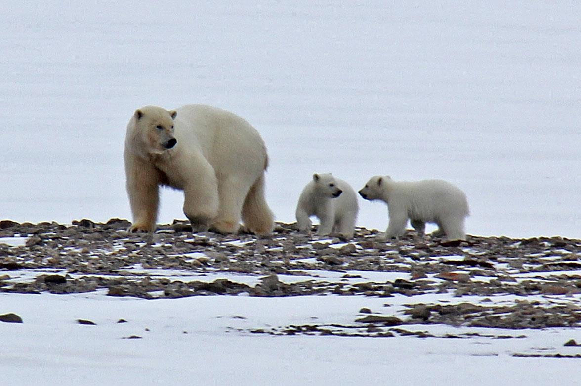
However, more interesting; a polar bear with her two cubs were somewhat further into the fjord
to our left, but heading out on a course that would certainly intersect our planned route.
Obviously, the bear should have the right of way. We skied slowly and she moved surprisingly fast
to the more outer areas of the Tempel fjord.
We skied across and then more parallel to the shore as we arrived at Fredheim around 1500.
Our ski trip had come to a fine conclusion,
another 17 kilometer of easy skiing was behind us.
We had 3 hours to wait and spent the time preparing the sleds for transport as well as looking
around. There is a second house that serves as a small shelter. We had no problem with the
time, this was, most likely, the last time to view this landscape. We also kept an eye out the
fjord to see if we could still spot the bear. Somewhat to our surprise, it seemed like she was
heading towards us. Yes indeed, she was getting closer to Fredheim just as the time moved
closer to our pick-up time. Our scooters were pretty much on time, but this also applied to the bear. She moved
onto the shore with her cubs close by and we moved a bit away from the houses. A warning shot was
fired with a rifle, she moved about 10 meter out, then resumed her approach. Soon, she was
sniffing around the buildings were we had spent the last 3 hours! We were as close as 60-70
meter, not much when we talk about polar bears. A golden opportunity to see the bear and her cubs
really close - a fantastic finale to our ski trip and a reward for all the long nights with
polar bear watch without (fortunately!!) ever seeing a bear.
The scooter transport back to Longyearbyen went reasonably fine. One of the sleds fell off the
scooter sled and a lot of content was scattered on the snow. Only 3 scooters came for the pickup, but one
pulled a sort of sled with a small tent - called the princess wagon. Arnt got the choice to ride
it, obviously very bumpy, but he survived it ok.
We stayed in Nybyen at the Spitsbergen Travel guesthouse this (unplanned) night.
Day 13, May 4th. We celebrate in Longyearbyen..
Today, we moved to the hotel named Basecamp where we had made a reservation for the last night
on Svalbard. The original plan had called for a scooter pickup on Saturday, so last night was
indeed unplanned. I filed the required report with the Sysselmannen office and we delivered back
all the rented gear (rifle, emergency beacon, satelite phone etc.) to Paulsen.
I made a dinner reservation for 1900 at the local Kroa restaurant and we all had a great
3 course dinner with a nice bottle of red wine. This was our last evening and we needed to
get up fairly early for our direct flight to Oslo leaving already at 0800.
Day 14, May 5th. We Fly home to Bergen.
The check-in went smoothly, no overweight charges this time either. We said goodbye to
Åke already at the hotel since he had not bought a return ticket and planned to spend a few
extra days in Longyearbyen. Arnt flew to Ålesund from Oslo, while Helge and I arrived in
Bergen on time at 1500. Heidi was there to pick us up and then drive Helge home before we
drove to Nattlandsfjellet in order to drop most of the luggage where it belonged. A nice dinner
followed, it felt good to be home.
This concluded our two week trip to Svalbard. It is remarkable how two weeks at Svalbard can be
filled with so many impressions, time just seems to slow down. Looking back, these two weeks
were so filled with (valuable) content that they seemed to last at least 5 times longer than
two weeks at the office. The single most important lesson was that a 4 man team is a bit marginal
wrt. continuous polar bear watch. A team of six would have improved this aspect considerably.
With this in mind, plus the bad weather and deep snow, a 20 kilometer skiing distance each day
is close to maximum. Before this trip started, I had assumed that we could average a distance closer
to 25 kilometer per day.
Warm thanks are due to Arnt, Helge and Åke for all efforts and contributions
to make this trip a very successful and memorable event.
Budget, what does a trip like this cost?
To organize a trip like this is not really difficult and it saves you a considerable
sum of money compared to the alternative of going with a commercial company.
The cost below is for 4 persons, most (but not all) scales with the number of participants.
I provide a rough, but fairly
accurate (2013) cost (main elements) in this table:
| Cost category | Cost in Euro |
|
| Air travel (Bergen - Longyearbyen, return) (May easily cost more!) | 1600.- |
| Accommodation in Longyearbyen, 3 nights (Lower in other seasons) | 1100.- |
| Food in Longyearbyen, 2 days | 500.- |
| Search and rescue Insurance, this is 10 percent of value set by Sysselmannen. | 1300.- |
| Scooter transport to Billefjorden | 2000.- |
| Scooter transport from Fredheim to Longyearbyen | 1000.- |
| Rentals (rifle, emergency beacon, sat-phone, signal pistol). | 1100.- |
| Food (48 Drytec - Real dinner). | 525.- |
| Topo-maps. | 150.- |
| Grand Total: | 8175.- |
| |
A commercial trip of roughly the same length is likely to cost at least twice as much.
The guided trips most often quote a cost excluding travel to/from Longyearbyen as well as
the (high) cost of staying there.
The above costs represent about 2000 Euro per person, or approximately 15.000 NOK.
Further information, Contacts and Links:
Here follows a few internet links
that may be useful for anybody that wants to plan and organize a trip to Svalbard.
The Governor of Svalbard - official pages.Permits, regulations etc.
Spitsbergen Travel.Equipment rentals, transportation etc.
The Norwegian Polar Institute,Information, air photos and maps of Svalbard.
Return to Petter's mountain page