Location: North 61:56.938 East 005:05.503 (GPS on the summit)
Difficulty: YDS class 1
Climbed February 4, 2012.
Information:
How to get there:
This is the "city mountain" of the village Måløy.
From the middle of Måløy (a main street when coming from the bridge), find
a road that heads uphill and generally will take you towards the left side of the housing
area. This road takes you higher and eventually turns right (near forest) There is a building at
the very top of the road, I parked there at location N61:56.155 E005:06.171, elevation about 138 meter.
Route description:
The route starts directly behind the building, across a small bridge. Follow the wide path (lights at night)
as it curves left then starts its way around the lake. Pay attention, just as this path curves left, the trail
to Veten forks off to the right. There are some small signs. This path is quite small and therefore may be missed.
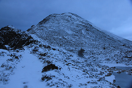
Follow this path across the first local knoll, then into the forest, climbing very gently. Later, the trail turns more left and uphill
in order to climb quite steeply along the ridge. When the trail tops out on the ridge, it crosses a few small humps then
zig-zags to the summit of Veten. There is a first, false summit. The next summit is a short ridge with the cairn at
the far end.
Comments:
I had skied to Kvasshornet earlier in the day and the time
was 1550 as I parked at the trailhead. I got under way by 1555 and walked on foot to the summit, arriving
in a strong storm at 1650. The wind speed down at the Måløy bridge read 21 m/s as I drove across.
(A big digital display warning the drivers.)
The wind up here was much stronger. In particular, at the very top. The wind pushed me towards the cairn and
actually pinned me there for a few minutes. Finally, as the force relented a bit, I ran back across the short
top ridge and got down onto the slope. The time was 1655 and I was back at the car by 1750. The last half of
the descent took place after dark, but I had brought along my strong flash light.