How to get there:
This mountain is in Austevoll. From Bergen, take the ferry
from Krokeide, then drive south from Hufthammar. One may start
from the signed trailhead for Loddo, and visit both peaks.
A shorter hike would be to start from the parking south-east of
lake Vinnesvatnet.
The Loddo trailhead has a signed exit (left) from the main road at a point where
the main road is running quite near the coast. The trailhead location is
N60.04668, E005.25938, elevation about 12 meter.
Route description:
Follow the nice walking path towards Loddo. This path has a signed fork that
heads right at a location (near big trees) where the Loddo trail bends left
and heads more uphill. About 100 meter before this location (when heading towards Loddo)
a somewhat vague trail forks right across a flat meadow. This trail had a sign that
had fallen to the ground, saying Veten (summer 2022). Take this trail, it is red marked
and becomes more visible/distinct after leaving the initial meadow.
This trail is signed for Veten, however when it is pretty near Skaftafjellet, there is
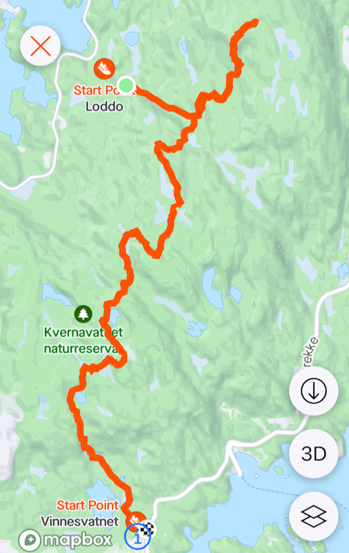
a fork and a separate trail forks left and ascends Skaftafjellet. See the route on
the map at the end of this text.
Skaftafjellet has a forest on top, the hill curves quite gently neaar the summit.
A summit cairn has been built between the trees.
Comments:
I did this climb directly after a visit to the island HP, Loddo.
After descending back to the trail signs, I continued 50-100 meter towards the trailhead
and located the fallen sign pointing towards Veten. This trail turned out to be
quite nice and easy to follow, only a bit vague in the very beginning. Well marked with
red paint.
I knew this trail went to Veten, I did not know if there was any trail to
Skaftafjellet. It still paid off to follow this Veten trail as long as reasonable,
since off-trail hiking looked quite cumbersome in many places.
When seeing Skaftafjellet up on my left, I finally decided to leave the trail and
head uphill. However, soon I found a new trail going my way. Thus, most likely
there is a trail fork that I would have found if I had stayed on the Veten trail just
a little bit longer.
I arrived at the Skaftafjellet summit at 1320, it had taken me about 1:20 since leaving
the summit of Loddo. I had agreed to meet my wife Heidi at some recreationl orienteering
location about half way between this summit and the
parking near lake Vinnesvatnet. She had dropped me at the Loddo trailhead and driven to
this parking in order to do some orienteering, finding about a dozen control locations.
Just below the summit, my track descended some steepish terrain, a better route is likely
to keep more right. Next, I crossed a meadow and hiked around a small lake before descending
on a trail to the agreed meeting location. Heidi had arrived there less than 5 minutes
ahead of me. We then continued down to the walking road that runs around the lake in order
to find our car.
