Location: North 62:32.852, East 007:01.423 (GPS at the summit)
Difficulty: YDS class 2
Climbed on April 5, 2008.
Information:
How to get there:
From Ålesund, drive E-39/E-136 towards Åndalsnes. You pass the place Sjøholt then the road
climbs gently up on Ørskogfjellet. On top, you first pass the general skiing area with parking on your
right, then note a small sign pointing right saying "Skitrekk" (Downhill slope). Turn right here. This road is
often closed, but there is often parking here right off the general highway. The distance from Ålesund is
slightly more than 40 kilometer. This is the trailhead, park here, location N62:32.450, E006:57.559, elevation
294 meter.
Route description:
Ski up the downhill slope towards the top of the highest (leftmost) ski lift. Before getting all the
way there, ascend towards your right and contour the steeper terrain that lies above the ski lift.
From there, continue uphill to the summit of Sandtinden, 1065 meter, location N62:32.663, E006:59.995.
From Sandtinden, continue along the connecting (broad) ridge across towards Sprovstinden. Stay away from
the steep side on your left (cornices in winter). The remaining slope is quite gentle to the flat summit
of Sprovstinden. Also, see the
more comprehensive information by Arnt Flatmo.
Comments:
I had arrived in Ålesund the evening before, picked up by my friend Arnt and
treated to a warm welcome. The weatherforecast for Saturday was not great, while the weather
was supposed to improve on Sunday. Since Arnt had climbed Sprovstinden just last week and also
skied it the normal way, we decided that I should make a (solo) attempt on Saturday.
I started from the road around 0940 (the access road to the ski area was closed and snowed in).
The weather was cloudy, variable wind and about 10 cm of new snow. As I started skiing up the downhill
slope, I noticed that the skins started to accumulate snow, always somewhat unpleasant.
At the top of the ski slope, I continued somewhat right and into the clouds. Higher up, I had a short
stretch with slightly steeper terrain and also somewhat icy. To make things even more unpleasant, the wind
picked up and had some gale strength gusts. I stopped and considered the situation. My conclusion was
that a short break in order to see if the weather would deteriorate or stabilize seemed wise. The wind
did indeed subside and I continued uphill, getting to the top of the subsidiary peak, Sandtinden 1065 meter,
at 1130. This peak has prominence 55 meter, being connected to Sprovstinden by a broad saddle.
The visibility was close to zero, but I did see the left cornice as I skied across the saddle. As always
in dense fog, this cornice looked really bad and I kept a respectful distance. The remaining stretch to
the summit of Sprovstinden was easy as I skied straight uphill using my GPS. I arrived on top at
12 noon, another dangerous cornice was barely visible otherwise a lot of snow. My GPS showed 1299, corresponding
to about 4 meter of snow, I guess the summit may still hold about 2 meter.
The return ski was quite uneventful, I called Arnt from the summit of Sandtinden, then had my lunch. Skiing
down, I reached the car at 1340, 4 hours after starting out.
Resources:
Images
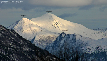
Sprovstinden, the route comes up the
valley behind Varguraksla (from the left), ascends Sandtinden, then connects to Sprovstinden.