How to get there:
The best starting point is the (old) powerplant at Hornaberg.
From Bergen, follow E-16 to Dale, then take the old road to Voss
that climbs steeply up Bergsdalen (exit right through the town of Dale).
Drive to the north-east end of the large lake Hamlagrøvatnet, then
turn right (small paved road) shortly after leaving the lake. Note that if
the lake is low (it is part of a hydro power storage basin), then this lake
is divided into two lakes. Follow the small road to the east side and park at a
large parking area next to the very easy to see, grey power plant building.
This is location N60.55819, E006.21080, elevation about 600 meter.
Note, that an alternative route is to continue on E-16 all the way to Bulken,
exit left there following the signed road to Hamlagrø. This road is about
the same distance, but of better quality to Bulken. The disadvantage is that
you pay toll before reaching Bulken.
Route description:
Follow the road that serves local cabins along the lake. Shortly, just after
crossing a small bridge, the road forks. Take the left (uphill) fork.
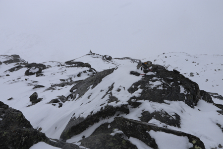
Follow this road until it ends. Continue along a trail running in the same direction
until you reach about 850 meter of elevation. You should now be at the main (south-west)
ridge of Skorane. Follow this ridge (turn left) to the summit.
Note that the highest point seems to be a bit beyond the cairn.
Comments:
The forecast was rain for Sat/Sun, but with Thursday as a holiday I
decided to make a 2-day mountain trip with the better forecast. I drove
to the trailhead and noted that there was snow in the air and white mountains
at a slightly higher elevation.
I started around 1200 noon, followed the road uphill until it ended, then
continued across in order to follow the ridge. Once at the ridge, I left my
backpack in the snow and hiked to the summit with my camera.
My GPS complained about weak batteries and I changed with a set of rechargeable that
I just had charged at home. Somewhat surprised when this set gave up as I recorded
the summit location, for some reason, the highest point was not where the
cairn had been built. Well, I carried yet another set of double-A batteries that now
took over.
Descending to my backpack, then directly further down to the valley. What! My GPS died again,
lack of battery power. Well, with no more spares, I said to myself that map and compass
worked in the past, so no big issue except that I like to record the summit locations
myself.
The big surprise was how much new snow had accumulated. On average about 30 cm, but with the
wind there were already drifts as deep as one meter. This hike was going to be hard work.
The weather did not improve as forecasted, the trail was invisible and the T-marking on rocks
and small cairns were largely buried. I decided to make it directly to Kiellandbu, my planned
overnight stay. This was hard work, I got a bit off-route on the lower part
of Sveindalsnuten, finding myself on top of some minor cliffs. However, soon I arrived to the
hut, still in deep snow. After starting the oven, I decided to do an early evening climb
of Sveindalsnuten, story continues there.