Location: North N59:31.124, East 008:46.757 (GPS at the summit)
Telemark, Norway
Difficulty: YDS class 2
Climbed: March 2, 2010
Information:
How to get there:
This mountain is located near the village of Seljord in Telemark.
Seljord is along the main east-west highway, E-134, about 60 kilometer from
the city Notodden. The mountain access road is called Grunningdalsvegen and has
a sign saying Grimås 8 km. The turnoff is right when coming from Seljord in the
direction of Oslo. As soon as you have left Seljord, you should look for this road and
sign. Coming in the opposite direction, you drive along Flatdal, then a lake on your
right hand side. After this lake, the road descends slightly and has several curves, look carefully
after this section. If you arrive in Seljord, you have gone too far.
Measure from the point where you leave E-134. After about 200 meter, stop and pay
toll (NOK 40 in 2010). At kilometer 6.7, you should start looking for a turnoff on your
right hand side, Turn right and contine steeply uphill. This road ends in a large
parking lot at kilometer 8. Park here, the loation is N59:30.756, E008:42.602, elevation
approximately 775 meter.
Route description:
This parking serves a number of vacation huts that are scattered across the hillside.
It is therefore normally a good track leading uphill. Follow this (it starts on the
right hand side of the parking area as seen when arriving by car), as it climbs uphill
while making some zig-zag curves. Higher up, the trail runs horizontally to your left
(when viewed uphill) before entering a small valley that heads straight up, a long and
pretty steep climb. This continues until location N59:30.511, E008:43.647, at which point
you have reached an elevation of 1030 meter. Here, the trail levels out and continues more
east as it has a few hills up as well as down, gradually turning slightly northeast in order
to reach the hut named Tjorbu. This trail is marked in the winter (small sticks). From
Tjorbu, leave the trail and traverse slightly uphill as you gradually turn left and enter the
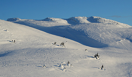
shallow valley that leads up to the lake at elevation 1111 meter, just below the mountain.
At the north side of this lake, you can find a nice slope that can be skied in order to
reach the west ridge, follow this to the main summit ridge. The terrain is nice and gentle
on the north side of this ridge. The summit cairn and register is located at the far end, ie.
at the east end of the mountain.
Comments:
I woke up around 6AM. Unlike a hotel or tourist hut where one can get breakfast, I
decided to do the ski trip first, then worry about breakfast as I started driving north.
Thus, a record early start at 0700. There were two cars at the large parking lot, no visible
sign of life. The moon was almost full, it hang low on the horizon, essentially over Seljord.
I skied up the rather long and steep hill, there were many old tracks around. I guess the families
that use the huts here have a standard challenge each day, to get the kids up this hill.
I was up above treeline in 30 minutes and continued more or less along the standard track towards
Tjorbu. The track was visible, but some new snow and some wind drift had erased any trace of
individual skiers. Beautiful morning, a slight wind and early rays of sunshine striking local
summits. I skied a bit left of Tjorbu and gained too much elevation too early, no big problem
as I descended back down to lake 1111. There were no signs of ski tracks up here, but I spotted
an old track higher on the ridge. The view was nice, but just as yesterday, the wind near the
top was strong enough to not stay very long. I had never skied on Lifjell before, the terrain
looked quite nice, generally rolling hills less steep than this summit area.
The climb had taken me 1:50, I spent 15 minutes on the top, then returned following the same route.
I intended to drive north to Gjendesheim in Jotunheimen, this is a long drive so being back
by the car at 1015 was quite ok. I stopped at the first gas station along the way and bought
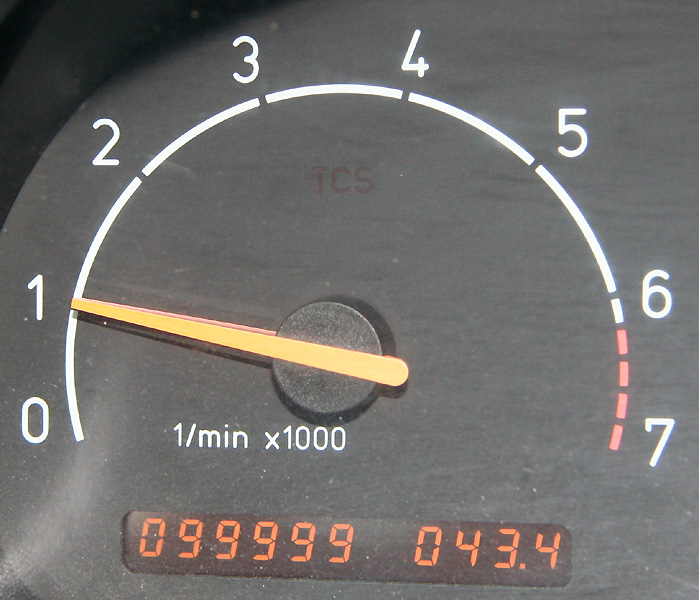
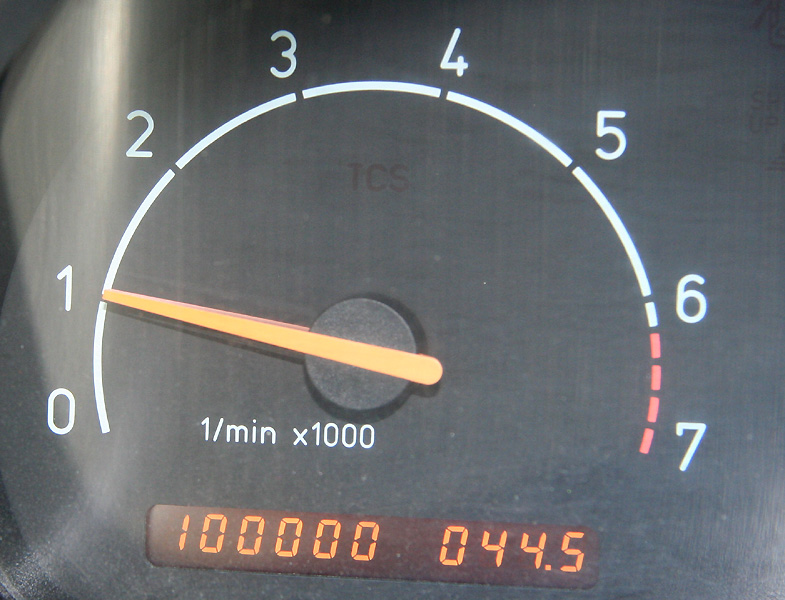
some breakfast. Shortly after the village of Notodden, my SAAB had its big day, finally after
13 years, the odometer changed
its leading zero with
a one, marking 100.000 miles of driving.
After dinner and a good night sleep at Gjendesheim, my next goal would be
Dyrtjørnhøi.