Location: N61.24.083, E005.37.638 (GPS on the summit)
Location: Near Bygstad, SW of the town Førde,
Sogn og Fjordane, Norway.
Climbed October 25 2003.
Information:
How to get there:
The best place to start is the small farm community Bygstad.
From the south, drive 15 km north from Vadheim (about 3 hours from
Bergen) along E-39 towards Førde.
Make a left on Hwy. 610 in Sande and continue 10 km to an intersection
called Osen. Make a sharp right here across a bridge and continue on a smaller
road.
The road narrows and takes you along the inner part of
Dalsfjorden shortly before Bygstad where the road forks.
From the north, you must drive
about 13 km south along E-39 from Førde then 12 km to the right along
Hwy. 57 in order to reach this intersection.
Continue west along the fjord, the sign says Laukeland.
Soon, the road heads
inland towards the
very impressive face of Kvamshesten, continue until
a sharp left bend on the road just as it crosses the creek.
Do not cross the creek, but take the road that goes right.
This is the second (main) road forking right after leaving the fjord.
Drive this road uphill and make a sharp right where this road crosses creek
number two. This is private land (the Rytnane farm) and you should ask permission to park and
follow the advice given, we parked at GPS location N61:23.401, E005:37.306, elevation 200 meter.
An alternative, and possibly better trailhead is described under the mountain
Blægja. Route description:
Start hiking along the private road that continues uphill towards the NE. As soon as this
road (not indicated on the map) levels off near the 400 meter elevation, head straight
left towards the mountain. There is a section of dense forest, hike west if necessary until
you locate an old trail that will lead you through the trees as it angles upward to the
small farm cabin Rabbane (see picture below).
From here, the trail continues uphill and to the right, whenever possible, take the highest
possible trail and head for the very characteristic cliff that marks the east end of
the continuous cliffs above you (see picture below). There is a small creek (from Skardavatnet, 715m)
that comes down here, there is a steep, but good trail going up on the east (right) side of
this creek.
From Skardavatnet, there is a (fairly steep) route directly to the summit along the east ridge of Kvamshesten.
However, due to the late October conditions with thin ice covering many rocks, we hiked a somewhat longer, but
easier route that comes up along the west ridge. In order to follow this route, hike north of the mountain
to Grunnevatnet (785m), continue west on the north side of this lake following the ridge, gradually turning
south and aim for point 1114m, a shoulder on the Kvamshesten west ridge. From here, continue up a distinct
gully, the route is marked with cairns. Higher up, the cairned route seemed to contour a bit on
the south side of the ridge, however, due to rather icy conditions, we found it easier and safer to head
directly up along good ledges and regain the top of the west ridge. The last section to the summit point is
then straightforward. Comments:
I did this hike with Arnt Flatmo. We started at 0945, made the summit
in a little less than 4 hours. After about 15 minutes on the summit
enjoying the fantastic 360 degrees views, we descended a somewhat shorter
route in about 2 hours. Including the roundtrip travel from Bergen, the
trip took 13 hours, a very nice late October hike.
Resources:
Images
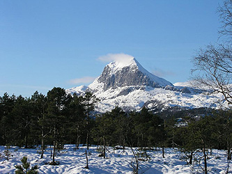
Kvamshesten as seen from Hwy. 39 south of Førde, February 15. 2004.
Kvamshesten towering above the first section of the route.
Panorama view, from NE to SW, from left to right, Litlehesten, 912m, the
East ridge of Kvamshesten, the farms at Bygstad. The "lakes" directly below is
actually the inner part of Dalsfjorden.